Old Town Hall, Walthamstow

Last updated

Old Town Hall, Walthamstow
Walthamstow Old Town Hall - geograph.org.uk - 1463183.jpg
Old Town Hall, Walthamstow
LocationOrford Road, Walthamstow
Coordinates 51°34′59″N0°00′42″W / 51.5830°N 0.0117°W / 51.5830; -0.0117
Built1866
Architectural style(s) Italianate style
Listed Building – Grade II
Official nameOld Town Hall
Designated15 November 1988
Reference no. 1191150
Greater London UK location map 2.svg
Red pog.svg
Shown in London

The Old Town Hall is a former municipal building in Orford Road, Walthamstow, London. The building served in a municipal capacity from 1866 to 1942 and then served as the main entrance block to the Connaught Hospital from 1959 to 1977. It is a Grade II listed building. [1]

Contents

History

Use as the old town hall

The first building on the site was a single storey public hall, which was used for entertainment and probably dated back to the first half of the 19th century. [2] In the mid-19th century, the Walthamstow Local Board decided to demolish the earlier building and commission a new building on the site with the intention that it take over the role of local seat of government from the Vestry House in Vestry Road. [3]

The new building was designed in the Italianate style, built in yellow brick with stucco dressings and was completed in 1866. The design involved a symmetrical main frontage of five bays facing onto Orford Road. The central section of three bays, which was slightly projected forward, featured a portico formed by Doric order columns on pedestals supporting an entablature and a parapet, with a canted window on the first floor. The flanking bays were fenestrated by round headed windows with architraves and keystones on both floors, while the outer bays were fenestrated by tri-partite round headed windows on the ground floor and by tri-partite square headed windows on the first floor. [1]

After the area became an urban district in 1895, the building served as council offices, and after the area became a municipal borough in 1929, [4] [5] it served as the town hall. It remained the main civic building in Walthamstow until 1942 when the council moved to a new building. The civic furnishings were removed from the old town hall at that time. [6] It then remained empty until being converted for hospital use in 1959. [2]

Use as a hospital

The facility has its origins in a small hospital for sick children established by a Mr and Mrs Tudor in a private house in Brandon Road in 1878. [7] [8] The hospital moved to Salisbury Road as the Leyton, Walthamstow and Wanstead Hospital in 1880. [7] After acquiring additional premises, known as "Holmcroft" in Orford Road, the facility became the Children's and General Hospital for Leyton, Leytonstone, Walthamstow and Wanstead in 1894. [7] It was renamed the Connaught Hospital after its patron, the Duchess of Connaught, in 1928. [7] It acquired additional facilities in Orford Road in 1930 and, after joining the National Health Service in 1948, expanded further acquiring the old town hall in Orford Road as well in 1959. [7]

Later uses

After patients had been transferred to the North Middlesex Hospital, the hospital closed in 1977 [9] and, while most of the hospital buildings behind the old town hall were subsequently demolished, the old town hall itself was converted into an I-Kuan Tao temple [10] and the former pathology department became the Waltham Forest Asian Centre, later the Waltham Forest Community Hub. [11]

Related Research Articles

<span class="mw-page-title-main">Leyton</span> Town in east London, England

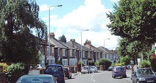
Leyton is a town in east London, England, within the London Borough of Waltham Forest. It borders Walthamstow to the north, Leytonstone to the east, and Stratford to the south, with Clapton, Hackney Wick and Homerton, across the River Lea, to the west. The area includes New Spitalfields Market, Leyton Orient Football Club, as well as part of the Queen Elizabeth Olympic Park. The town consists largely of terraced houses built between 1870 and 1910, interspersed with some modern housing estates. It is 6.2 miles (10 km) north-east of Charing Cross.

<span class="mw-page-title-main">Walthamstow</span> Town in London, England

Walthamstow is a town in the London Borough of Waltham Forest, around 7.5 miles (12 km) east of Central London. The town borders Chingford to the north, Snaresbrook and South Woodford to the east, Leyton and Leytonstone to the south, and Tottenham to the west. At the 2011 census, the town had a population of approximately 109,424.

<span class="mw-page-title-main">London Borough of Waltham Forest</span> London borough in United Kingdom

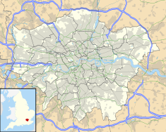
The London Borough of Waltham Forest is an outer London borough formed in 1965 from the merger of the municipal boroughs of Leyton, Walthamstow and Chingford.

<span class="mw-page-title-main">Leytonstone</span> Area of East London

Leytonstone is an area in east London, England, within the London Borough of Waltham Forest. It adjoins Wanstead to the north-east, Forest Gate to the south-east, Stratford to the south-west, Leyton to the west, and Walthamstow to the north-west, and is 7 miles (11 km) north-east of Charing Cross.

<span class="mw-page-title-main">Walthamstow Village</span> Human settlement in England

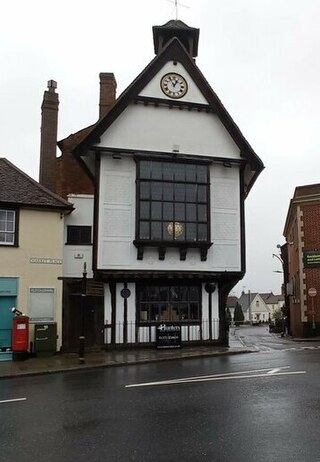
Walthamstow Village is the oldest part of Walthamstow, east London. It was designated a Conservation Area by the London Borough of Waltham Forest in 1967, and another Conservation Area on nearby Orford Road was subsequently added. The area centres on St. Mary's Church, which was founded in the 12th century. Across the road from this is a 15th-century timber-framed hall house called "The Ancient House", which was restored in 1934 and 2002. Nearby are almshouses dating from the 16th and 18th centuries, and the Vestry House Museum, which has been used as a workhouse and police station, but has been a museum since 1931. It also holds the archives of the borough and a local studies library.

<span class="mw-page-title-main">Municipal Borough of Leyton</span>

Leyton was a local government district in southwest Essex, England, from 1873 to 1965. It included the neighbourhoods of Leyton, Leytonstone and Cann Hall. It was suburban to London, forming part of the London postal district and Metropolitan Police District. It now forms the southernmost part of the London Borough of Waltham Forest in Greater London.

<span class="mw-page-title-main">Municipal Borough of Walthamstow</span>

Walthamstow was a local government district in southwest Essex, England from 1873 to 1965, around the town of Walthamstow. It was within the London suburbs, forming part of the London postal district and Metropolitan Police District. Its former area now corresponds to the central part of the London Borough of Waltham Forest in Greater London. Its population and area grew rapidly as London continued to develop its suburbs.

<span class="mw-page-title-main">Cann Hall</span> Human settlement in England

Cann Hall is a former civil parish in the south of Leytonstone in the London Borough of Waltham Forest. It is north of Stratford and Forest Gate, east of Leyton, and west of Wanstead Flats, the southernmost tip of Epping Forest.

<span class="mw-page-title-main">Vestry House Museum</span> Museum in Walthamstow, London

Vestry House Museum is a history museum in Walthamstow focusing on the heritage of the local area. The collection includes various artefacts dating from the Victorian era to the 20th century, including numerous archived documents and photographs.

<span class="mw-page-title-main">Waltham Forest Town Hall</span> Municipal building in London, England

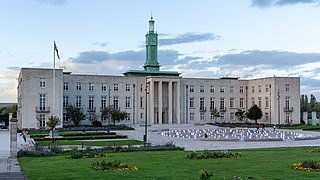
Waltham Forest Town Hall is a municipal building located in Walthamstow, East London. The town hall, which is the headquarters of Waltham Forest London Borough Council, is a Grade II Listed Building.

<span class="mw-page-title-main">Leyton Town Hall</span> Municipal building in London, England

Leyton Town Hall is a municipal building in Adelaide Road, Leyton, London. The building, which includes Leyton Great Hall, is a Grade II listed building.

<span class="mw-page-title-main">Denny Town House</span> Municipal building in Denny, Scotland

Denny Town House is a municipal building in Glasgow Road, Denny, Falkirk, Scotland. The structure is used by Falkirk Council for the provision of local services.

<span class="mw-page-title-main">Kirkwall Town Hall</span> Municipal building in Kirkwall, Scotland

Kirkwall Town Hall is a municipal building in Broad Street, Kirkwall, Orkney, Scotland. The structure, which is currently used as a community events venue, is a Category B listed building.

<span class="mw-page-title-main">Highland Council Headquarters</span> Council headquarters in Inverness, Scotland

The Highland Council Headquarters, formerly County Buildings, is a municipal structure in Glenurquhart Road, Inverness, Highland, Scotland. The oldest part of the complex, which currently serves as the headquarters of The Highland Council, is a Category C listed building.

<span class="mw-page-title-main">Forfar Sheriff Court</span> Judicial building in Forfar, Scotland

Forfar Sheriff Court is a judicial building in Market Street, Forfar, Angus, Scotland. The building, which remains in use as a courthouse, is a Category B listed building.

<span class="mw-page-title-main">Old Town Hall, Great Dunmow</span> Municipal building in Great Dunmow, Essex, England

The Old Town Hall is a municipal building in the Market Place, Great Dunmow, Essex, England. The structure, which is now in retail use, is a Grade II listed building.

<span class="mw-page-title-main">Sandwich Guildhall</span> Municipal building in Sandwich, Kent, England

Sandwich Guildhall is a municipal building in the Cattle Market, Sandwich, Kent, England. The structure, which accommodates the offices and meeting place of Sandwich Town Council, is a Grade II* listed building.

<span class="mw-page-title-main">Pembroke Town Hall, Dublin</span> Municipal building in Ballsbridge, County Dublin, Ireland

Pembroke Town Hall is a municipal building in Merrion Road, Ballsbridge, Dublin, Ireland. The building currently accommodates the offices of the City of Dublin Vocational Education Committee.

<span class="mw-page-title-main">Old Town Hall, Wombwell</span> Municipal building in Wombwell, South Yorkshire, England

The Old Town Hall is a former municipal building in the High Street, Wombwell, South Yorkshire, England. The structure, which is currently used as a public house, is a locally listed building.

<span class="mw-page-title-main">Dalton Town Hall</span> Municipal building in Dalton-in-Furness, Cumbria, England

Dalton Town Hall is a municipal building in Station Road, Dalton-in-Furness, a town in Cumbria, England. The building, which accommodates the offices and meeting place of Dalton-in-Furness Town Council, is a Grade II listed building.

References

  1. 1 2 Historic England. "Old Town Hall, Walthamstow (1191150)". National Heritage List for England . Retrieved 11 May 2020.
  2. 1 2 "What is on the site of this grand public hall today?". Epping Forest Guardian. 19 January 2020. Retrieved 26 January 2023.
  3. "Orford Road Conservation Area" (PDF). Waltham Forest Council. p. 6. Retrieved 26 January 2023.
  4. Powell, W R (1973). "'Walthamstow: Local government and public services', in A History of the County of Essex". London: British History Online. pp. 275–285. Retrieved 15 September 2020.
  5. Collier, Lindsay (2014). Walthamstow Through Time. Amberley Publishing. ISBN   978-1445621944.
  6. "Fellowship Square Trail" (PDF). Waltham Forest Council. p. 4. Retrieved 26 January 2023.
  7. 1 2 3 4 5 "Connaught Hospital". Lost Hospitals of London. Retrieved 11 May 2020.
  8. "The Connaught Hospital in Orford Road" (PDF). Walthamstow Memories. Retrieved 26 January 2023.
  9. "Snapshot from the past: Orford Road retail parade". Walthamstow Village Residents' Association. Retrieved 26 January 2023.
  10. "An I-Kuan Tao temple has opened in the former Walthamstow town hall building, in Orford Road". East London and West Essex Guardian. 10 August 2009. Retrieved 11 May 2020.
  11. "Venue Hire". Waltham Forest Hub. Retrieved 6 April 2024.