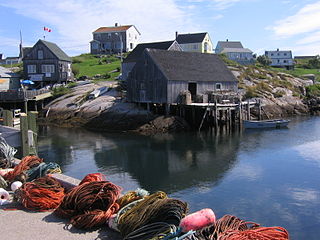
Peggy's Cove is a small rural community located on the eastern shore of St. Margarets Bay in the Halifax Regional Municipality, which is the site of Peggys Cove Lighthouse.
Enfield is an urban community located 5 kilometres (3.1 mi) north of Halifax Stanfield International Airport in the Shubenacadie Valley on the border of Hants and Halifax counties in Nova Scotia, Canada. Specifically, Enfield exists in both the East Hants Municipal District and Halifax and is divided by the Shubenacadie River.

The Quinpool District refers to a commercial district of Halifax, Nova Scotia, encompassing the eastern portion of Quinpool Road as well as the streets directly north and south of it. Prominent landmarks on Quinpool Road include the Atlantica Hotel, the Oxford Theatre, and an eclectic variety of local businesses, including many popular Chinese and Greek restaurants.

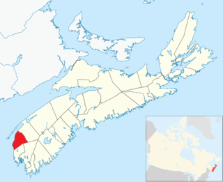
Clare, officially named the Municipality of the District of Clare, is a district municipality in western Nova Scotia, Canada. Statistics Canada classifies the district municipality as a municipal district.
East Preston is an expansive rural Black Nova Scotian community located in eastern Halifax Regional Municipality, Nova Scotia, in Atlantic Canada. The population at the time of the 2016 census was 869.

The Musquodoboit River is a Canadian river located in central Nova Scotia in the northeastern part of Halifax Regional Municipality. The river is approximately 97 kilometres (60 mi) in length with roughly 88 kilometres (55 mi) being traversable by paddle. It has a watershed area of 1,409 square kilometres (544 sq mi)
The Shubenacadie Valley is a Canadian rural region in central Nova Scotia.

McNabs Island is the largest island in Halifax Harbour located in Halifax Regional Municipality, Nova Scotia, Canada. It played a major role in defending Halifax Harbour and is now a provincial park. The island was settled by Britons in the 1750s and later by Peter McNab, and McNab family members lived on the island until 1934.
Dollar Lake Provincial Park is a seasonal provincial park located in the Musquodoboit Valley area of the Halifax Regional Municipality in Nova Scotia, Canada, in the community of Wyses Corner, 22 kilometres from the Halifax International Airport on the Old Guysborough Road.
West Lawrencetown is a residential community within the Halifax Regional Municipality Nova Scotia on the Eastern Shore on Route 207 along the scenic route Marine Drive.

East Lawrencetown is a rural community within Halifax Regional Municipality in Nova Scotia, Canada on the Eastern Shore on Route 207 along the scenic route Marine Drive. The community is 22.4 kilometers from Halifax. Lawrencetown Beach Provincial Park is located in the community, at the southern end of Lawrencetown Lake, a natural ocean inlet. The beach is a year-round destination for surfing, attracting both locals and those from abroad. There are also places to park vehicles, stroll along boardwalks, hike, mountain bike and swim. Available to the public in the summer is a canteen, showers, flush toilets and a section of beach that is supervised by the Nova Scotia Lifeguard Service.

Beaver Bank is a suburban community northeast of Lower Sackville on the Beaver Bank Road in Nova Scotia, Canada, within the Halifax Regional Municipality. It is about 35 kilometres from the City of Halifax.
Beechville is a Black Nova Scotian settlement and suburban community within the Halifax Regional Municipality of Nova Scotia, Canada, on St. Margaret's Bay Road. The Beechville Lakeside Timberlea (BLT) trail starts here near Lovett Lake, following the old Halifax and Southwestern Railway line. Ridgecliff Middle School, located in Beechville Estates, serves the communities of Beechville, Lakeside, and Timberlea.
Nova Scotia Museum (NSM) is the corporate name for the 28 museums across Nova Scotia, Canada, and is part of the province's tourism infrastructure. The organization manages more than 200 historic buildings, living history sites, vessels, and specialized museums and about one million artifacts and specimens, either directly or through a system of co-operative agreements with societies and local boards. The NSM delivers programs, exhibits and products which provide both local residents and tourists in Nova Scotian communities an opportunity to experience and learn about Nova Scotia's social and natural history. More than 600,000 people visit the facilities each year.

Lake Egmont is a small rural community in the lower interior of the Musquodoboit Valley, in the Halifax Regional Municipality of Nova Scotia, Canada. Other communities in this area include Antrim and Wyses Corner, Nova Scotia. The community was named after John Perceval, 2nd Earl of Egmont.
Micou's Island is a 22-acre (89,000 m2) tidal island located in the Glen Haven community near the eastern shore of St. Margarets Bay, Nova Scotia, Canada. The island is accessible by a sandbar at low tide and has become a popular beach during summer months.
French Village is a rural community of the Halifax Regional Municipality in the Canadian province of Nova Scotia on Chebucto Peninsula. French village initially included present day villages of Tantallon, Glen Haven and French Village. The French that migrated to the area were French speaking families from the Principality of Montbeliard and known as the "Foreign Protestants". They had come to Nova Scotia between 1750 and 1752 to settle Lunenburg, Nova Scotia. Contrary to belief, they were not Huguenots. The church is the community is St. Paul's Church. In 1901, the Halifax and Southwestern Railway was built through the area and the railway choose the name French Village for the station serving the three communities. The French Village station, actually located in Tantallon, has been preserved as a cafe beside the recreational trail that follows the old Halifax & Southwestern Railway roadbed.

Seaforth is a community of the Halifax Regional Municipality in the Canadian province of Nova Scotia. Seaforth is home to the Hope For Wildlife Society, an organisation dedicated to helping injured wild animals. The community was named for Seaforth, Merseyside, in England.
Pleasant Point is a community of the Halifax Regional Municipality in the Canadian province of Nova Scotia.
There are various Black Lakes in Nova Scotia, Canada. They vary widely in size, depth and usability. Many counties, such as Cumberland, Halifax, Inverness, and Pictou Counties have more than one Black Lake so named, while other counties mentioned in this article have only one named Black Lake.


