Olef Dam

Last updated

Oleftalsperre (15).JPG

View from the south. Left rear: the dam
Location Euskirchen
Coordinates 50°29′42″N6°25′17″E / 50.4950°N 6.4215°E / 50.4950; 6.4215 Coordinates: 50°29′42″N6°25′17″E / 50.4950°N 6.4215°E / 50.4950; 6.4215
Construction began 1954–1959
Dam and spillways
Impounds Olef
Height (foundation) 59 m
Height (thalweg) 54.6 m
Length 282 m
Elevation at crest 466.9 m
Width (crest) 5.7 m
Dam volume 123,000 m3
Reservoir
Total capacity 20,3 Mm3
Active capacity 19.3 Mm3
Catchment area 47.92 km2
Surface area 1.1 km2
Normal elevation 465.5 m

The Olef Dam (German : Oleftalsperre) is located in the vicinity of the Eifel National Park near Hellenthal within the High Fens-Eifel Nature Park in the county of Euskirchen in the German state of North Rhine-Westphalia. Its reservoir stores around 20 million cubic metres and is fed by the River Olef.

German language West Germanic language

German is a West Germanic language that is mainly spoken in Central Europe. It is the most widely spoken and official or co-official language in Germany, Austria, Switzerland, South Tyrol (Italy), the German-speaking Community of Belgium, and Liechtenstein. It is also one of the three official languages of Luxembourg and a co-official language in the Opole Voivodeship in Poland. The languages which are most similar to German are the other members of the West Germanic language branch: Afrikaans, Dutch, English, the Frisian languages, Low German/Low Saxon, Luxembourgish, and Yiddish. There are also strong similarities in vocabulary with Danish, Norwegian and Swedish, although those belong to the North Germanic group. German is the second most widely spoken Germanic language, after English.

Eifel National Park national park in North Rhine-Westphalia, Germany

The Eifel National Park is the 14th national park in Germany and the first in North Rhine-Westphalia.

Hellenthal Place in North Rhine-Westphalia, Germany

Hellenthal is a municipality in the district of Euskirchen in the state of North Rhine-Westphalia, Germany. It is located in the Eifel hills, near the border with Belgium, approx. 30 km south-west of Euskirchen and 40 km south-east of Aachen.

Contents

Description

The Olef Dam was built between 1954 and 1959 for two purposes: to protect the surrounding municipalities from floods; and to supply drinking water. In 1965 the valley was completely filled with water for the first time and the dam officially opened. There were two subsequent construction phases to reinforce it: 1962–1965 and 1982–1986. The dam is made of concrete and is of the buttress type and is unique in Germany. [1]

Dam A barrier that stops or restricts the flow of surface or underground streams

A dam is a barrier that stops or restricts the flow of water or underground streams. Reservoirs created by dams not only suppress floods but also provide water for activities such as irrigation, human consumption, industrial use, aquaculture, and navigability. Hydropower is often used in conjunction with dams to generate electricity. A dam can also be used to collect water or for storage of water which can be evenly distributed between locations. Dams generally serve the primary purpose of retaining water, while other structures such as floodgates or levees are used to manage or prevent water flow into specific land regions. The earliest known dam is the Jawa Dam in Jordan, dating to 3,000 BC.

Buttress dam dam with a solid, water-tight upstream side that is supported at intervals on the downstream side by a series of buttresses or supports

A buttress dam or hollow dam is a dam with a solid, water-tight upstream side that is supported at intervals on the downstream side by a series of buttresses or supports. The dam wall may be straight or curved. Most buttress dams are made of reinforced concrete and are heavy, pushing the dam into the ground. Water pushes against the dam, but the buttresses are inflexible and prevent the dam from falling over.The Buttress dam does however, run into certain problems that are not as prevalent in other dams. Even though they tend to be more economical they run the risk of not reaching the proper height required to become effective. An example would be as follows with a slope of 50 degrees the crown of each arch will have to be 0.84 feet farther forward at the crest than at the base for each foot of height. This defect will demand that the dam is either much taller than calculated or a lot wider to accommodate for it problem. Another issue is that the dam has to have a proper foundation of bedrock or other suitable material. If the buttresses for the dam are not properly seated the dam runs the chances of a possible collapse. Some problems that might occur during the construction of a buttress dam is cracks along the convex side near the cresting of the dam due to thermal stresses and the dam not being ‘loaded’. Once the dam has been reinforced if cracks continue to occur the cracks will close once the force of the water is against it.

Other uses of the dam are to raise low water levels, industrial water processing and hydropower generation. The power station capacity is 3 MW, its annual energy production is 2.6 GWh. The storage power station is operated by RWE Innogy.

The dam belongs to the Wasserverband Eifel-Rur. Because of its proximity to the Belgian border, its western half is within the safety template of the Elsenborn Training Area in the Belgian municipality of Bütgenbach.

Bütgenbach Municipality in German-speaking Community, Belgium

Bütgenbach is a municipality located in the Belgian province of Liège. On January 1, 2006, Bütgenbach had a total population of 5,574. The total area is 97.31 km² which gives a population density of 57 inhabitants per km². As part of the German-speaking Community of Belgium, the official language in this municipality is German.

The dam had to be reinforced twice because large variations in temperature and shrinkage of the concrete produced greater internal stresses than were foreseen, leading to cracks. The initially open downstream side was sealed in order to limit the temperature variations.

The shortest circular route around the reservoir is 13 km long. It runs along the lakeshore and is open to cyclists. Its northern side is largely tarmacked.

In early April 2007 the downstream face of the dam was decorated by artist, Klaus Dauven, with high pressure cleaners as part of Project Wildwechsel. It portrays forest and river animals from the area. [2]

See also

Related Research Articles

Ahr river in Germany

Ahr is a river in Germany, a left tributary of the Rhine. Its source is at an elevation of approximately 470 metres (1,540 ft) above sea level in Blankenheim in the Eifel, in the cellar of a timber-frame house near the castle of Blankenheim. After 18 kilometres (11 mi) it crosses from North Rhine-Westphalia into Rhineland-Palatinate.

Rur river in Germany and the Netherlands

The Rur or Roer is a major river that flows through portions of Belgium, Germany and the Netherlands. It is a right (eastern) tributary to the Meuse. About 90 percent of the river's course is in Germany.

Möhne Reservoir reservoir

The Möhne Reservoir, or Moehne Reservoir, is an artificial lake in North Rhine-Westphalia, some 45 km east of Dortmund, Germany. The lake is formed by the damming of two rivers, Möhne and Heve, and with its four basins stores as much as 135 million cubic metres of water.

Eschbach Dam dam in Germany

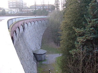
The Eschbach Dam was the first dam to be built in Germany for drinking water supply. It is located in Remscheid, North Rhine-Westphalia, Germany. With its opening in 1891, this pioneer work of hydraulic engineering was a milestone in the economic development of the city of Remscheid.

Sorpe Dam reservoir near the town of Sundern in Germany

The Sorpe Dam is a dam on the Sorpe river, near the small town of Sundern in the district of Hochsauerland in North Rhine-Westphalia, Germany.

The Rur Eifel lies in the district of Düren in the German state of North Rhine-Westphalia, and is a local recreation area from the regions of Cologne, Aachen, Düsseldorf, Krefeld, Mönchengladbach and Bonn. Its name comes from the river Rur and the Eifel Mountains.

The Zitter Forest is located in the Eifel region in the German district of Euskirchen and in the Belgian province of Liège (Wallonia). Its highest point is 692 m above sea level (NN).

Daniel-Johnson Dam

The Daniel-Johnson Dam, formerly known as Manic-5, is a multiple-arch buttress dam on the Manicouagan River that creates the annular Manicouagan Reservoir. The dam is composed of 14 buttresses and 13 arches and is 214 km (133 mi) north of Baie-Comeau in Quebec, Canada. The dam was constructed between 1959 and 1970 for the purpose of hydroelectric power production and supplies water to the Manic-5 and Manic-5-PA power houses with a combined capacity of 2,596 MW. The dam is 214 m (702 ft) tall, 1,314 m (4,311 ft) long and contains 2,200,000 m3 of concrete, making it the largest dam of its type in the world.

Olef river

The Olef is a river in Liège, Belgium and North Rhine-Westphalia, Germany. It is 27.9 kilometres long and a left-hand tributary of the Urft. It flows through the Eifel Mountains in the western part of the Germany and eastern part of Belgium.

Urft (river) river of North Rhine-Westphalia, Germany

The Urft is a 46.4-kilometre-long (28.8 mi) right-hand tributary of the Rur in the county of Euskirchen in the German state of North Rhine-Westphalia. It flows through the village of Urft in the municipality of Kall. The Urft rises in the North Eifel region of the Eifel Mountains.

Urft Dam dam in Germany

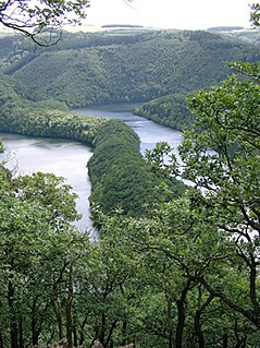
The Urft Dam is a 58.50 metre high dam in the southwestern part of the state of North Rhine-Westphalia in Germany. It was built in 1905. The dam impounds the River Urft in the district of Euskirchen to create the Urft Reservoir (Urftstausee), 2.16 km² in area. The reservoir is also called the Urftsee.

Haba River Shankou Dam

The Haba River Shankou Dam is a concrete-face rock-fill dam on the Haba River, a tributary of the Irtysh River. It is located in Habahe County of the Xinjiang Uyghur Autonomous Region in China. The primary purpose of the dam is hydroelectric power generation, flood control and water supply for civil and irrigation use. It supports a 25.2 MW power station.

Little Rock Dam

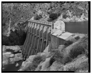
Little Rock Dam, also known as Littlerock Dam, or officially as Little Rock-Palmdale Dam, is a concrete gravity dam on Little Rock Creek in Los Angeles County, California, about 5 mi (8.0 km) south of Palmdale. The dam and Little Rock Reservoir are owned by the Palmdale Water District and Littlerock Creek Irrigation District and are used for agricultural and municipal water supply and flood control.

Perlenbach Valley valley

The Perlenbach Valley is the valley of the Perlenbach stream in the Eifel mountains in the countries of Belgium and Germany. The Perlenbach itself is a tributary of the Rur. The Perlenbach Valley is host to two outstanding, cultural-historical nature reserves along the state border which have a total area of 398 ha.

Schöneseiffen Stadt of Schleiden in North Rhine-Westphalia, Germany

Schöneseiffen is a village southwest of Schleiden in the county of Euskirchen| in the German state of North Rhine-Westphalia. The Dieffenbach stream rises north of the village. Schöneseiffen has a population of about 415. Schöneseiffen has sports field, a Bürgerhaus and a youth centre.

Platißbach river in Germany

The Platißbach is a roughly seven-kilometre-long (4.3 mi), southern and orographically right-hand tributary of the River Olef in the municipality of Hellenthal in Germany.

References

  1. There is only one other buttress dam in Germany, the Linach Dam, but it is a subgroup of the Gewölbereihenstaumauer type.
  2. "Oleftalsperre - Hellenthal, Deutschland | Kärcher". kaercher.de. Retrieved 2017-11-29.

Literature