Related Research Articles

Bronkhorstspruit is a town 50 km east of Pretoria, Gauteng, South Africa along the N4 highway towards eMalahleni. It also includes three townships called Zithobeni, Rethabiseng and Ekangala. On 18 May 2011, the Tshwane Metropolitan Municipality took over the municipal administration from the abolished Kungwini Local Municipality, which makes Bronkhorstspruit part of Tshwane.

Cederberg Municipality is a local municipality which governs an area of the Western Cape province of South Africa stretching from the Cederberg mountains through the middle valley of the Olifants River to the Atlantic coast. It includes the towns of Clanwilliam, Citrusdal and Lamberts Bay, and the surrounding villages and farms. As of 2011 it had a population of 49,768. It is located within the West Coast District Municipality and its municipality code is WC012.

Hoedspruit is a town situated at the foot of the Klein Drakensberg, in the Limpopo province of South Africa, on the railway line from Tzaneen to Kaapmuiden.

The Olifants River,Lepelle, iBhalule or Obalule is a river in South Africa and Mozambique, a tributary of the Limpopo River. It falls into the Drainage Area B of the Drainage basins of South Africa. The historical area of the Pedi people, Sekhukhuneland, is located between the Olifants River and one of its largest tributaries, the Steelpoort River.
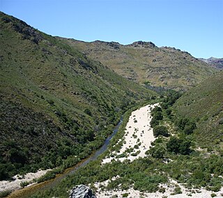
The Olifants River is a river in the northwestern area of the Western Cape Province of South Africa. The upper and main catchment area of the Olifants river is around Ceres and the Cederberg mountains. The Clanwilliam and Bulshoek dams are located on the river and provide water for the towns and farms along the watercourse. The river is approximately 285 km long with a catchment area of 46,220 km2. It flows into the Atlantic Ocean at Papendorp, 250 km north of Cape Town.

The R36 is a provincial route in South Africa that connects the N1 at Bandelierkop with Ermelo, via Tzaneen and Lydenburg. It is co-signed with the N4 for 8 kilometres between Machadodorp and Patattanek, with a tollgate on this section. It used to extend further south past Ermelo to Amersfoort, but that section is now designated as part of the N11.
Blyde River Canyon Nature Reserve is situated in the Drakensberg escarpment region of eastern Mpumalanga, South Africa. The reserve protects the Blyde River Canyon, including sections of the Ohrigstad and Blyde Rivers and the geological formations around Bourke's Luck Potholes, where the Treur River tumbles into the Blyde below. Southwards of the canyon, the reserve follows the escarpment, to include the Devil's and God's Window, the latter a popular viewpoint to the lowveld at the reserve's southern extremity.

Balule Nature Reserve is a protected area in Limpopo Province, South Africa which forms part of the Greater Kruger National Park as a member of the Associated Private Nature Reserves (APNR). As part of a wildlife conservation initiative, all fences separating APNR reserves – Balule, Timbavati, Klaserie, Umbabat, – and the Kruger National Park have been removed.

Associated Private Nature Reserves, (APNR), is an association of privately owned nature reserves bordering on the Kruger National Park. Collectively they represent 1,800 square kilometres (180,000 ha) of land dedicated to conservation. In June 1993 the fences between Kruger National Park and the APNR were removed.

Blyderivierpoort Dam is a gravity-arch dam on the Blyde River, in the lower Blyde River Canyon, near Hoedspruit in Mpumalanga, South Africa. It also floods the lower reaches of the Blyde's Ohrigstad River tributary. The dam was completed in 1974. The 71 m high dam wall and 22 m deep is situated 3 km from Swadini resort by road.

Rhenosterkop Dam is combined gravity and arch type dam in Mpumalanga Province, South Africa. It is located on the Elands River, part of the Olifants River basin. The dam was established in 1984.

The Motlatse River, Blyde River, or Umdhlazi River is a river in the Mpumalanga and Limpopo provinces of South Africa. It has a northwards course in steep-sided valleys and ravines of the Mpumalanga Drakensberg, before it enters the lowveld region of the Limpopo province. It has its ultimate origins at around 2,000 m altitude in the Hartebeesvlakte conservation area, to the north of Long Tom Pass. It runs through the Blyde River Canyon.
Ohrigstad River is located in Mpumalanga, South Africa. The Ohrigstad River joins the Blyde River at the Blyderivierpoort Dam in the Blyde River Canyon Nature Reserve. Like the Blyde, it has its ultimate origin at around 2,000 m altitude to the south, on the verge of the Hartebeesvlakte conservation area, but follows a more westerly course.

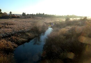
The Bronkhorst Spruit, meaning watercress stream or creek, is a river in the Mpumalanga and Gauteng provinces of South Africa. In the 19th century it as was known as the Kalkoenkransrivier or Rhenosterpoortrivier. It is a tributary of the Wilge River in the Olifants River basin, and it lends its name to the town of Bronkhorstspruit, situated mainly on its right bank.
The Wilge River (iKuthu) is a river in Mpumalanga and Gauteng provinces, South Africa. It is a tributary of the Olifants River.
Elands River may refer to any of the following rivers in South Africa:

The Elands River is a river in the former Transvaal area, South Africa. It is a tributary of the Olifants River, part of the Limpopo River basin.
The Vaalkop Dam is a combined gravity and earth-fill type dam located in North West Province, South Africa. Its reservoir is located at the confluence of the Elands River and the Hex River, part of the Crocodile basin. The dam was established originally in 1972 and was renovated in 2008 in order to supply water for the platinum and associated metals mining operations in the area. The dam mainly serves for irrigation purposes, municipal water supply and industrial uses. The hazard potential of the dam has been ranked high.
The R555 is a Regional Route in South Africa that connects Springs with Ohrigstad via Delmas, Ogies, Witbank, Middelburg, Stoffberg and Burgersfort.
The Klaserie River is a river in Limpopo Province, South Africa. It flows northeastwards and is a tributary of the Olifants River, joining it at 90° in the west of the Kruger National Park.