Olinda | |
|---|---|
Neighborhood of Brea | |
 | |
| Coordinates: 33°55′27″N117°50′52″W / 33.92414785100306°N 117.8476746137632°W | |
| Country | United States |
| State | California |
| County | Orange County |
| City | Brea, California |
| Reference no. | 918 [1] |
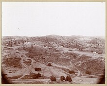
Olinda is a neighborhood in Brea, California, located on Carbon Canyon Road east of the rest of the city. [2] The original village was founded in the 1890s and grew when petroleum was discovered at the adjacent Brea-Olinda Oil Field. In February 1917, Olinda Village and the nearby town of Randolph were incorporated as the city of Brea. The site is now registered as California Historical Landmark #918 registered on January 1. 1978. [1]
Contents
Olinda Landfill, located in Carbon Canyon, was opened in 1960 and is scheduled to be closed in December 2021.
The name was revived for a quiet neighborhood built in the hills near the site of the original village, beginning in 1964. The neighborhood has six streets, and holds about 120 homes (many horse properties), and a condominium complex. It is near Carbon Canyon Regional Park and Chino Hills State Park, and surrounded by hills covered with chaparral and home to coyotes, owls, hawks and rattlesnakes.
A Southern California Edison electrical substation in the area is also named Olinda. Olinda gives its name to an elementary school as well as Brea-Olinda High School, which serves Brea and Olinda.