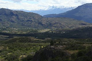
Alto Palena Airport is an airport serving Palena, a small town in the mountains of the Los Lagos Region of Chile. Palena is 5 kilometres (3.1 mi) from the Argentina border. The airport is just north of the town, and south of a bend in the Palena River.
Vodudahue Airport Spanish: Aeropuerto Vodudahue, is an airstrip 56 kilometres (35 mi) northeast of Chaitén, a town in the Los Lagos Region of Chile. The airstrip is in the valley of the Vodudahue River, 5 kilometres (3.1 mi) east of where the river empties into the Comau Fjord. The valley extends eastward into Pumalín Park.

Cochrane Airport Spanish: Aeródromo Cochrane, is an airport serving Cochrane, a town in the Aysén Region of Chile. The airport is just northwest of the town, at the foot of Cerro Tamanguito (sv).
La Pelicana Airport is an airstrip serving Combarbalá, a small town in the Coquimbo Region of Chile. The airstrip is 13 kilometres (8.1 mi) north of Combarbalá, in a river valley near the hamlet of Cogoti.
Futaleufú Airfield Spanish: Aeródromo Futaleufú, is an airport serving Futaleufú, a town in the Los Lagos Region of Chile.
La Junta Airport Spanish: Aeropuerto La Junta, is an airport serving La Junta (es), a small town in the Aysén Region of Chile. La Junta is on the Carretera Austral highway, 50 kilometres (31 mi) inland from the Gulf of Corcovado.
Arquilhue Airport Spanish: Aeropuerto Arquilhue, is an airstrip at Arquilhue, a village in the Los Lagos Region of Chile. Arquilhue is 20 kilometres (12 mi) east of Llifén.
Villa Portales Airport, is an airport 1 kilometre (0.62 mi) east-northeast of Lonquimay, a town in the Araucanía Region of Chile.
San Rafael Airport Spanish: Aeródromo de San Rafael de Los Andes, is an airport serving Los Andes, a city in the Valparaíso Region of Chile. The airport is 5 kilometres (3.1 mi) west-northwest of the city.
Carolina Airport, is an airport located 2 kilometres (1.2 mi) north of Michilla (es), a town in the Antofagasta Region of Chile. The airport is on the Pacific coast and serves the ore processing facility of the Michilla copper mine.
Alupenhue Airport, is an airport 23 kilometres (14 mi) southeast of Molina, a city in the Maule Region of Chile.
Ñadis Airport is an airstrip serving settlements in the valleys of the Barrancoso and Baker Rivers in the Aysén Region of Chile.
Juan Kemp Airport, is an airstrip on the southern shore of Rupanco Lake in the Los Lagos Region of Chile. The nearest town is Entre Lagos, 30 kilometres (19 mi) northwest on neighboring Puyehue Lake.
Peulla Airport is an airport serving Peulla (es), a village near the shore of Todos los Santos Lake in the Los Lagos Region of Chile. The village is at the head of the fjord-like lake, where the Peulla River empties into it.
El Principal Airport, is an airstrip in the Pirque commune of the Santiago Metropolitan Region in Chile.
Cabo Juan Román Airport, is an airport serving Puerto Aysén, a city at the head of the Aysén Fjord in the Aysén Region of Chile.
Puerto Ingeniero Ibáñez Airport, is an airport serving Puerto Ingeniero Ibáñez, a town in the Aysén Region of Chile. The town is at the head of Ibáñez Bay, a bay off the northern side of General Carrera Lake. The runway lies between the mouth of the Ibáñez River and the town.
Las Brujas Airport is an airport serving Salamanca, a town in the Coquimbo Region of Chile.
Municipal de Vitacura Airport is a general aviation airport in Vitacura, a northern suburb of the Santiago Metropolitan Region of Chile. The airport is in a narrow slot between a major city street in Vitacura and a parallel freeway.
Vicuña Airport Spanish: Aeropuerto de Vicuña or El Indio Airport, is an extremely high elevation airstrip 66 kilometres (41 mi) east-northeast of Vicuña, Coquimbo, Chile.


