Omanesep

Last updated
Omanesep
Indonesia South Papua location map.svg
Red pog.svg
Omanesep
Location of Omanesep in South Papua
Coordinates: 5°55′47″S138°20′28″E / 5.92972°S 138.34111°E / -5.92972; 138.34111
CountryFlag of Indonesia.svg  Indonesia
Province South Papua
Regency Asmat
District Betcbamu
Climate Af

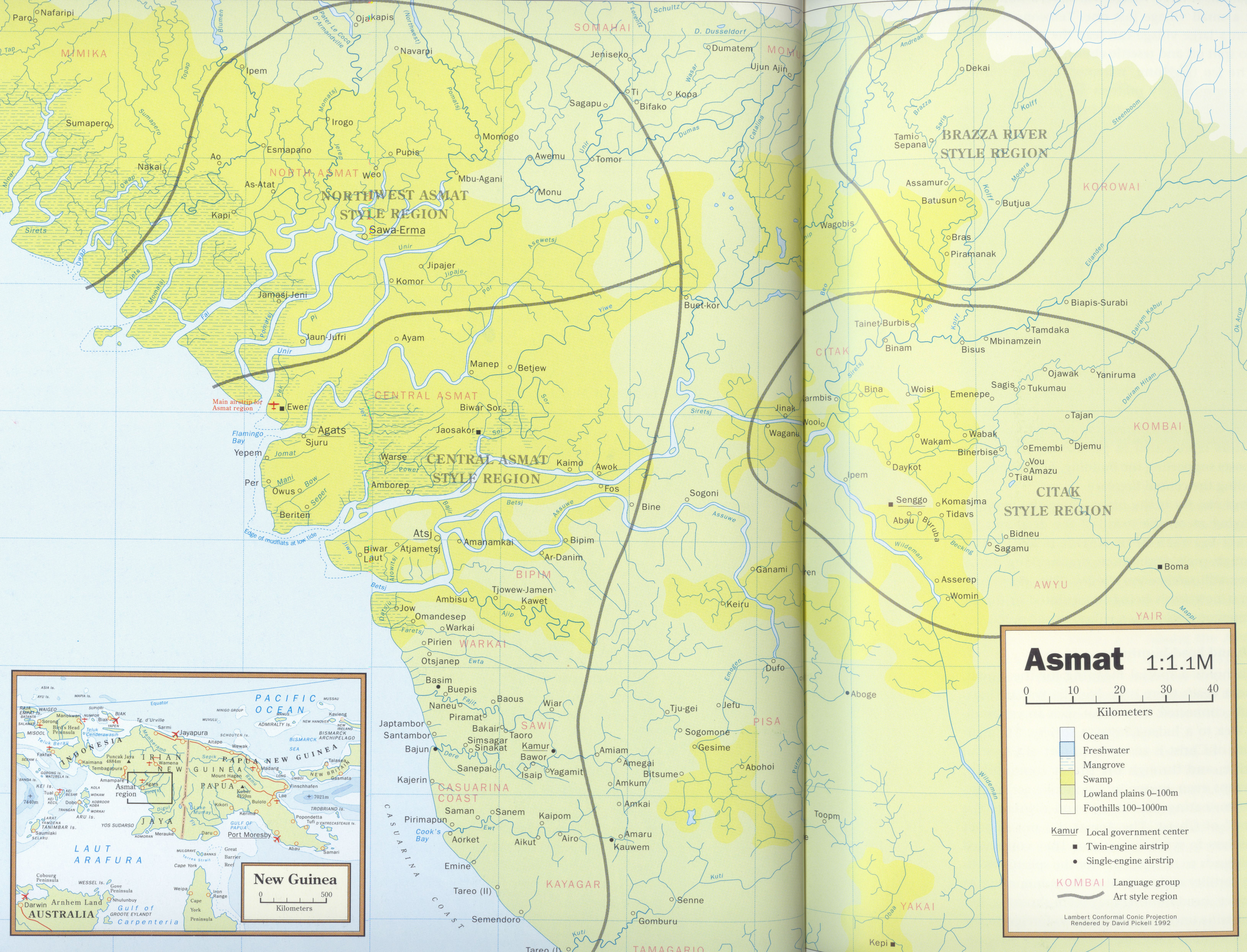
Omanesep (also spelled Omandesep) is a village in Asmat Regency, South Papua, Indonesia. Omandesep is situated to the south of the villages of Agats and Atsy. [1] [2]

Related Research Articles

<span class="mw-page-title-main">Bali</span> Province and island in Indonesia

Bali is a province of Indonesia and the westernmost of the Lesser Sunda Islands. East of Java and west of Lombok, the province includes the island of Bali and a few smaller offshore islands, notably Nusa Penida, Nusa Lembongan, and Nusa Ceningan to the southeast. The provincial capital, Denpasar, is the most populous city in the Lesser Sunda Islands and the second-largest, after Makassar, in Eastern Indonesia. The upland town of Ubud in Greater Denpasar is considered Bali's cultural centre. The province is Indonesia's main tourist destination, with a significant rise in tourism since the 1980s. Tourism-related business makes up 80% of its economy.

<span class="mw-page-title-main">Indonesia</span> Country in Southeast Asia and Oceania

Indonesia, officially the Republic of Indonesia, is a country in Southeast Asia and Oceania between the Indian and Pacific oceans. It consists of over 17,000 islands, including Sumatra, Java, Sulawesi, and parts of Borneo and New Guinea. Indonesia is the world's largest archipelagic state and the 14th-largest country by area, at 1,904,569 square kilometres. With over 279 million people, Indonesia is the world's fourth-most-populous country and the most populous Muslim-majority country. Java, the world's most populous island, is home to more than half of the country's population.

<span class="mw-page-title-main">Java</span> Island in Indonesia

Java is one of the Greater Sunda Islands in Indonesia. It is bordered by the Indian Ocean to the south and the Java Sea to the north. With a population of 151.6 million people, Java is the world's most populous island, home to approximately 56% of the Indonesian population. Indonesia's capital city, Jakarta, is on Java's northwestern coast.

<span class="mw-page-title-main">North Sumatra</span> Province of Indonesia

North Sumatra is a province of Indonesia located in the northern part of the island of Sumatra. Its capital and largest city is Medan. It is bordered by Aceh on the northwest and Riau and West Sumatra on the southeast, with two different coastlines located on the Indian Ocean and the Strait of Malacca, and a maritime border with Malaysia to the east. North Sumatra is Indonesia's fourth most populous province after West Java, East Java, and Central Java, and is also the most populous province outside of Java Island. North Sumatra is also the third-largest province in area on the island of Sumatra after South Sumatra and Riau provinces. It covers an area of 72,460.74 km2, which is approximately the same size as Sierra Leone or Scotland or Maine.

<span class="mw-page-title-main">Jambi</span> Province of Indonesia

Jambi is a province of Indonesia. It is located on the east coast of central Sumatra and stretches to the Barisan Mountains in the west. Its capital and largest city is also called Jambi. It is bordered by the provinces of Riau to the north, West Sumatra to the west, Bengkulu to the southwest, South Sumatra to the south, and shares a maritime border with the Riau Islands to the east and the Pacific Ocean to the east. The province has a land area of 49,026.58 km2, and a sea area of 3,274.95 km2.It's area is comparable to the European country,Slovakia.It had a population of 3,092,265 according to the 2010 census and 3,548,228 according to the 2020 census; the official estimate of population as of mid-2022 was 3,631,136.

<span class="mw-page-title-main">Buru</span> Island in Maluku, Indonesia

Buru is the third largest island within the Maluku Islands of Indonesia. It lies between the Banda Sea to the south and Seram Sea to the north, west of Ambon and Seram islands. The island belongs to Maluku province and includes the Buru and South Buru regencies. Their administrative centers, Namlea and Namrole, respectively, have ports and are the largest towns of the island, served by Namlea Airport and Namrole Airport respectively.

<span class="mw-page-title-main">Torajan people</span> Ethnic group from South Sulawesi, Indonesia

The Torajans are an ethnic group indigenous to a mountainous region of South Sulawesi, Indonesia. Their population is approximately 1,100,000, of whom 450,000 live in the regency of Tana Toraja. Most of the population is Christian, and others are Muslim or have local animist beliefs known as aluk. The Indonesian government has recognised this animistic belief as Aluk To Dolo.

<span class="mw-page-title-main">Tangerang</span> Largest city of Banten, Indonesia

Tangerang is a city in the province of Banten, Indonesia. Located on the western border of Jakarta, it is the third largest urban centre in the Greater Jakarta metropolitan area after Jakarta and Bekasi; the sixth largest city proper in the nation; and the largest city in Banten province. It has an area of 164.55 km2 (63.53 sq mi) and an official 2010 Census population of 1,798,601, which had risen to 1,895,486 at the 2020 Census – making it the eighth most populated suburb in the world at the latter date; the official estimate as at mid 2023 was 1,912,679 - comprising 961,354 males and 951,325 females.

<span class="mw-page-title-main">South Jakarta</span> Administrative city in Jakarta, Indonesia

South Jakarta, abbreviated as Jaksel, is one of the five administrative cities which form the Special Capital Region of Jakarta, Indonesia. South Jakarta is not self-governed and does not have a city council, hence it is not classified as a proper municipality. It had a population of 2,062,232 at the 2010 census and 2,226,812 at the 2020 census, and 2,244,623 as at mid 2022 according to the official estimates. It is the third most populous among the five administrative cities of Jakarta, after East Jakarta and West Jakarta. The administrative centre is at Kebayoran Baru.

Indonesia is divided into provinces. Provinces are made up of regencies and cities (kota). Provinces, regencies, and cities have their own local governments and parliamentary bodies.

In Indonesia, village or subdistrict is the fourth-level subdivision and the smallest administrative division of Indonesia below a district, regency/city, and province. Similar administrative divisions outside of Indonesia include barangays in the Philippines, Muban in Thailand, civil townships and incorporated municipalities in the United States and Canada, communes in France and Vietnam, dehestan in Iran, hromada in Ukraine, Gemeinden in Germany, comuni in Italy, or municipios in Spain. The UK equivalent are civil parishes in England and communities in Wales. There are a number of names and types for villages in Indonesia, with desa being the most frequently used for regencies, and kelurahan for cities or for those communities within regencies which have town characteristics. According to the 2019 report by the Ministry of Home Affairs, there are 8,488 urban villages and 74,953 rural villages in Indonesia. North Aceh Regency contained the highest number of rural villages (852) amongst all of the regencies of Indonesia, followed by Pidie Regency with 730 rural villages and Bireuen Regency with 609 rural villages. Prabumulih, with only 12 rural villages, contained the fewest. Counted together, the sixteen regencies of Indonesia containing the most rural villages—namely, North Aceh (852), Pidie (730), Bireuen (609), Aceh Besar (604), Tolikara (541), East Aceh (513), Yahukimo (510), Purworejo (469), Lamongan (462), South Nias (459), Kebumen (449), Garut (421), Bojonegoro (419), Bogor (416), Cirebon (412), and Pati (401)—contain one-third of all the rural villages in Indonesia. Five of these are located in Aceh, two in Highland Papua, three in Central Java, two in East Java, three in West Java, and one in North Sumatra. An average number of rural villages in the regencies and 15 cities of Indonesia is 172 villages. A village is the lowest administrative division in Indonesia, and it is the lowest of the four levels. A village is usually divided into a number of hamlets, and there are 252,315 hamlets in Indonesia.

<span class="mw-page-title-main">Bird's Head Peninsula</span> Peninsula in Indonesia

The Bird's Head Peninsula or Doberai Peninsula, is a large peninsula that makes up the northwest portion of the island of New Guinea, comprising the Indonesian provinces of Southwest Papua and West Papua. It is often referred to as The Vogelkop, and is so named because its shape looks like a bird's head on the island of New Guinea. The peninsula at the opposite end of the island is called the Bird's Tail Peninsula. The peninsula just to the south is called the Bomberai Peninsula.

<span class="mw-page-title-main">South Tangerang</span> City in Banten, Indonesia

South Tangerang is a city in the province of Banten, Indonesia. Located 30 km (19 mi) on the southwestern border of Jakarta, the city forms part of the Greater Jakarta metropolitan area. It was administratively separated from Tangerang Regency on 26 November 2008. According to the 2020 Census, the city population was 1,354,350 inhabitants, while the official estimate as at mid 2023 was 1,404,785 - comprising 700,754 males and 704,031 females. The total area is 164.85 km2 (63.65 sq mi). It is the second-largest city in Banten in terms of population, and has grown rapidly, not only as Jakarta's satellite city, but also the development of business districts and commerce due to presence of large-scale planned town by private developers.

<span class="mw-page-title-main">Ma'anyan people</span> Ethnic group in Indonesia

Ma'anyan, Dayak Maanyan or Eastern Barito Dayak people are an ethnic group of the Dayak people indigenous to Borneo. They are also considered as part of the east Barito Dusun group with the name Dusun Ma'anyan. According to J. Mallinckrodt (1927), the Dusun people group is part of the Ot Danum people cluster, although later that theory was disproved by A. B. Hudson (1967), who argues that the Ma'anyan people are a branch of the Barito family. The Ma'anyan people who are often referred to as Dayak people are also referred to as Dayak Ma'anyan. The Dayak Ma'anyan people inhabit the east side of Central Kalimantan, especially in the East Barito Regency and parts of South Barito Regency which are grouped as Ma'anyan I. The Dayak Ma'anyan people also inhabit the northern parts of South Kalimantan, especially in Tabalong Regency which refers to the Dayak Warukin people. The Dayak Balangan people or Dusun Balangan people which are found in the Balangan Regency and the Dayak Samihim people that are found in the Kotabaru Regency are grouped together with the Dayak Ma'anyan people group. The Dayak Ma'anyan people in South Kalimantan are grouped as Ma'anyan II.

West Damar, or North Damar, is an Austronesian language of Damar Island, one of the Maluku Islands of Indonesia. In spite of rather low cognacy rates with its neighboring languages, it can be classified as part of the Babar languages based on qualitative evidence.

<span class="mw-page-title-main">Tamil Indonesians</span>

Tamil Indonesians are persons from Indian Tamil ancestry living in Indonesia. Majority of them live in Medan in North Sumatra while there are small community in other parts of the country such as Jakarta, Aceh, Riau and Riau Islands. It is estimated that there are around 25,000 PIOs/NRIs living in Indonesia of which the Indian expatriate community registered with the Embassy and Consulate in Medan numbers around 30,000.

Kimki (Aipki) or Sukubatom (Sukubatong) is a South Pauwasi language of Batom District, Pegunungan Bintang Regency, Papua, Indonesia. Foley classifies Kimki as a language isolate, although he notes some similarities with Murkim. Usher demonstrates a connection to the other South Pauwasi languages.

Emem, or Emumu, is an Eastern Pauwasi language in Keerom Regency, Papua Province. It has only 25% lexical similarity with Zorop, the most distinct Eastern Pauwasi language.

Dusun Deyah, or Deyah, is a language spoken by a group of Dusun people of South Kalimantan province, Indonesia. It is spoken in Tabalong Regency across two districts: Haruai, in the villages of Kinarum, Kaong, Pangelak, and Bilas, and Muara Uya, especially in the village of Mangkopom.

<span class="mw-page-title-main">Thousand Islands (Indonesia)</span> Administrative regency in Jakarta, Indonesia

The Thousand Islands are a chain of islands to the north of Jakarta's coast. It forms the only regency of Special Capital Region of Jakarta, the metropolitan province of Indonesia. It consists of a string of 342 islands stretching 45 km (28 mi) north into the Java Sea at West Jakarta Bay and in fact are located to the north of Banten Province. Pramuka Island is the regency seat. The islands, along with North Jakarta City, are the only administrative divisions of Jakarta Special Capital Region with a coastline.

References

  1. "Indonesia" by Ryan Ver Berkmoes, Celeste Brash, Muhammad Cohen, Mark Elliott, Guyan Mitra, John Noble, Adam Skolnick, Iain Stewart, and Steve Waters. Lonely Planet. 2010. p. 816.
  2. http://ufdcimages.uflib.ufl.edu/UF/E0/01/08/41/00001/smidtmap.jpg [ bare URL image file ]