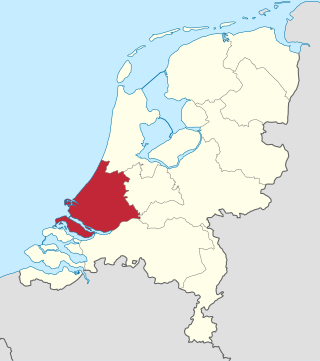
South Holland is a province of the Netherlands with a population of over 3.7 million as of October 2021 and a population density of about 1,373/km2 (3,560/sq mi), making it the country's most populous province and one of the world's most densely populated areas. Situated on the North Sea in the west of the Netherlands, South Holland covers an area of 3,307 km2 (1,277 sq mi), of which 607 km2 (234 sq mi) is water. It borders North Holland to the north, Utrecht and Gelderland to the east, and North Brabant and Zeeland to the south. The provincial capital is the Dutch seat of government The Hague, while its largest city is Rotterdam. The Rhine-Meuse-Scheldt delta drains through South Holland into the North Sea. Europe's busiest seaport, the Port of Rotterdam, is located in South Holland.

The Waal is the main distributary branch of the river Rhine flowing approximately 80 km (50 mi) through the Netherlands. It is the major waterway connecting the port of Rotterdam to Germany. Before it reaches Rotterdam, it joins with the Afgedamde Maas near Woudrichem to form the Boven Merwede. Along its length, Nijmegen, Tiel, Zaltbommel and Gorinchem are towns of importance with direct access to the river.
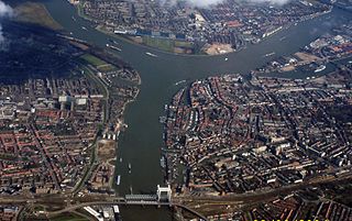
The Drechtsteden are a number of towns and cities bordering each other in the delta area of the rivers Oude Maas, Noord, and Beneden-Merwede in the province of South Holland, Netherlands. These cooperate in the Gemeenschappelijke Regeling Drechtsteden, which performs common tasks for the municipalities in the field of economy, development, culture, and social assistance. Collectively, a little more than 250,000 people call one of the towns and cities of Drechtsteden home.

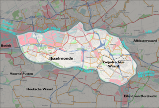
IJsselmonde is a river island in the Netherlands, between the Nieuwe Maas, Noord and Oude Maas branches rivers of the Rhine-Meuse delta in the province of South Holland. The city of Rotterdam now occupies most of the northern part of the island and includes the eponymous former village of IJsselmonde, once a separate community. The island was once a rich agricultural region but is mostly suburbs today. Only the mid-south parts of the island have retained their agricultural character.
Alblasserdam is a town and municipality in the western Netherlands, in the province of South Holland. It covers an area of 10.06 km2 (3.88 sq mi), of which 1.28 km2 (0.49 sq mi) is water, and has a population of 20,136 as of 2021. Alblasserdam is officially a part of the Drechtsteden region. A portion of the small village of Kinderdijk, which boasts the largest and most famous concentration of windmills in the Netherlands, is part of Alblasserdam.

Hendrik-Ido-Ambacht is a town and municipality in the western Netherlands. It is located on the island of IJsselmonde, and borders with Zwijndrecht, Ridderkerk, and the Noord River.
Ridderkerk is a town and municipality in the western Netherlands, in the province of South Holland. The municipality had a population of 46,671 in 2021 and covers an area of 25.26 km2 (9.75 sq mi) of which 1.54 km2 (0.59 sq mi) is covered by water.

Haaften is a village in the Dutch province of Gelderland, on the northern shore of the river Waal, about opposite Zaltbommel. It is a part of the municipality of West Betuwe, and lies about 25 km south of Utrecht.

Varik is a village in the Dutch province of Gelderland. It is a part of the municipality of West Betuwe, and lies about 8 km south of Tiel.
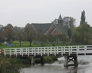
Rijsoord is a village in the Dutch province of South Holland. It is located about 10 km southeast of the city of Rotterdam, in the municipality of Ridderkerk.
Sandelingen Ambacht is a polder about 12 km southeast of Rotterdam and a neighborhood of Hendrik-Ido-Ambacht, South Holland.

ASWH, short for Altijd Sterker Worden Hendrik-Ido-Ambacht, is an association football club from Hendrik-Ido-Ambacht, Netherlands. The club was founded in 1929. It won section championships in 1949, 1959, 1961, 1970, 1883, 1999, 2001, 2002, and 2005. In 2005 ASWH also won the Dutch Championship of Amateur Soccer and the Dutch Championship of Saturday Soccer. Ascending gradually through the ranks, ASWH played 2019–2022 in the semi-professional Tweede Divisie. In 2023, it joined the Vierde Divisie, after relegating twice for the first time in the club's history. In 2023–2024, ASWH operates 70 teams in competitions.
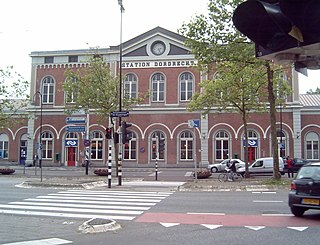
Dordrecht is a railway station in Dordrecht, Netherlands located on the Breda–Rotterdam railway and the Elst–Dordrecht railway. The station was opened on 1 January 1872, when the railway line between Rotterdam and Antwerp was opened. On 16 July 1885, the railway line from Dordrecht to Gorinchem was opened. The neo-Renaissance railway station building is located to the south of the city centre. Dordrecht is now an important railway station on the Nederlandse Spoorwegen railway network. The services to Gorinchem and Geldermalsen are operated by Arriva.
Zuid-Holland Zuid is an official region of the province of South Holland in the Netherlands.

Rotterdam Lombardijen is a railway station in the Dutch city of Rotterdam, located on the Breda–Rotterdam railway between Rotterdam and Dordrecht. The railway station is located in the borough of IJsselmonde. The station opened on 1 June 1964 with wooden platforms and no more than a trailer for ticket sales. On 12 September 1968 a station building was opened; the current station building dates from 1996. Train services are operated by Nederlandse Spoorwegen.
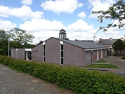
De Brave Hendrik was a fine dining restaurant in Hendrik-Ido-Ambacht, Netherlands. It was awarded one Michelin star in 1990 and retained that rating until 1996.
The Waaltje is a dammed river in the western Netherlands, southeast of Rotterdam. Historically it used to be the western end of the Waal river, hence its official name continues to be Waal, although the intermediate Waal sections, Boven Merwede, Beneden Merwede, and a subsection of the Noord, have long changed their names.

Ido's Football Club, usually known as IFC, is a Dutch association football club from Hendrik-Ido-Ambacht. Its grounds are at Sportpark Schildman.

Ramon Hendriks is a Dutch professional footballer who plays as a defender for Eredivisie club Vitesse, on loan from Feyenoord.