Opbrakel

Last updated
Opbrakel
Village
PM 135853 B Opbrakel.jpg
View on Opbrakel
Belgium location map.svg
Red pog.svg
Opbrakel
Location in Belgium
Coordinates: 50°47′33″N3°44′53″E / 50.7925°N 3.7481°E / 50.7925; 3.7481
Country Flag of Belgium (civil).svg  Belgium
Region Flemish Region
Province East Flanders
Municipality Brakel
Area
[1]
  Total8.74 km2 (3.37 sq mi)
Population
 (2021) [1]
  Total1,648
  Density190/km2 (490/sq mi)
Time zone CET

Opbrakel is a village and deelgemeente (sub-municipality) of the municipality of Brakel. It is located in the Denderstreek in the province of East Flanders in Belgium. It used to be an independent municipality until 1971 when it was merged into Brakel.

Contents

Overview

The area used to be covered in forest, but only the Brakelbos  [ nl ] to the south of Opbrakel has remained. [2] The forest has become a 52 hectares (130 acres) nature area and varies in height from 65 to 130 metres. [3]

The village was first mentioned in 866 as villa Braglo, and is a Germanic forest name. Opbrakel used to be a heerlijkheid , and used to have a castle named Herenhof which was demolished in 1863. In 1885, a railway station opened on the Zottegem to Ronse railway line. [2] The railway line closed in 1963. [4]

The grist mill Verrebeekmolen was built between 1789 and 1803. In 1909, an electro motor was installed in the windmill, and by 1938 the windmill was no longer in operation. It was repaired between 1996 and 1997. It is in service every last Sunday of the month and open for visitors. [5]

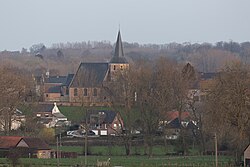
The St Martinus Church is a three aisled basilica-like church with an octagonal tower from the 13th century. The church dates from the mid 18th century. Unlike most churches it is oriented to the north. [3] [6]

In 1963, the municipality borders were corrected based on language, and the neighbourhood of d'Hutte which used to belong to Flobecq was transferred to Opbrakel. [2] The municipality covered an area of 8.42 square kilometres (3.25 sq mi). In 1971, Opbrakel was merged into the municipality of Brakel and became a deelgemeente . [7] The village is mainly an agricultural community, but is developing into a commuter's village. [2]

Notable people

Related Research Articles

<span class="mw-page-title-main">Bouwel</span> Village in Flemish Region

Bouwel is a deelgemeente in the Belgian province of Antwerp; it is attached to the municipality of Grobbendonk.

<span class="mw-page-title-main">Nederbrakel</span> Town in Flemish Region

Nederbrakel is a town in the municipality of Brakel. It is located in the Denderstreek and in the Flemish Ardennes, the hilly southern part of the province of East Flanders, Belgium. With 5,972 residents as of 2000, it forms the largest individual part of the municipality. Nederbrakel is located near the language border.

<span class="mw-page-title-main">Michelbeke</span> Village in Flemish Region

Michelbeke is a village in the municipality of Brakel, Belgium. It is located in the Denderstreek and in the Flemish Ardennes, the hilly southern part of the province of East Flanders, Belgium. It was itself a municipality until the fusion of the municipalities on 1 January 1971.

<span class="mw-page-title-main">Welden, Belgium</span> Village in Flemish Region

Welden is a village in the municipality of Oudenaarde in the province of East Flanders, Belgium, and is situated along the Scheldt. It is located about 20 kilometres (12 mi) south of Ghent.

<span class="mw-page-title-main">Parike</span> Village in Flemish Region

Parike is a village and deelgemeente (sub-municipality) of the municipality of Brakel. It is located in the Denderstreek in the province of East Flanders in Belgium. It used to be an independent municipality until 1977 when it was merged into Brakel.

<span class="mw-page-title-main">Eine, Belgium</span> Place in Flemish Region, Belgium

Eine is a village located in the province of East Flanders, Belgium. Since 1965, it has been a deelgemeente (subdivision) of the municipality of Oudenaarde.

<span class="mw-page-title-main">Erwetegem</span> Village in Flemish Region

Erwetegem is a village and deelgemeente (sub-municipality) belonging to the municipality of Zottegem. It is located in the Denderstreek and in the Flemish Ardennes, the hilly southern part of the province of East Flanders, Belgium. Erwetegem used to be an independent municipality until 1970.

<span class="mw-page-title-main">Vinderhoute</span> Village in Flemish Region

Vinderhoute is a village in the municipality of Lievegem in the province of East Flanders in Belgium. It is located in the Flemish Valley about 6 kilometres (3.7 mi) north-west of Ghent.

<span class="mw-page-title-main">Hansbeke</span> Village in East Flanders, Belgium

Hansbeke is a village and deelgemeente (sub-municipality) in the municipality of Deinze in the Belgian province of East Flanders. The village is located about 13 kilometres (8.1 mi) west of Ghent.

<span class="mw-page-title-main">Bellem</span> Village in East Flanders, Belgium

Bellem is a village and deelgemeente (sub-municipality) in the municipality of Aalter in the Belgian province of East Flanders. The village was originally called Bethlehem. Bellem is located about 16 kilometres (9.9 mi) west of Ghent.

<span class="mw-page-title-main">Kieldrecht</span> Village in Flemish Region

Kieldrecht is a village and deelgemeente (sub-municipality) of Beveren in East Flanders, Belgium. Kieldrecht was an independent municipality until 1977, when it merged with Beveren as part of the fusion of municipalities in Belgium. The village is located on the border with the Netherlands, and forms a single urban area with the Dutch village of Nieuw-Namen.

<span class="mw-page-title-main">Haasdonk</span> Village in Flemish Region

Haasdonk is a village and deelgemeente (sub-municipality) of Beveren in East Flanders, Belgium. Haasdonk was an independent municipality until 1 January 1977, when it merged with Beveren as part of the fusion of municipalities in Belgium. It is located about 12 kilometres (7.5 mi) west of Antwerp.

<span class="mw-page-title-main">Waarloos</span> Village in Flemish Region

Waarloos is a village and deelgemeente (sub-municipality) of the municipality of Kontich in the province of Antwerp, Belgium. The village is located about 13 kilometres (8.1 mi) south of the city of Antwerp.

<span class="mw-page-title-main">Astene</span> Village in East Flanders, Belgium

Astene is a village and deelgemeente (sub-municipality) in the municipality of Deinze in the Belgian province of East Flanders. The village is located along the Leie River and about 13 kilometres (8.1 mi) south-west of Ghent.

<span class="mw-page-title-main">Liezele</span> Village in Flemish Region

Liezele is a village and deelgemeente (sub-municipality) of the municipality of Puurs-Sint-Amands in the province of Antwerp, Belgium. The village is located about 20 kilometres (12 mi) south-south-west of the city of Antwerp. On the night of 4 to 5 September 1914, the entire village was destroyed by the Belgian Army to deny the Germany Army cover.

<span class="mw-page-title-main">Huise</span> Village in East Flanders, Belgium

Huise is a village and deelgemeente (sub-municipality) on a hill within the municipality of Kruisem, part of the province of East Flanders in Belgium.

<span class="mw-page-title-main">Kallo</span> Village in East Flanders, Belgium

Kallo is a village and deelgemeente (sub-municipality) of Beveren in East Flanders, Belgium. Kallo was an independent municipality until 1 January 1977, when it merged with Beveren as part of the fusion of municipalities in Belgium. Most of the deelgemeente consists of harbours and industrial zones.

<span class="mw-page-title-main">Zegelsem</span> Village in Flemish Region

Zegelsem is a village in the municipality of Brakel in the province of East Flanders, Belgium. Zegelsem is an agricultural community in the Flemish Ardennes. It is located about 26 kilometres (16 mi) south of Ghent.

<span class="mw-page-title-main">Ouwegem</span> Village in East Flanders, Belgium

Ouwegem is a village and deelgemeente (sub-municipality) in the municipality of Kruisem in the province of East Flanders in Belgium. The village is located on the edge of the Flemish Ardennes and about 17 kilometres (11 mi) south-west of Ghent.

<span class="mw-page-title-main">Tongerlo</span> Village in Flemish Region

Tongerlo is a village and deelgemeente (sub-municipality) of the municipality of Westerlo in the province of Antwerp, Belgium. The village is located about 10 kilometres (6.2 mi) south-east of the city of Herentals. Tongerlo is best known for Tongerlo Abbey founded in 1128 which became one of the most important abbeys of Belgium.

References

  1. 1 2 "Bevolking per statistische sector - Sector 45059B". Statistics Belgium. Retrieved 4 May 2022.
  2. 1 2 3 4 "Opbrakel". Agentschap Onroerend Erfgoed (in Dutch). Retrieved 4 May 2022.
  3. 1 2 "Opbrakel". Brakel toerisme (in Dutch). Retrieved 4 May 2022.
  4. "Mijnwerkerspad komt terug tot leven". Nieuwsblad (in Dutch). Retrieved 4 May 2022.
  5. "Verrebeekmolen". Molenechos (in Dutch). Retrieved 4 May 2022.
  6. "Parochiekerk Sint-Martinus". Agentschap Onroerend Erfgoed (in Dutch). Retrieved 4 May 2022.
  7. "Opbrakel". Agentschap Onroerend Erfgoed (in Dutch). Retrieved 4 May 2022.
  8. "Serge Baguet". Cycling archives. Retrieved 4 May 2022.
  9. "Patrick du Chau". Olympedia. Retrieved 4 May 2022.
  10. "Gedenkboek". Opbrakel (in Dutch). Retrieved 4 May 2022.
  11. "Sandy Martens". Football database. Retrieved 4 May 2022.