Nederbrakel

Last updated
Nederbrakel
Town
ViewOfNederbrakelFromUitkijktoren5071.jpg
View of Nederbrakel from the Uitkijktoren (Watch Tower)
Belgium location map.svg
Red pog.svg
Nederbrakel
Location in Belgium
Coordinates: 50°48′10″N3°45′51″E / 50.8028°N 3.7641°E / 50.8028; 3.7641
Country Flag of Belgium (civil).svg  Belgium
Region Flemish Region
Province East Flanders
Municipality Brakel
Area
[1]
  Total8.76 km2 (3.38 sq mi)
Population
 (2021) [1]
  Total6,454
  Density740/km2 (1,900/sq mi)
Time zone CET

Nederbrakel is a town in the municipality of Brakel. It is located in the Denderstreek and the Flemish Ardennes, the hilly southern part of the province of East Flanders, Belgium. With 5,972 residents as of 2000, it forms the largest individual part of the municipality. [2] Nederbrakel is located near the language border. [2]

Contents

Overview

Ceramics have been discovered dating from 450 B.C. The town was first mentioned as Brakele Inferius in the 13th century. In the 19th century, the economy was mainly based on flax cultivation. The Railway line Aalst-Zottegem-Ronse opened in 1885 with a train station at Nederbrakel which closed in 1963. [2]

The Sint-Pietersbanden Church was built in the 14th century, and reconstructed in 1828. The tower was built next to the church between 1515 and 1521. The spire burnt down in 1750 and was replaced with a simple spire. The tower was classified as a monument in 1936. [3]

Toep Chapel Nederbrakel - Toepkapel 1.jpg
Toep Chapel

In 1917, Dean August Vael prayed that the town would be spared in World War I. In 1924, the Toep Chapel was erected to commemorate the sparing of Nederbakel. [4]

The Toep Hill is one of the two hills next to the village. The Toep Park is located on top of the hill. This privately owned park contains the source of mineral water which has been bottled since 1898. On the edge of the park is the Castle of the Toep Sources, a neoclassic castle built in 1873. [5]

During the 20th century, the town became a residential and commuter town. [2] In 1971, the municipality of Nederbrakel merged with Michelbeke and Opbrakel. The new municipality was named Brakel. [6]

Notable people

Related Research Articles

<span class="mw-page-title-main">Hemelveerdegem</span> Village in Flemish Region

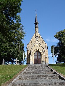
Hemelveerdegem is a village and borough which makes up part of the municipality of Lierde in the Denderstreek in the Belgian province of East Flanders. The village and estate were ruled from 1752 by the armigerous Boelare family.

<span class="mw-page-title-main">Bazel</span> Village in Flemish Region

Bazel is a village in Belgium, in the municipality of Kruibeke in the province of East Flanders. The village is home to the Wissekerke Castle. The municipality of Bazel merged into Kruibeke in 1977.

<span class="mw-page-title-main">Everbeek</span> Village in Flemish Region

Everbeek is a village situated in the Flemish Ardennes and in the Denderstreek in Belgium. In 1977, it was included into the municipality of Brakel. Although it is Dutch speaking, this village was part of the Walloon province of Hainaut (Henegouwen) until 1963, when it became part of the Flemish province of East Flanders.

<span class="mw-page-title-main">Michelbeke</span> Village in Flemish Region

Michelbeke is a village in the municipality of Brakel, Belgium. It is located in the Denderstreek and in the Flemish Ardennes, the hilly southern part of the province of East Flanders, Belgium. It was itself a municipality until the fusion of the municipalities on 1 January 1971.

<span class="mw-page-title-main">Sint-Maria-Oudenhove</span> Village in Flemish Region

Sint-Maria-Oudenhove is a village in the Denderstreek and in the Flemish Ardennes, the hilly southern part of the province of East Flanders, Belgium.

<span class="mw-page-title-main">Opbrakel</span> Village in Flemish Region

Opbrakel is a village and deelgemeente (sub-municipality) of the municipality of Brakel. It is located in the Denderstreek in the province of East Flanders in Belgium. It used to be an independent municipality until 1971 when it was merged into Brakel.

<span class="mw-page-title-main">Parike</span> Village in Flemish Region

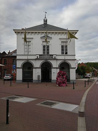
Parike is a village and deelgemeente (sub-municipality) of the municipality of Brakel. It is located in the Denderstreek in the province of East Flanders in Belgium. It used to be an independent municipality until 1977 when it was merged into Brakel.

<span class="mw-page-title-main">Erwetegem</span> Village in Flemish Region

Erwetegem is a village and deelgemeente (sub-municipality) belonging to the municipality of Zottegem. It is located in the Denderstreek and in the Flemish Ardennes, the hilly southern part of the province of East Flanders, Belgium. Erwetegem used to be an independent municipality until 1970.

<span class="mw-page-title-main">Oelegem</span> Village in Flemish Region

Oelegem is a village and deelgemeente (sub-municipality) of the municipality of Ranst in the province of Antwerp, Belgium. The village is located about 14 kilometres (8.7 mi) east of the city of Antwerp.

<span class="mw-page-title-main">Oud-Rekem</span> Village in Flemish Region

Oud-Rekem is a village in the Lanaken municipality of the Limburg province of Belgium. The village is considered one of the most authentic villages of Belgium. Since 1994, it is protected as a monument.

<span class="mw-page-title-main">Kerkom-bij-Sint-Truiden</span> Village in Flemish Community, Belgium

Kerkom-bij-Sint-Truiden is a village in the Sint-Truiden municipality of the Limburg province in the Flemish Community of Belgium. Kerkom-bij-Sint-Truiden was an independent municipality until 1970 when it merged with Borlo. In 1976, the village opted to become part of Sint-Truiden.

<span class="mw-page-title-main">Verrebroek</span> Village in Flemish Region

Verrebroek is a village and deelgemeente in the municipality of Beveren in East Flanders, Belgium. Verrebroek was an independent municipality until 1 January 1977, when it merged with Beveren as part of the fusion of municipalities in Belgium.

<span class="mw-page-title-main">Sleidinge</span> Village in Flemish Region

Sleidinge is a village in the municipalities of Evergem in the province of East Flanders, Belgium. It is located about 10 kilometres (6.2 mi) north-west of Ghent.

<span class="mw-page-title-main">Liezele</span> Village in Flemish Region

Liezele is a village and deelgemeente (sub-municipality) of the municipality of Puurs-Sint-Amands in the province of Antwerp, Belgium. The village is located about 20 kilometres (12 mi) south-south-west of the city of Antwerp. On the night of 4 to 5 September 1914, the entire village was destroyed by the Belgian Army to deny the Germany Army cover.

<span class="mw-page-title-main">Watervliet, Belgium</span> Village in Flemish Region

Watervliet is a village in the Belgian province of East Flanders and suburb of the town of Sint-Laureins. Watervliet is part of the Meetjesland, and is adjacent to the Dutch border. It was a separate municipality until 1977.

<span class="mw-page-title-main">Rutten, Belgium</span> Village and former municipality in Flanders

Rutten is a village in the Tongeren municipality of the Limburg province in the Flemish Community of Belgium. The village is located in the Haspengouw region, and was a separate municipality until its merger into Tongeren in 1977.

<span class="mw-page-title-main">Kallo</span> Village in East Flanders, Belgium

Kallo is a village and deelgemeente (sub-municipality) of Beveren in East Flanders, Belgium. Kallo was an independent municipality until 1 January 1977, when it merged with Beveren as part of the fusion of municipalities in Belgium. Most of the deelgemeente consists of harbours and industrial zones.

<span class="mw-page-title-main">Ruisbroek, Antwerp</span> Village in Flemish Region

Ruisbroek is a village in the municipality of Puurs-Sint-Amands located in the Antwerp Province of Belgium.

<span class="mw-page-title-main">Wortegem</span> Village in Flemish Region

Wortegem is a village and seat of the municipality of Wortegem-Petegem in the Belgian province of East Flanders. It is located about 17 kilometres (11 mi) east of Kortrijk.

<span class="mw-page-title-main">Zegelsem</span> Village in Flemish Region

Zegelsem is a village in the municipality of Brakel in the province of East Flanders, Belgium. Zegelsem is an agricultural community in the Flemish Ardennes. It is located about 26 kilometres (16 mi) south of Ghent.

References

  1. 1 2 "Bevolking per statistische sector - Sector 45059A". Statistics Belgium. Retrieved 4 May 2022. Including Ursel (2,817)
  2. 1 2 3 4 "Nederbrakel". Agentschap Onroerend Erfgoed (in Dutch). Retrieved 21 October 2020.
  3. "Sint-Pieter-in-de-Bandenkerk". Beiaard (in Dutch). Retrieved 21 October 2020.
  4. "Toepkapel". Toepkapel (in Dutch). Retrieved 21 October 2020.
  5. "Nederbrakel". Brakel Toerisme (in Dutch). Retrieved 21 October 2020.
  6. "Brakel". Agentschap Onroerend Erfgoed (in Dutch). Retrieved 21 October 2020.
  7. "JEAN HENRI DE COENE Portrait of a gentleman, half-length, holding his gloves". Sothebys. Retrieved 21 October 2020.
  8. "Voordracht Bert Govaert - uitgesteld tot latere datum! Een lezing over minister Albert De Vleeschauwer tijdens W.O. II". Library of Brakel (in Dutch). Retrieved 21 October 2020.