
Navigation is a field of study that focuses on the process of monitoring and controlling the movement of a craft or vehicle from one place to another. The field of navigation includes four general categories: land navigation, marine navigation, aeronautic navigation, and space navigation.

A nautical chart or hydrographic chart is a graphic representation of a sea region or water body and adjacent coasts or banks. Depending on the scale of the chart, it may show depths of water (bathymetry) and heights of land (topography), natural features of the seabed, details of the coastline, navigational hazards, locations of natural and human-made aids to navigation, information on tides and currents, local details of the Earth's magnetic field, and human-made structures such as harbours, buildings, and bridges. Nautical charts are essential tools for marine navigation; many countries require vessels, especially commercial ships, to carry them. Nautical charting may take the form of charts printed on paper or computerized electronic navigational charts. Recent technologies have made available paper charts which are printed "on demand" with cartographic data that has been downloaded to the commercial printing company as recently as the night before printing. With each daily download, critical data such as Local Notices to Mariners are added to the on-demand chart files so that these charts are up to date at the time of printing.

The United Kingdom Hydrographic Office (UKHO) is the UK's agency for providing hydrographic and marine geospatial data to mariners and maritime organisations across the world. The UKHO is a trading fund of the Ministry of Defence (MoD) and is located in Taunton, Somerset, with a workforce of approximately 900 staff.

The automatic identification system (AIS) is an automatic tracking system that uses transceivers on ships and is used by vessel traffic services (VTS). When satellites are used to receive AIS signatures, the term Satellite-AIS (S-AIS) is used. AIS information supplements marine radar, which continues to be the primary method of collision avoidance for water transport. Although technically and operationally distinct, the ADS-B system is analogous to AIS and performs a similar function for aircraft.
GRIB is a concise data format commonly used in meteorology to store historical and forecast weather data. It is standardized by the World Meteorological Organization's Commission for Basic Systems, known under number GRIB FM 92-IX, described in WMO Manual on Codes No.306. Currently there are three versions of GRIB. Version 0 was used to a limited extent by projects such as TOGA, and is no longer in operational use. The first edition is used operationally worldwide by most meteorological centers, for Numerical Weather Prediction output (NWP). A newer generation has been introduced, known as GRIB second edition, and data is slowly changing over to this format. Some of the second-generation GRIB is used for derived products distributed in the Eumetcast of Meteosat Second Generation. Another example is the NAM model.

Admiralty charts are nautical charts issued by the United Kingdom Hydrographic Office (UKHO) and subject to Crown Copyright. Over 3,500 Standard Nautical Charts (SNCs) and 14,000 Electronic Navigational Charts (ENCs) are available with the Admiralty portfolio offering the widest official coverage of international shipping routes and ports, in varying detail.

An electronic navigational chart (ENC) is an official database created by a national hydrographic office for use with an Electronic Chart Display and Information System (ECDIS). ECDIS and ENCs are the primary means of electronic navigation on cargo ships. Charts can be used in navigation to provide an indication of location once a position is fixed and the charted depths can be used in under keel clearance calculations to ensure the ship is navigating in safe water.
EncFS is a Free (LGPL) FUSE-based cryptographic filesystem. It transparently encrypts files, using an arbitrary directory as storage for the encrypted files.
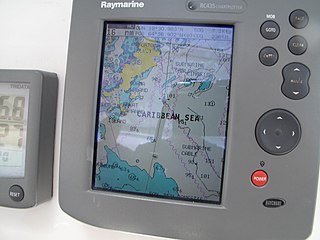
A chartplotter is a device used in marine navigation that integrates GPS data with an electronic navigational chart (ENC).

Electronic Chart Centre AS is Norwegian government enterprise created in 1999 to create and publish nautical charts for use by ships and boats. The company was originally part of Statens Kartverk The Electronic Chart Centre is based in Stavanger and has 15 employees. ECC AS is responsible for the technical operation PRIMAR ENC service in cooperation with Statens Kartverk - sjø.
Navico is a marine electronics company providing navigation, marine instruments and fish finding equipment to both the recreational and commercial marine sectors.
Inland Electronic Navigational Charts (IENC) are electronic navigational charts for rivers, canals, lakes and other inland waters which are navigable. IENCs are displayed by an Inland Electronic Chart Display and Information System.
Satellite navigation software or GNSS navigation software usually falls into one of the following two categories:
- Navigation with route calculation and directions from the software to the user of the route to take, based on a vector-based map, normally for motorized vehicles with some motorized forms added on as an afterthought.
- Navigation tracking, often with a map "picture" in the background, but showing where you have been, and allowing "routes" to be preprogrammed, giving a line you can follow on the screen. This type can also be used for geocaching.

PSPP is a free software application for analysis of sampled data, intended as a free alternative for IBM SPSS Statistics. It has a graphical user interface and conventional command-line interface. It is written in C and uses GNU Scientific Library for its mathematical routines. The name has "no official acronymic expansion".
Marine electronics refers to electronics devices designed and classed for use in the marine environment on board ships and yachts where even a small amount of salt water can destroy some electronics devices. Therefore, the majority of these types of devices are either water resistant or waterproof.

OpenSeaMap is a software project collecting freely usable nautical information and geospatial data to create a worldwide nautical chart. This chart is available on the OpenSeaMap website, and can also be downloaded for use as an electronic chart for offline applications.
Teledyne CARIS, A business unit of Teledyne Digital Imaging, Inc. is a Canadian software company that develops and supports geomatics software for marine and land applications. The company is headquartered in Fredericton, New Brunswick, Canada. CARIS also has offices in the Netherlands, the United States and Australia, and has re-sellers offering sales and support of software products to more than 75 countries.
This article contains a list with gratis satellite navigation software for a range of devices. Some of the free software mentioned here does not have detailed maps or the ability to follow streets or type in street names. However, in many cases, it is also that which makes the program free, avoid the need of an Internet connection, and make it very lightweight. Very basic programs like this may not be suitable for road navigation in cars, but serve their purpose for navigation while walking or trekking, and for use at sea. To determine the GPS coordinates of a destination, one can use sites such as GPScoordinates.eu and GPS visualizer.

The KDE Gear is a set of applications and supporting libraries that are developed by the KDE community, primarily used on Linux-based operating systems but mostly multiplatform, and released on a common release schedule.
The Hydrographic Institute of the Republic of Croatia is a government agency responsible for providing hydrographic and marine geospatial data for the Republic of Croatia. The institute is located in Split, and covers scientific research and development, services related to the safety of navigation, the hydrographic-geodetic survey of the Adriatic sea, marine geodesy, design and publication of nautical charts and books, oceanographic research, and submarine geology research. The Croatian Hydrographic Institute is responsible for the development of navigational safety service in the Adriatic, within the worldwide navigational safety system, and in cooperation with the Ministry of the Sea, Transport and Infrastructure, port authorities, the Croatian Navy, lighthouse authorities, and hydrographic offices of all maritime countries, following internationally agreed standards.
