OpenSeaMap

Last updated
OpenSeaMap
OpenSeaMap-Logo.svg
Type of site
Wiki to create a free world map.
Available inEnglish, German, French, Italian, Spanish, Russian, Arabic
OwnerCommunity
Created bymembers of the OpenSeaMap and OpenStreetMap community
URL map.openseamap.org & openseamap.org
CommercialNo
Registrationonly required for contributors
Launched2009
Content license
CC BY-SA (map), ODbL (data)

OpenSeaMap is a software project collecting freely usable nautical information and geospatial data to create a worldwide nautical chart. This chart is available on the OpenSeaMap website, and can also be downloaded for use as an electronic chart for offline applications. [1]

Contents

The project is part of OpenStreetMap. OpenSeaMap is part of the OpenStreetMap database, and complements the spatial data with nautical information. Such data may be used in accordance with the Open Database License. This ensures integration into printed materials, websites and applications is possible, without being limited by restrictive licenses, or having to pay fees.

History

The idea for the project was born at an OpenStreetMap developer conference in autumn 2008 at the Linux Hotel in Essen, Germany. A group of boaters and programmers decided to extend the coverage of OpenStreetMap to the seas and fresh water bodies. From the start the project has been worldwide and multilingual. By the end of 2009, the design and architecture of the project had been created, and a sample harbor "Warnemünde" was created to serve as an example chart. Since autumn 2009, a dedicated server has been available and the project is engaged in several collaborations with other free projects and organizations. In January 2010, OpenSeaMap was given a booth at boot Düsseldorf, Europe's largest boat show, allowing volunteers to present the project to a large audience of specialists for the first time.

Contents of the chart

OpenSeaMap-Warnemunde.png

Charts will show lighthouses, lateral buoy, cardinal marks and other navigational aids. In the ports, facilities will be mapped (port wall, pier, walkways, docks, fueling stations, loading cranes, access roads, railway lines, ferry lines). Similarly, public authorities, shipbuilders and repairers, as well as sanitation and utility facilities will be displayed. The navigational attributes correspond to the international standard IHO S-57.

Water depths are not yet covered, because the database is not designed for three-dimensional coordinates. However, the plan is to eventually integrate a bathymetric model to describe the seabed.

The data are presented in multiple levels with OpenLayers on the base map of OpenStreetMap. The base map contains all the possible objects from OpenStreetMap. [2] OpenSeaMap includes additional layers such as aids to navigation, ports and temporary racing events.

Applications

The chart is for planning sailing and boat trips. It will also be useful as a guide for tourists. It is not intended to replace official charts.

Online Map
The map is available to any computer with an internet connection from the website OpenSeaMap.org. This map is updated daily.
Offline Map
The map can also be loaded on local data storage and can be used on any PC without internet access. This map will also permit use on other devices, such as GPS devices from Garmin and Lowrance, phones, and PDAs. The off-map is regularly updated, usually every week.
App for iPad, iPhone, iPod touch
The paid App for OpenSeaMap works on iPad, iPhone und iPod touch. [3] The actual position is shown on the chart. Each downloaded chart is cached on the device and can be used without internet connection. With internet connection the app checks if there is a newer version of the chart. The Apple location search finds the fitting map section. The app works worldwide.
Navigation
With certain navigation programs, it is possible to display the current position directly on the chart via a connected GPS device, tracking a vessel's movement. An NMEA interface can run an autopilot and thus control the ship. Also, the display of AIS signals on the chart is possible. Appropriate navigation tools from the open source area are SeaClear, OpenCPN and GPSANGLER.

Internationalization

The site is translated into six languages: English, German, French, Italian, Spanish and Russian. The tools and the legends are available with a German, English and French interface. On the map the place names are always written in local language and script. The geographical coverage is worldwide. Depending on the region and the active cartographers, the coverage varies but is growing daily.

Timelines

Data is stored in the database as soon as it has been entered, and is immediately available worldwide. Base map data is visible on the map after a few minutes. Navigational data is currently (2010) visible on the chart about two days after it has been entered.

Editing tools

JOSM Editor JOSM-ss.png
JOSM Editor
Offline Editor JOSM with navigational enhancements
JOSM is the default editor for OpenStreetMap. It has been extended for use on navigational charts with a plugin. It is written in Java and runs on multiple desktop platforms [4]

To edit you must register with a verified email address. Registration is free and will encourage high data quality. Read access does not require registration.

Other programs can access the XML-RPC interface to the data on the server in order to read and write OpenSeaMap data.

Harbor pilots

The map lists ports, marinas and anchorages. A port guide containing detailed information can be accessed through a popup window. This guide is organized as a Wiki and is shaped by the users. Included is the free wikiproject "SkipperGuide". [5] 5000 ports are accessible worldwide, including detailed descriptions of 600 marinas.

Weather information

Air pressure Wetter Luftdruck.jpg
Air pressure

In worldwide weather charts there are shown weather data like wind speed, air pressure (isobars), etc., each actualised two to three times per day, and with weather forecast up to three days.

For each harbor there is a Meteogram with detailed wind forecasts and weather information for eight days. Available weather data for wind direction, wind speed, air temperature, air pressure, relative humidity, cloudiness, precipitation. From this worldwide available data the captains can predict the marine weather.

Bathymetric data

Bathymetric data GEBCO-Waterdepth-OpenSeaMap-Atlanitct-1024x513.jpg
Bathymetric data

Worldwide, depths between 25 and 10,000 m are shown in a blue colour scale of 26 steps. At higher zoom levels depth contours are also displayed. The data is derived from GEBCO 2021 dataset.

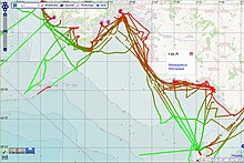
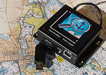
Water depths by crowdsourcing

Depth tracks near Palma (ES) Tiefen-Tracks Palma.jpg
Depth tracks near Palma (ES)
OpenSeaMap Data Logger 15-11-01-Schweriner See-RalfR-WMA 3263.jpg
OpenSeaMap Data Logger

OpenSeaMap measures water depths by Crowdsourcing. Sailors, motor boaters, commercial shipping, divers, fishermen collect water depths between 0 and 100 m with sounder and GPS. Divers work with a dive computer. Coastal water, lakes and rivers are surveyed. Result will be an elevation model and derived depth lines. [1] [6] Uploaded tracks are shown in the chart. [7] There is a discussion how crowdsourcing can support and enrich the systematic official measuring.

Wikipedia articles on the map

OpenSeaMap and Wikipedia OpenSeaMap und Wikipedia.jpg
OpenSeaMap and Wikipedia

By "View Wikipedia-Links" OpenSeaMap displays all georeferenced Wikipedia articles worldwide as Icon, and optionally as gallery of all pictures from Commons. 1.7 million georeferenced articles are shown, in 41 languages, with 260,000 in German and 740,000 in English (as of September 2011). With mouseover, a popup is opened with title of the article and an informative picture. Clicking on the pop-up will get the responding Wikipedia article.

See also

Related Research Articles

<span class="mw-page-title-main">Hydrography</span> Applied science of measurement and description of physical features of bodies of water

Hydrography is the branch of applied sciences which deals with the measurement and description of the physical features of oceans, seas, coastal areas, lakes and rivers, as well as with the prediction of their change over time, for the primary purpose of safety of navigation and in support of all other marine activities, including economic development, security and defense, scientific research, and environmental protection.

<span class="mw-page-title-main">Nautical chart</span> Topographic map of a maritime area and adjacent coastal regions

A nautical chart or hydrographic chart is a graphic representation of a sea region or water body and adjacent coasts or banks. Depending on the scale of the chart, it may show depths of water (bathymetry) and heights of land (topography), natural features of the seabed, details of the coastline, navigational hazards, locations of natural and human-made aids to navigation, information on tides and currents, local details of the Earth's magnetic field, and human-made structures such as harbours, buildings, and bridges. Nautical charts are essential tools for marine navigation; many countries require vessels, especially commercial ships, to carry them. Nautical charting may take the form of charts printed on paper or computerized electronic navigational charts. Recent technologies have made available paper charts which are printed "on demand" with cartographic data that has been downloaded to the commercial printing company as recently as the night before printing. With each daily download, critical data such as Local Notices to Mariners are added to the on-demand chart files so that these charts are up to date at the time of printing.

Piloting or pilotage is the process of navigating on water or in the air using fixed points of reference on the sea or on land, usually with reference to a nautical chart or aeronautical chart to obtain a fix of the position of the vessel or aircraft with respect to a desired course or location. Horizontal fixes of position from known reference points may be obtained by sight or by radar. Vertical position may be obtained by depth sounder to determine depth of the water body below a vessel or by altimeter to determine an aircraft's altitude, from which its distance above the ground can be deduced. Piloting a vessel is usually practiced close to shore or on inland waterways. Pilotage of an aircraft is practiced under visual meteorological conditions for flight.

<span class="mw-page-title-main">Bathymetric chart</span> Map depicting the submerged terrain of bodies of water

A bathymetric chart is a type of isarithmic map that depicts the submerged topography and physiographic features of ocean and sea bottoms. Their primary purpose is to provide detailed depth contours of ocean topography as well as provide the size, shape and distribution of underwater features. Topographic maps display elevation above ground and are complementary to bathymetric charts. Charts use a series of lines and points at equal intervals to showcase depth or elevation. A closed shape with increasingly smaller shapes inside of it can indicate an ocean trench or a seamount, or underwater mountain, depending on whether the depths increase or decrease going inward.

<span class="mw-page-title-main">Google Maps</span> Googles web mapping service (launched 2005)

Google Maps is a web mapping platform and consumer application offered by Google. It offers satellite imagery, aerial photography, street maps, 360° interactive panoramic views of streets, real-time traffic conditions, and route planning for traveling by foot, car, bike, air and public transportation. As of 2020, Google Maps was being used by over one billion people every month around the world.

GRIB is a concise data format commonly used in meteorology to store historical and forecast weather data. It is standardized by the World Meteorological Organization's Commission for Basic Systems, known under number GRIB FM 92-IX, described in WMO Manual on Codes No.306. Currently there are three versions of GRIB. Version 0 was used to a limited extent by projects such as TOGA, and is no longer in operational use. The first edition is used operationally worldwide by most meteorological centers, for Numerical Weather Prediction output (NWP). A newer generation has been introduced, known as GRIB second edition, and data is slowly changing over to this format. Some of the second-generation GRIB are used for derived product distributed in Eumetcast of Meteosat Second Generation. Another example is the NAM model.

<span class="mw-page-title-main">OpenStreetMap</span> Collaborative project to create a free editable map of the world

OpenStreetMap (OSM) is a free, open geographic database updated and maintained by a community of volunteers via open collaboration. Contributors collect data from surveys, trace from aerial imagery and also import from other freely licensed geodata sources. OpenStreetMap is freely licensed under the Open Database License and as a result commonly used to make electronic maps, inform turn-by-turn navigation, assist in humanitarian aid and data visualisation. OpenStreetMap uses its own topology to store geographical features which can then be exported into other GIS file formats. The OpenStreetMap website itself is an online map, geodata search engine and editor.

Global Navigation Satellite System (GNSS) receivers, using the GPS, GLONASS, Galileo or BeiDou system, are used in many applications. The first systems were developed in the 20th century, mainly to help military personnel find their way, but location awareness soon found many civilian applications.

<span class="mw-page-title-main">Satellite navigation device</span> Device that can calculate its geographical position based on satellite information

A satellite navigation device is a user equipment that uses one or more of several global navigation satellite systems (GNSS) to calculate the device's geographical position and provide navigational advice. Depending on the software used, the satnav device may display the position on a map, as geographic coordinates, or may offer routing directions.

<span class="mw-page-title-main">Here Technologies</span> Netherlands-based mapping data company

Here Technologies is an American–Dutch multinational group dealing with mapping, location data and related automotive services to individuals and companies. It is majority-owned by a consortium of German automotive companies and American semiconductor company Intel whilst other companies also own minority stakes. Its roots date back to U.S.-based Navteq in 1985, which was acquired by Finland-based Nokia in 2007. Here is currently based in The Netherlands.

Google Maps Navigation is a mobile application developed by Google for the Android and iOS operating systems that was later integrated into the Google Maps mobile app. The application uses an Internet connection to a GPS navigation system to provide turn-by-turn voice-guided instructions on how to arrive at a given destination. The application requires connection to Internet data and normally uses a GPS satellite connection to determine its location. A user can enter a destination into the application, which will plot a path to it. The app displays the user's progress along the route and issues instructions for each turn.

<span class="mw-page-title-main">Sygic</span> Slovak company

Sygic is a Slovak company of global automotive navigation systems for mobile phones and tablets. The company was founded in 2004 and is headquartered in Bratislava, Slovakia. It became the first company to offer navigation for iPhone and second for Android. In 2015 Sygic reached milestone of 100 million downloads of its navigation app.

<span class="mw-page-title-main">Turn-by-turn navigation</span> Feature of GPS navigation devices

Turn-by-turn navigation is a feature of some satellite navigation devices where directions for a selected route are continually presented to the user in the form of spoken or visual instructions. The system keeps the user up-to-date about the best route to the destination, and is often updated according to changing factors such as traffic and road conditions. Turn-by-turn systems typically use an electronic voice to inform the user whether to turn left or right, the street name, and the distance to the next turn.

<span class="mw-page-title-main">OsmAnd</span> Offline maps & navigation Android and iOS app

OsmAnd is a map and navigation app for Android and iOS. It uses the OpenStreetMap (OSM) map database for its primary displays, but is an independent app not endorsed by the OpenStreetMap Foundation. It is available in both free and paid versions; the latter unlocks the download limit for offline maps and provides access to Wikipedia points of interest (POIs) and their descriptions from within the app. Map data can be stored on the device for offline use. Using the device's GPS capabilities, OsmAnd offers routing, with visual and voice guidance, for car, bike, and pedestrian. All of the main functionalities work both online and offline.

<span class="mw-page-title-main">Moving map display</span>

A moving map display is a type of navigation system output that, instead of numerically displaying the current geographical coordinates determined by the navigation unit or an heading and distance indication of a certain waypoint, displays the unit's current location at the center of a map. As the unit moves around and new coordinates are therefore determined, the map moves to keep its position at the center of the display.

This article contains a list with gratis satellite navigation software for a range of devices. Some of the free software mentioned here does not have detailed maps or the ability to follow streets or type in street names. However, in many cases, it is also that which makes the program free, avoid the need of an Internet connection, and make it very lightweight. Very basic programs like this may not be suitable for road navigation in cars, but serve their purpose for navigation while walking or trekking, and for use at sea. To determine the GPS coordinates of a destination, one can use sites such as GPScoordinates.eu and GPS visualizer.

<span class="mw-page-title-main">Here WeGo</span> Web mapping and navigation service since 2012

Here WeGo is a web mapping and navigation service, operated by HERE Technologies and originally developed by Nokia. In 2013, HERE Technologies released this web mapping application for Windows Phone and the World Wide Web as a revamped version of Nokia Maps. HERE Technologies released the HERE Maps application to the Android platform on December 10, 2014, and later for iOS on March 11, 2015. The company changed the product name to HERE WeGo in July 2016. It is the default maps service provider for the Amazon Fire tablets and smartphones.

<span class="mw-page-title-main">Locus Map</span>

Locus Map is a multi-functional Android navigation app adding advanced online and offline GPS capabilities to Android devices. Primarily it is designed and used for leisure time outdoor activities like hiking, biking, geocaching. Besides its leisure time utilization the app is also used by professionals e.g. for collecting geospatial data, by rescue squad teams, aerial reconnaissance teams etc.

<span class="mw-page-title-main">JOSM</span> Free software desktop editing tool

JOSM(Java OpenStreetMap editor) is a free software desktop editing tool for OpenStreetMap geodata created in Java, originally developed by Immanuel Scholz and currently maintained by Dirk Stöcker. The editing tool contains advanced features that are not present in OSM's default online editor, iD.

Yandex Maps is a Russian web mapping service developed by Yandex. The service provides detailed maps of the whole world, it provides directions and estimated times of arrival for driving, walking, cycling, kick scooter, and public transportation navigation. It includes a search, information about traffic jams, routing and street panoramas. The service was launched in 2004.

References

  1. 1 2 Hydro International: OpenSeaMap - the Free Nautical Chart
  2. map elements "Map Features "
  3. App for OpenSeaMap for iPhone, iPad and iPod touch
  4. JOSM Editor
  5. port manual "SkipperGuide"
  6. OpenSeaMap – Wassertiefen per Crowdsourcing. Hydrographische Nachrichten 95, 30. Jahrgang, Juni 2013, Seiten 23-27.
  7. Water depths by crowd sourcing (Chart)