
The Cuyahoga River is a river located in Northeast Ohio that bisects the City of Cleveland and feeds into Lake Erie.

Tornado, also called Upper Falls, is a census-designated place (CDP) in Kanawha County, West Virginia, United States.

The Cumberland River is a major waterway of the Southern United States. The 688-mile-long (1,107 km) river drains almost 18,000 square miles (47,000 km2) of southern Kentucky and north-central Tennessee. The river flows generally west from a source in the Appalachian Mountains to its confluence with the Ohio River near Paducah, Kentucky, and the mouth of the Tennessee River. Major tributaries include the Obey, Caney Fork, Stones, and Red Rivers.
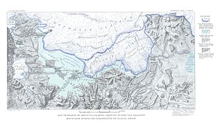
Lake Tear of the Clouds is a small tarn located in the town of Keene, in Essex County, New York, United States, on the southwest slope of Mount Marcy, the state's highest point, in the Adirondack Mountains. It is the highest pond in the state at 4,293 feet (1,309 m). It is often cited as the highest source of the Hudson River, via Feldspar Brook, the Opalescent River and Calamity Brook.
The Black River is a 41.1-mile-long (66.1 km) river on the Upper Peninsula of the U.S. state of Michigan, flowing mostly in Gogebic County into Lake Superior at 46°40′03″N90°02′57″W. Its source at 46°18′54″N90°01′15″W is a boreal wetland on the border with Iron County, Wisconsin. The northern section of the river, 14 miles (23 km) within the boundaries of the Ottawa National Forest, was designated a National Wild and Scenic River in 1992.

Big Chico Creek is a creek in northeastern California that originates near Colby Mountain in Lassen National Park. It flows 46 miles (74 km) to its confluence with the Sacramento River in Butte County. The creek's elevation declines from 5,000 feet (1,500 m) above sea level at its head to 120 feet (37 m) where it joins the Sacramento River, as shown on the Ord Ferry USGS quadrangle. Big Chico Creek forms part of the demarcation between the Sierra Nevada and the Cascade Range.
Ord Bend is a small unincorporated community about 121 feet (37 m) above mean sea level in Glenn County, California. For road traffic, Ord Bend is along State Route 45 between Glenn and Hamilton City. It's about eight miles (13 km) south of Hamilton City. The ZIP Code, shared with Glenn and Bayliss, is 95943. The community is inside area code 530. This area is flagged as rural by the U.S. Census Bureau.

New York State Route 28N (NY 28N) is an east–west state highway in the North Country of New York in the United States. It extends for 50.95 miles (82.00 km) through the Adirondack Mountains from Blue Mountain Lake to North Creek. The route is a northerly alternate route to NY 28 between both locations; as such, it passes through several communities that NY 28 bypasses to the south. The westernmost 10 miles (16 km) of NY 28N overlap with NY 30 through the town of Long Lake. NY 28N and NY 30 split in the hamlet of Long Lake, from where NY 30 heads to the north and NY 28N proceeds eastward through mountainous regions of Adirondack Park.

Mount Baldy is an extinct stratovolcano in eastern Arizona in the United States. With a summit elevation of 11,409 feet (3,477 m), the peak of Mount Baldy rises above the tree line and is left largely bare of vegetation, lending the mountain its current name. The Mount Baldy Wilderness occupies the eastern slope of the mountain and is managed by the Apache-Sitgreaves National Forest.

White River Falls State Park is a state park in north central Oregon. It is located 35 miles (56 km) by road south of The Dalles and 4.5 miles (7.2 km) east of Tygh Valley.

The Cedar River is a 38.5-mile-long (62.0 km) river in the central Adirondacks, in Hamilton County, New York. It rises at the outlet of Cedar Lake in the Town of Arietta and flows northeast into the Town of Lake Pleasant, where it passes through the Cedar River Flow. Continuing northeast and east, it passes through the Town of Indian Lake and remote corners of the Towns of Minerva and Newcomb to join the Hudson River northeast of the hamlet of Indian Lake. The Northville-Placid Trail goes past the Cedar Lakes and along the Cedar River to the flow.
Newcomb Bay is a sheltered bay about 1 mile (1.6 km) in extent, between Clark Peninsula and Bailey Peninsula in the Windmill Islands area.

Clark Peninsula is a rocky peninsula, about 3 km (2 mi) long and wide, lying 5 km (3 mi) north-east of Australia's Casey Station at the north side of Newcomb Bay on the Budd Coast of Wilkes Land in Antarctica.

Newcomb is an unincorporated community in Talbot County, Maryland, United States. Newcomb is located along Maryland Route 33 on the south bank of the Miles River, southeast of St. Michaels. It is located near a tract of land, which was once owned by Talbot County planter Robert Newcome.
The South Branch Penobscot River is a river in Somerset County, Maine. Its source, Penobscot lake, the north end of which at is about 1,000 feet (300 m) from the Canada–United States border in Sandy Bay. This section of the border runs along the height of land separating the watersheds of the Penobscot River and the Monument River, which feeds into the Saint Lawrence River.
Lake Great Falls was a prehistoric proglacial lake which existed in what is now central Montana in the United States between 15,000 BCE and 11,000 BCE. Centered on the modern city of Great Falls, Montana, Glacial Lake Great Falls extended as far north as Cut Bank, Montana, and as far south as Holter Lake. At present-day Great Falls, the Glacial Lake Great Falls reached a depth of 600 feet.

The Bechler River is a remote major river flowing southwest entirely within the confines of Yellowstone National Park to its confluence with the Fall River in the southwest section of the park. The river was named by Frank Bradley, a member of the 1872 Hayden Geological Survey for cartographer and explorer Gustavus R. Bechler, the chief surveyor and mapmaker on the survey. Henry Gannett also a member of the survey claimed that Bechler discovered the river, but trapper Osborne Russell explored the area in 1830.

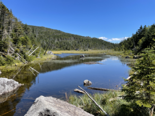
Henderson Lake is a lake in the Adirondack mountains in the town of Newcomb, Essex County, New York in the United States. It was named in 1826 after David Henderson, one of the founders of the Elba Iron Works near Lake Placid, New York, and of the Upper Works at Tahawus, New York. The lake is mainly cited by cartographers as the place where the Hudson River as named officially begins, flowing out of the eastern end and outlet of the lake. Unofficially, the source of the river is traced up Indian Pass Brook and other watercourses to Lake Tear of the Clouds.

Deep Creek is a tributary of the Mojave River, 23.4 miles (37.7 km) long, in San Bernardino County, California.


