U.S. Route 97 is a major north–south United States highway in the western United States built in 1926. It begins at a junction with Interstate 5 at Weed, California, and travels north, ending in Oroville in Okanogan County, Washington, at the Canada–US border, across from Osoyoos, British Columbia, becoming British Columbia Highway 97 upon entering Canada. Major cities that lie on US 97 include Klamath Falls, Bend, and Redmond in Oregon and Yakima, Ellensburg, and Wenatchee in Washington. A portion of the highway in California and Oregon is part of the Volcanic Legacy Scenic Byway.
U.S. Route 201 is part of the nationwide system of United States Numbered Highways. It runs for 157.46 miles (253.41 km) entirely within the state of Maine and is a spur route of U.S. Route 1. Its southern terminus is in Brunswick at US 1 and Maine State Route 24 Business. Its northern terminus is at the Canada–US border near Jackman, where it connects to Quebec Route 173.
Minnesota State Highway 61 is a 148.843-mile-long (239.540 km) highway in northeast Minnesota, which runs from a junction with Interstate 35 (I-35) in Duluth at 26th Avenue East, and continues northeast to its northern terminus at the Canadian border near Grand Portage, connecting to Ontario Highway 61 at the Pigeon River Bridge. The route is a scenic highway, following the North Shore of Lake Superior, and is part of the Lake Superior Circle Tour designation that runs through Minnesota, Ontario, Michigan, and Wisconsin.
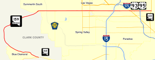
State Route 159 is a 31.204-mile (50.218 km) east–west highway in Clark County, Nevada, United States, providing access to Red Rock Canyon and serving as a thoroughfare in the Las Vegas metropolitan area. A portion of the west end of the route is designated a Nevada Scenic Byway.

State Highway 7 is an 81.64 miles (131.39 km) long state highway in the U.S. state of Colorado. It is located in the north-central portion of the state, traversing the mountains on the east of the continental divide south of Estes Park as well as portions of the Colorado Piedmont north of Denver. The northwestern segment of the highway is part of the Peak-to-Peak Scenic Byway and furnishes an access route to Estes Park, Colorado and Rocky Mountain National Park. In its southeast portion it skirts the northern end of the Denver Metropolitan Area, providing an access route connecting Boulder, Lafayette and Brighton with Interstate 25 and Interstate 76.
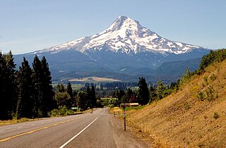
The Mount Hood Highway No. 26 is the Oregon Department of Transportation's designation for a 96.74-mile-long (155.69 km) highway from Portland east around the south side of Mount Hood and north via Bennett Pass to Hood River. It is marked as U.S. Route 26 from Portland to near Mount Hood and Oregon Route 35 the rest of the way to Hood River.

State Route 261 is a state highway located entirely within south-central San Juan County, Utah. It runs 34 miles (55 km) north, from the junction of U.S. Route 163, to the junction with State Route 95, just east of Natural Bridges National Monument.

Highway 16 is an east–west state highway in Arkansas. The route begins in Siloam Springs at US Highway 412 (US 412) and Highway 59 and runs east through Fayetteville and the Ozark National Forest to US Highway 67 Business (US 67B) in Searcy. Highway 16 was created during the 1926 Arkansas state highway numbering, and today serves as a narrow, winding, 2-lane road except for overlaps of 10 miles (16 km) through Fayetteville. Much of the highway winds through the Ozarks, including the Ozark National Forest, where a portion of the highway is designated as an Arkansas Scenic Byway. The route has two spur routes in Northwest Arkansas; in Fayetteville and Siloam Springs.

Highway 21 is a north–south state highway in north central Arkansas. The route of 99.14 miles (159.55 km) runs from US Route 64 (US 64) in Clarksville north across US 62 to Missouri Route 13 at the Missouri state line The route is a two-lane highway with the exception of a brief concurrency with US 62, a four-lane highway, in Berryville.
State Trunk Highway 42 is a state highway in the U.S. state of Wisconsin. It runs for about 138 miles (222 km) north–south in northeast Wisconsin from Sheboygan to the ferry dock in Northport. Much of the highway is part of the Lake Michigan Circle Tour from the eastern junction with U.S. Highway 10 (US 10) in Manitowoc to its junction with WIS 57 in Sister Bay. WIS 42 parallels I-43 from Sheboygan to Manitowoc, and parallels WIS 57 throughout much of the route, particularly from Manitowoc to Sturgeon Bay, meeting the northern terminus of WIS 57 in Sister Bay.
New York State Route 12E (NY 12E) is a state highway located entirely within the northwestern part of Jefferson County in northern New York in the United States. The southern terminus is at NY 12F in the village of Brownville. Its northern terminus, both signed and official, is at NY 12 in the village of Clayton. While NY 12 follows a direct north–south routing between Watertown and Clayton, NY 12E diverges westward to follow the shoreline of Lake Ontario. The portion of NY 12E north of its junction with NY 180 is part of the Seaway Trail, a National Scenic Byway.

State Highway 55 (SH-55) is an Idaho highway from Marsing to New Meadows, connecting with US-95 at both ends.
State Highway 69 (SH-69) is a short 8.012-mile-long (12.894 km) state highway in the U.S. state of Idaho. It runs from Kuna to Interstate 84 (I-84) in Meridian.

The Dinosaur Diamond Prehistoric Highway is a 512-mile-long (824 km) National Scenic Byway in the U.S. states of Utah and Colorado. The highway forms a diamond-shaped loop with vertices at Moab, Helper, Vernal and Grand Junction.

State Highway 75 is a two-lane highway that travels through the Sawtooth Valley of central Idaho. The highway's southern terminus is in Shoshone, and its northern is near Challis. It is designated as one of Idaho's scenic byways and provides access to Sawtooth National Recreation Area. It primarily follows the Big Wood River in the south and the main Salmon River in the north, divided by Galena Summit.
U.S. Highway 136 is a part of the United States Numbered Highway System that runs for 804 miles (1,294 km) between Edison, Nebraska and Speedway, Indiana. It is a spur route of US 36 despite never intersecting its parent. Within the State of Nebraska it is a state highway that begins at a junction with US 6 and US 34 north of Edison and travels east across the southern part of the state to the Nebraska–Missouri state line in Brownville along the banks of the Missouri River. Throughout its 239.88-mile (386.05 km) length, the highway is known as the Heritage Highway, one of nine scenic byways in the state. The highway travels across the grassland prairies of southern Nebraska to the woods of the Missouri River Valley encountering winding rivers, farmlands, and historic settlements. These landscapes were featured in stories from Pulitzer Prize-winning author Willa Cather recounting life on the Nebraska Plains during the end of the 19th century. For its entire length, US 136 is a two-lane highway with the exception of a 0.51-mile (0.82 km) stretch of divided highway within Fairbury.

Arkansas Highway 309 is a designation for two state highways in Western Arkansas. One route of 5.11 miles (8.22 km) runs from Yell County Route 28 (CR 28) at Blue Mountain Lake northeast to Highway 10 at Waveland. A second segment begins at Highway 10 in Havana and winds northwest through the Ozark National Forest to Highway 23 at Webb City via Paris. A portion of the second route is designated as the Mount Magazine Scenic Byway, one of eleven Arkansas Scenic Byways maintained by the Arkansas State Highway and Transportation Department (AHTD).
State Route 153 (SR-153) is a state highway in the U.S. state of Utah. Just over half of the western portion of the highway has been designated the Beaver Canyon Scenic Byway as part of the Utah Scenic Byways and National Forest Scenic Byways programs.
State Highway 65 (SH 65) is a state highway in Colorado that crosses the Grand Mesa. The highway along with a road to Lands End Overlook were designated as the Grand Mesa Scenic and Historic Byway in 1996. SH 65's southern terminus is at SH 92 east of Delta, and its northern terminus is at Interstate 70 (I-70) and U.S. Route 6 (US 6) northeast of Palisade.

Journey Through Time Scenic Byway is a scenic byway in the U.S. state of Oregon. It spans five Oregon counties and comprises portions of U.S. Route 97, Oregon Route 218, Oregon Route 19, U.S. Route 26, and Oregon Route 7. The John Day River meanders through much of its route. The byway offers glimpses into the geologic and pioneer history of Oregon.


