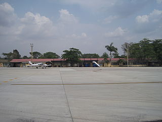
Orocue Airport

Last updated
Orocue Airport
Summary
Airport type Public
Serves Orocué, Colombia
Elevation  AMSL 434 ft / 132 m
Coordinates 4°47′24″N71°20′55″W / 4.79000°N 71.34861°W / 4.79000; -71.34861
Map
Colombia location map.svg
Airplane silhouette.svg
ORC
Location of airport in Colombia
Runways
Direction Length Surface
m ft
05/23 1,548 5,079 Asphalt
Source: [1] Google Maps [2]

Orocue Airport( IATA : ORC, ICAO : SKOE) is an airport serving Orocué, a town and municipality in the Casanare Department of Colombia. The runway is adjacent to the western edge of the town, north of the Meta River.

An IATA airport code, also known as an IATA location identifier, IATA station code or simply a location identifier, is a three-letter code designating many airports around the world, defined by the International Air Transport Association (IATA). The characters prominently displayed on baggage tags attached at airport check-in desks are an example of a way these codes are used.

ICAO airport code four-letter code designating many airports around the world

The ICAOairport code or location indicator is a four-letter code designating aerodromes around the world. These codes, as defined by the International Civil Aviation Organization and published in ICAO Document 7910: Location Indicators, are used by air traffic control and airline operations such as flight planning.

Airport location where aircraft take off and land

An airport is an aerodrome with extended facilities, mostly for commercial air transport. Airports often have facilities to store and maintain aircraft, and a control tower. An airport consists of a landing area, which comprises an aerially accessible open space including at least one operationally active surface such as a runway for a plane to take off or a helipad, and often includes adjacent utility buildings such as control towers, hangars and terminals. Larger airports may have airport aprons, taxiway bridges, air traffic control centres, passenger facilities such as restaurants and lounges, and emergency services. In some countries, the US in particular, they also typically have one or more fixed-base operators, serving general aviation.

Contents

The Carimauga non-directional beacon (Ident: CRG) is 13.3 nautical miles (24.6 km; 15.3 mi) south of the airport. [3]

Non-directional beacon radio transmitter which emits radio waves in all directions

A non-directional (radio) beacon (NDB) is a radio transmitter at a known location, used as an aviation or marine navigational aid. As the name implies, the signal transmitted does not include inherent directional information, in contrast to other navigational aids such as low frequency radio range, VHF omnidirectional range (VOR) and TACAN. NDB signals follow the curvature of the Earth, so they can be received at much greater distances at lower altitudes, a major advantage over VOR. However, NDB signals are also affected more by atmospheric conditions, mountainous terrain, coastal refraction and electrical storms, particularly at long range.

See also

Transport in Colombia

Transport in Colombia is regulated by the Ministry of Transport.

Related Research Articles

El Edén International Airport airport in La Tebaida, Quindío, Colombia

El Edén International Airport is an international airport serving Armenia, the capital of the Quindío Department of Colombia. The airport is 13 kilometres (8.1 mi) southwest of Armenia, near the town of La Tebaida. It handles domestic flights to Bogotá and Medellín and international flights to Panama City and Fort Lauderdale, Florida.

Orc or ORC may refer to:

Alcides Fernández Airport airport in colombia

Alcides Fernández Airport is a commercial airport on the Caribbean coast serving to town of Acandí in the Choco Department of Colombia. The airport is considered by residents of the town of Acandí to be an important link between that community and the rest of Colombia as well as neighboring Panama.

La Vanguardia Airport airport in Colombia

La Vanguardia Airport is an airport serving the city of Villavicencio in the Meta Department of Colombia. It serves regular passenger, charter and cargo airlines as well as private sectors.

Puerto Bolívar Airport airport in Uribia, Colombia

Puerto Bolívar Airport is a private airport in the Guajira Department of Colombia. The closest city is Uribia. It is located next to the Cerrejón coal terminal and only serves the workers of the area. Only private sector aircraft and Colombia's Aerocivil land at Puerto Bolivar. No commercial airlines serve the airport and it is mostly empty.

Orocué Municipality and town in Orinoquía Region, Colombia

Orocué is a town and municipality in the Department of Casanare, Colombia, located on the shore of the Meta River. Historically, it went by the name San Miguel del Macuco.

Guaymaral Airport airport in Colombia

Guaymaral Airport is a high-elevation airport in the north of Bogotá, Colombia, also serving the towns of Cota and Chía. The runway is 15 kilometres (9.3 mi) northeast of Bogota's El Dorado International Airport.

Antonio Nariño Airport colombian airport

Antonio Nariño Airport is located in the town of Chachagüí and serves the city of Pasto in the Nariño Department of Colombia. The airport is 35 kilometres (22 mi) north of Pasto. It handles only domestic flights in addition to military operations and private charters. A new terminal, administrative and tower control are being built, also new navigation equipment is being set up due to the increasing number of passengers and cargo flights.

Yariguíes Airport airport in Barrancabermeja, Colombia

Yariguíes Airport is an airport serving Barrancabermeja, a city in the Santander Department of Colombia. The airport is 6 kilometres (3.7 mi) southeast of the city.

Antonio Roldán Betancourt Airport airport in Colombia

Antonio Roldán Betancourt Airport is an airport serving Apartadó, a town in the Antioquia Department of Colombia. The airport is in the countryside 12 kilometres (7.5 mi) southwest of Apartadó.

Las Brujas Airport (Colombia) Colombian domestic airport

The Las Brujas Airport is a domestic airport located in the town of Corozal, Sucre in Colombia. The airport is located 10 minutes from the capital of the department, the city of Sincelejo. In emergency situations, it serves as the alternate airport of the city of Montería. It has regional and national operations. Las Brujas operates regional and domestic flights to Barranquilla, Bogota and Medellin.

Tres de Mayo Airport colombian airport

Tres de Mayo Airport is an airport serving the town of Puerto Asís in the Putumayo District of Colombia.

César Gaviria Trujillo Airport airport

César Gaviria Trujillo Airport is an airport serving the town of Inírida in the Guainía Department of Colombia. The airport is named in honor of César Gaviria Trujillo, a former President of Colombia and Secretary General of the Organization of American States.

Caucayá Airport airport in Colombia

Caucayá Airport is an airport serving the river town of Puerto Leguízamo in the Putumayo Department of Colombia. Puerto Leguízamo is on the Putumayo River, locally the border with Peru.

Jorge Enrique González Torres Airport airport serving San José del Guaviare, the capital of the Guaviare Department of Colombia

Jorge Enrique González Torres Airport is an airport serving San José del Guaviare, the capital of the Guaviare Department of Colombia. The runway is just north of the town and parallels the Guaviare River.

Orange City Municipal Airport airport in Iowa, United States of America

Orange City Municipal Airport is a city-owned public-use airport located one nautical mile (1.85 km) south of the central business district of Orange City, a city in Sioux County, Iowa, United States. This airport is included in the FAA's National Plan of Integrated Airport Systems for 2009–2013, which categorized it as a general aviation facility.

Miraflores Airport airport in Colombia

Miraflores Airport is an airport serving the town of Miraflores, in the Guaviare Department of Colombia. The runway and town are on the east bank of the Vaupés River, a tributary of the Rio Negro River.

Mandinga Airport airport in Colombia

Mandinga Airport is an airport serving the platinum mining town of Condoto in the Chocó Department of Colombia.

Carimagua Airport airport in Colombia

Carimagua Airport is an airport serving the village of Carimagua in the Meta Department of Colombia. The runway is 24 kilometres (15 mi) south of Orocué, the nearest town.

Sardinas Airport airport in Colombia

Sardinas Airport is an airport serving one of the many oil production facilities in the Casanare Department of Colombia. The nearest population center is Orocué, 28 kilometres (17 mi) southeast of the runway.

References

The Aviation Safety Network (ASN) is a website that keeps track of aviation accidents, incidents, and hijackings. Their database contains details of over 10,700 reports. The ASN includes an aviation database with aviation investigations, news, photos, and statistics.