
The Niger Delta Basin, also referred to as the Niger Delta province, is an extensional rift basin located in the Niger Delta and the Gulf of Guinea on the passive continental margin near the western coast of Nigeria with suspected or proven access to Cameroon, Equatorial Guinea and São Tomé and Príncipe. This basin is very complex, and it carries high economic value as it contains a very productive petroleum system. The Niger delta basin is one of the largest subaerial basins in Africa. It has a subaerial area of about 75,000 km2, a total area of 300,000 km2, and a sediment fill of 500,000 km3. The sediment fill has a depth between 9–12 km. It is composed of several different geologic formations that indicate how this basin could have formed, as well as the regional and large scale tectonics of the area. The Niger Delta Basin is an extensional basin surrounded by many other basins in the area that all formed from similar processes. The Niger Delta Basin lies in the south westernmost part of a larger tectonic structure, the Benue Trough. The other side of the basin is bounded by the Cameroon Volcanic Line and the transform passive continental margin.
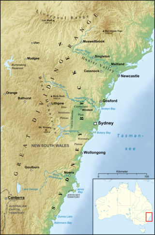
The Sydney Basin is an interim Australian bioregion and is both a structural entity and a depositional area, now preserved on the east coast of New South Wales, Australia and with some of its eastern side now subsided beneath the Tasman Sea. The basin is named for the city of Sydney, on which it is centred.
Abagana is a town in Nigeria. It is the headquarters of Njikoka Local Government Area Anambra State and lies approximately 20 kilometers from Onitsha along the old Enugu-Onitsha Trunk A Road that divides the town into two halves.
Nkpor is a town in Idemili North local government area of Anambra state. The town of Nkpor had an estimated population of 109,377 in 2007. It is attached to the much larger city of Onitsha to the west, Oze to the north, Ogidi and Umuoji to the east, and Obosi to the south. The name 'Nkpor' is derived from the adulteration of the Igbo word nkpogha meaning 'repositioning'.Nkpor is known for its farming prowess. There is a maize known as ‘akpu aka Nkpor’ because of its robust yield and is reminiscent of Nkpor men who are often muscular. In ancient times, a rich man is known in Nkpor for his rich yam barn and the number of animals in his pen. An average Nkpor indigene does not buy foodstuff in the market and does not deny his visitors food. Nkpor is a traditional Community that worshiped the God of their ancestors before the advent of Christianity.

The Cumberland Plain, also known as Cumberland Basin, is a relatively flat region lying to the west of Sydney CBD in New South Wales, Australia. An IBRA biogeographic region, Cumberland Basin is the preferred physiographic and geological term for the low-lying plain of the Permian-Triassic Sydney Basin found between Sydney and the Blue Mountains, and it is a structural sub-basin of the Sydney Basin.

The San Juan Basin is a geologic structural basin located near the Four Corners region of the Southwestern United States. The basin covers 7,500 square miles and resides in northwestern New Mexico, southwestern Colorado, and parts of Utah and Arizona. Specifically, the basin occupies space in the San Juan, Rio Arriba, Sandoval, and McKinley counties in New Mexico, and La Plata and Archuleta counties in Colorado. The basin extends roughly 100 miles (160 km) N-S and 90 miles (140 km) E-W.

The Dakota is a sedimentary geologic unit name of formation and group rank in Midwestern North America. The Dakota units are generally composed of sandstones, mudstones, clays, and shales deposited in the Mid-Cretaceous opening of the Western Interior Seaway. The usage of the name Dakota for this particular Albian-Cenomanian strata is exceptionally widespread; from British Columbia and Alberta to Montana and Wisconsin to Colorado and Kansas to Utah and Arizona. It is famous for producing massive colorful rock formations in the Rocky Mountains and the Great Plains of the United States, and for preserving both dinosaur footprints and early deciduous tree leaves.

The Wianamatta Group is a geological feature of the Sydney Basin, New South Wales, Australia that directly overlies the older Hawkesbury sandstone and generally comprise fine grained sedimentary rocks such as shales and laminites as well as less common sandstone units.
Orumba South is a Local Government Area in Anambra State, south-eastern Nigeria. Umunze is the headquarters of Orumba South. Other towns that make up the local government are Akpujiogu (Akpu), Umuomaku, Eziagu, Ezira, Ihite, Nkerehi (Umuchukwu), Nawfija, Ogboji, Ogbunka, Owerre-Ezukala, Agbudu, Onneh, Isulo, and Enugwu-Umuonyia.
Dunukofia is a Local Government Area in Anambra State, South-East Nigeria. Towns that make up the local government are Ukpo, the headquarters; Ifitedunu, Dunukofia Umunnachi, Umudioka, Ukwulu and Nawgu. It shares boundaries with Awka North, Idemili North, Njikoka and Oyi Local Governments.
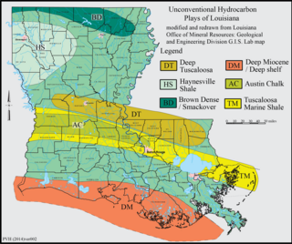
The Haynesville Shale is an informal, popular name for a Jurassic Period rock formation that underlies large parts of southwestern Arkansas, northwest Louisiana, and East Texas. It lies at depths of 10,500 to 13,000 feet below the land’s surface. It is part of a large rock formation which is known by geologists as the Haynesville Formation. The Haynesville Shale underlies an area of about 9,000 square miles and averages about 200 to 300 feet thick. The Haynesville Shale is overlain by sandstone of the Cotton Valley Group and underlain by limestone of the Smackover Formation.
Awgu is the Headquarters of Awgu Local Government Area (LGA) in Enugu State, Nigeria and the Headquarters of Awgu Catholic Diocese. The Catholic Cathedral is said to resemble a space ship when viewed with Google Earth. The town is also the Orientation Training Centre for National Youth Service corps members posted to Enugu State. Geographically, Awgu LGA is located approximately between latitudes 06 00’ and 06 19’ North of the Equator and longitudes 07 23’ and 07 35’ East of the Greenwich Meridian. Awgu LGA is bounded in the north by Udi and Nkanu West LGAs, in the west by Oji River LGA, Aninri LGA and Ivo LGA of Ebonyi State in the East and share border with umunneochi L.G.A of Abia State in the south. The name of the Traditional ruler is Egbeleli. The market is known as Orie Awgu.

The Ozark Highlands is a Level III ecoregion designated by the Environmental Protection Agency (EPA) in four U.S. states. Most of the region is within Missouri, with a part in Arkansas and small sections in Oklahoma and Kansas. It is the largest subdivision of the region known as the Ozark Mountains, less rugged in comparison to the Boston Mountains in Arkansas, the highest part of the Ozarks.

The Cheltenham Badlands are in Caledon, Ontario, on the southeast side of Olde Base Line Road, between Creditview and Chinguacousy Roads. The site occupies an area of approximately 0.4 square kilometers and features exposed and highly eroded Queenston shale. The Cheltenham Badlands are a significant educational site due to the readily visible geologic processes and the red colour and the unique topography of the exposed shale make this a popular tourist site. The site is a Provincial Earth Sciences Area of Natural and Scientific Interest (ANSI) since it is considered one of the best examples of "badlands topography" in Ontario.

The Cozy Dell Shale is a geologic formation of middle Eocene age that crops out in the Santa Ynez Mountains and Topatopa Mountains of California, extending from north of Fillmore in Ventura County westward to near Point Arguello, north of Santa Barbara. Because the Cozy Dell easily weathers to a clay-rich soil, it crops out infrequently and generally forms dense stands of chaparral in saddles between peaks and ridges of the more resistant Matilija and Coldwater formations.
Ukwulu is a town in Dunukofia Local Government Area (LGA) of Anambra State, Nigeria. It is located 13.7 kilometres by road north of the LGA headquarters. It is home to the Igbo peoples.
Osina is a town in Ideato North Local Government of Imo State, Nigeria and is under Orlu senatorial zone. Osina has four villages: Eluama, Uhualla, Ofeke, Umuduru/Umuogbu (Durunogbu). The Nnewi – Okigwe road passes through Osina. The Awka – Umuahia road also passes through Osina.
The geology of Nigeria formed beginning in the Archean and Proterozoic eons of the Precambrian. The country forms the Nigerian Province and more than half of its surface is igneous and metamorphic crystalline basement rock from the Precambrian. Between 2.9 billion and 500 million years ago, Nigeria was affected by three major orogeny mountain-building events and related igneous intrusions. Following the Pan-African orogeny, in the Cambrian at the time that multi-cellular life proliferated, Nigeria began to experience regional sedimentation and witnessed new igneous intrusions. By the Cretaceous period of the late Mesozoic, massive sedimentation was underway in different basins, due to a large marine transgression. By the Eocene, in the Cenozoic, the region returned to terrestrial conditions.
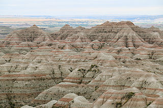
The geology of South Dakota began to form more than 2.5 billion years ago in the Archean eon of the Precambrian. Igneous crystalline basement rock continued to emplace through the Proterozoic, interspersed with sediments and volcanic materials. Large limestone and shale deposits formed during the Paleozoic, during prevalent shallow marine conditions, followed by red beds during terrestrial conditions in the Triassic. The Western Interior Seaway flooded the region, creating vast shale, chalk and coal beds in the Cretaceous as the Laramide orogeny began to form the Rocky Mountains. The Black Hills were uplifted in the early Cenozoic, followed by long-running periods of erosion, sediment deposition and volcanic ash fall, forming the Badlands and storing marine and mammal fossils. Much of the state's landscape was reworked during several phases of glaciation in the Pleistocene. South Dakota has extensive mineral resources in the Black Hills and some oil and gas extraction in the Williston Basin. The Homestake Mine, active until 2002, was a major gold mine that reached up to 8000 feet underground and is now used for dark matter and neutrino research.
