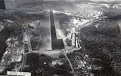
Orote Field

Last updated
Orote Field
Orote Field.jpg
Orote Field in 1945
USA Guam location map.svg
Red pog.svg
Location Orote Peninsula, Naval Base Guam
Nearest city Santa Rita, Guam
Coordinates 13°26′13″N144°38′30″E / 13.43694°N 144.64167°E / 13.43694; 144.64167 Coordinates: 13°26′13″N144°38′30″E / 13.43694°N 144.64167°E / 13.43694; 144.64167
Built1943
NRHP reference No. 75002149 [1]
Added to NRHPJune 18, 1975

Orote Field is a former air base in the United States territory of Guam built by the Empire of Japan with Chamorro forced labor during the Japanese occupation of Guam (1941-1944). It is separate from the Marine Corps amphibious airplane base at located at Sumay village that was operational from 1921 to 1931. Following the liberation of Guam in 1944, the U.S. military repaired the field for further use in the Pacific War. Located on Naval Base Guam, Orote Field was largely abandoned after World War II except for occasional training exercises. One major event in 1975 was Operation New Life, when a tent city for tens of thousands of South Vietnamese refugees was erected at the field. The field was listed on the National Register of Historic Places in 1975.

Contents

History

On August 6, 1941, Naval Governor George McMillin sent a letter reporting surveys indicating that the Orote Peninsula could sustain a 4500-by-400 foot landplane runway. However, the U.S. did not actually start construction of such a runway. However, the Japanese also recognized the suitability of the location. [2] :345 During the Japanese occupation of Guam, villages were required to supply levies of able bodied men to work on airfields and other defense projects. Orote Field was the first of the Japanese airfields on Guam to be completed by Chamorro laborers, largely by hand, in 1943. [3]

From May 1944 through the second Battle of Guam, the airfield was attacked from the air and American troops established their beachhead on either side of the Orote Peninsula on July 21 in order to seize the airfield and the adjacent deep water Apra Harbor. The airfield was recaptured by July 30. [4] At that time the Seabees of the 3d Battalion 19th MarinesLLP (25th Naval Construction Battalion) got the airfield operational. The airfield was one of many U.S. airfields on Guam during the Pacific War, and was closed permanently in 1946. It still sees some use as a touch-and-go training strip used by C-130 Hercules crews located nearby on Andersen Air Force Base. [5] [6]

The old airfield was used to house 50,000 evacuees from South Vietnam during Operation New Life in 1975 [7] and was used as a tent city for the 1999 Tandem Thrust military exercise.

It is now part of Naval Base Guam.

Related Research Articles

Apra Harbor

Apra Harbor, also called Port Apra, is a deep-water port on the western side of the United States territory of Guam. It is considered one of the best natural ports in the Pacific Ocean. The harbor is bounded by Cabras Island and the Glass Breakwater to the north and the Orote Peninsula in the south. Naval Base Guam and the Port of Guam are the two major users of the harbor. It is also a popular recreation area for boaters, surfers, scuba divers, and other recreationalists.

Battle of Tinian

The Battle of Tinian was a battle of the Pacific campaign of World War II, fought on the island of Tinian in the Mariana Islands from 24 July until 1 August 1944. The 8,000-man Japanese garrison was eliminated, and the island joined Saipan and Guam as a base for the Twentieth Air Force.

Battle of Guam (1944) WWII battle by US forces to recapture Guam from the Empire of Japan

The Battle of Guam was the American recapture of the Japanese-held island of Guam, a U.S. territory in the Mariana Islands captured by the Japanese from the U.S. in the 1941 First Battle of Guam during the Pacific campaign of World War II. The battle was critical component of Operation Forager. The recapture of Guam and the broader Mariana and Palau Islands campaign resulted in the destruction of much Japan's naval air power at the Battle of the Philippine Sea and allowed the United States to establish large airbases from which it could bomb the Japanese home islands with its new strategic bomber, the Boeing B-29 Superfortress.

Andersen Air Force Base United States Air Force base in Guam

Andersen Air Force Base is a United States Air Force base located primarily within the village of Yigo in the United States territory of Guam. The host unit at Andersen AFB is the 36th Wing, assigned to the Pacific Air Forces Eleventh Air Force. As a non-flying wing, the 36 WG's mission is to provide support to deployed air and space forces of USAF, foreign air forces to Andersen, and tenant units assigned to the base. Andersen AFB was placed under the installation management authority of Joint Region Marianas on 1 October 2009, along with Naval Base Guam. The two bases are about 30 miles (48 km) apart at opposite ends of the island. Established in 1944 after the Liberation of Guam as North Field, it is named for Brigadier General James Roy Andersen (1904–1945).

Asan-Maina, Guam Village in Guam, United States

Asan-Maina is a village located on the western shore of the United States territory of Guam. The municipality combines the names of the coastal community of Asan with Maina, a community along the slopes of the Fonte River valley to the east. Asan was the northern landing site for United States Marines during Guam's liberation from the Japanese during World War II. Asan Beach Park is part of the War in the Pacific National Historic Park. The third community comprising Asan-Maina is Nimitz Hill Annex in the hills above Asan and Maina, which is the location of the Joint Region Marianas headquarters. Asan-Maina is located in the Luchan (Western) District.

Piti, Guam Village in Guam, United States

Piti is a village located on the central west coast of the United States territory of Guam. It contains northern and eastern coastlines of Apra Harbor, including Cabras Island, which has the commercial Port of Guam and the island's largest power plants. Piti was a pre-Spanish CHamoru village and, after Spanish colonization, became the primary port town on Guam. The town was largely destroyed during the 1944 liberation of Guam and the population relocated during the wartime construction of Apra Harbor.

War in the Pacific National Historical Park

The War in the Pacific National Historical Park is a multi-unit protected area in the United States territory of Guam, which was established in 1978 in honor of those who participated in the Pacific Theater of World War II. Uniquely among the National Park System, it honors the bravery and sacrifices of all those who participated in the Pacific Theater.

Operation New Life American military evacuation operation for Vietnamese refugees through Guam

Operation New Life was the care and processing on Guam of Vietnamese refugees evacuated before and after the Fall of Saigon, the closing day of the Vietnam War. More than 111,000 of the evacuated 130,000 Vietnamese refugees were transported to Guam where they were housed in tent cities for a few weeks while being processed for resettlement. The great majority of the refugees were resettled in the United States. A few thousand were resettled in other countries or chose to return to Vietnam on the vessel Thuong Tin.

Battle of Guam (1941)

The Battle of Guam was an engagement during the Pacific War in World War II, and took place from 8 December to 10 December 1941 on Guam in the Mariana Islands between Japan and the United States. The American garrison was defeated by Japanese forces on 10 December, which resulted in an occupation until the Second Battle of Guam in 1944.

Japanese occupation of Guam

The Japanese occupation of Guam was the period in the history of Guam between 1941 and 1944 when Imperial Japanese forces occupied Guam during World War II. The island was renamed Ōmiya-Jima.

Naval Base Guam US naval base in Guam

Naval Base Guam is a strategic U.S. naval base located on Apra Harbor and occupying the Orote Peninsula. In 2009, it was combined with Andersen Air Force Base, to form Joint Region Marianas, which is a Navy-controlled joint base.

Naval Mobile Construction Battalion 4 Military unit

Naval Mobile Construction Battalion 4 is a Navy Seabee battalion homeported at Port Hueneme, California. Nicknamed the "Pioneers", it is the first of the many CBs created after the original three. The Battalion's current insignia first appeared on its 1953–55 cruisebook.

Orote Peninsula

The Orote Peninsula is a four kilometer-long peninsula jutting from the west coast of the United States territory of Guam. A major geologic feature of the island, it forms the southern coast of Apra Harbor and the northern coast of Agat Bay. Its tip, Point Udall, is Guam's westernmost point and also the United States' westernmost point by travel, not longitude. The peninsula historically was the site of the important Chamorro village of Sumay, as well as Fort Santiago of the Spanish colonial period. In modern times, the peninsula is politically in the village of Santa Rita, but it is controlled in its entirety by Naval Base Guam.

North Field (Tinian) Former World War II airfield on Tinian in the Mariana Islands

North Field is a former World War II airfield on Tinian in the Mariana Islands. Abandoned after the war, today North Field is a tourist attraction. Along with several adjacent beaches on which Allied forces landed during the Battle of Tinian, the airfield is the major component of the National Historic Landmark District Tinian Landing Beaches, Ushi Point Field, Tinian Island.

Joint Region Marianas Military unit

Joint Region Marianas' mission is to provide installation management support to all Department of Defense components and tenants through assigned regional installations on Guam and the Northern Mariana Islands in support of training in the Marianas; to act as the interface between the Department of Defense and the civilian community; to ensure compliance with all environmental laws and regulations, safety procedures, and equal opportunity policy; and perform other functions and tasks as may be assigned.

Dededo Village in Guam, United States

Dededo is the most populated village in the United States territory of Guam. According to the U.S. Census Bureau, Dededo's population was just under 45,000 in 2010. The village is located on the coral plateau of Northern Guam. The greater Dededo-Machanao-Apotgan Urban Cluster had a population of 139,825 as of the 2010 census, making up 87.7% of Guam's population and 29.8% of its area.

The 14th Antiaircraft Artillery Battalion was an antiaircraft unit in the United States Marine Corps that served during World War II. The battalion was originally formed in 1943 as the 14th Defense Battalion. Its mission was to provide air and coastal defense for advanced naval bases. During the war the battalion took part in combat operations in the Solomon Islands and on Guam. The battalion was decommissioned on June 30, 1945. Since then no other unit has carried the lineage and honors of the 14th Antiaircraft Artillery Battalion.

Sumay, Guam Village in Guam, United States

Sumay, also Sumai, was a village on the United States territory of Guam. It was located on the north coast of the Orote Peninsula along Apra Harbor. It was inhabited by Chamorro people before contact with Europeans. Sumay became a prosperous port town serving whalers and other sailors in the 1800s and the second most populous settlement on Guam after Hagåtña, the capital of the Spanish Mariana Islands. Following the Capture of Guam by the United States in 1898, the village was the site of Marine Barracks Guam. In the early 1900s, it was a link for two firsts connecting the United States and Asia: the first submarine communications cable for telegraph and the China Clipper, the first air service. After the Japanese invasion of Guam in 1941, the residents were evicted and the village turned into a Japanese military garrison. Sumay was leveled during the U.S. liberation of the island in 1944. The U.S. military prohibited the residents from returning, relocating them to the hills of nearby Sånta Rita-Sumai. In 1948, the U.S. military exercised eminent domain and took all private and commercial property at Sumay. Its former location is now on Naval Base Guam.

Liberation Day (Guam)

Liberation Day on the U.S. territory of Guam is an annual commemoration of the invasion by U.S. military forces on July 21, 1944, which ended the Japanese occupation that had begun in 1941. Begun in 1945, it is Guam's largest celebration. Festivities include a queen contest, summer carnival, fireworks display, and mile-long parade on Marine Corps Drive in Hagåtña from Adelup to Paseo de Susana, as well as solemn memorials and visits to massacre sites. It is organized by the Guam Island Fair Committee.

Asan, Guam Census-designated place in Guam, United States

Asan is a community and census-designated place (CDP) along the western coast of the U.S. territory of Guam. Asan, along with Maina and Nimitz Hill Annex, are the three communities in the village of Asan-Maina. It is known for being the location of northern invasion beach used by the United States during the retaking of Guam in 1944.

References

  1. "National Register Information System". National Register of Historic Places . National Park Service. July 9, 2010.
  2. "Building the Navy's Bases in World War II; history of the Bureau of Yards and Docs and the Civil Engineer Corps, 1940-1946 - Volume II (Part III, Chapter 26)". Naval History and Heritage Command. U.S. Govt Print. Off. 1947. Retrieved March 10, 2021.
  3. "National Register of Historic Places Property Documentation Form: Japanese Defense Fortifications on Guam" (PDF). National Park Service. January 25, 1991. p. 3. Retrieved March 5, 2021.
  4. "Pacific Wrecks".
  5. "Orote Field". National Park Service.
  6. "National Register of Historic Places Inventory/Nomination: Orote Field". National Park Service. and accompanying photos
  7. Dunham, George R (1990). U.S. Marines in Vietnam: The Bitter End, 1973–1975 (Marine Corps Vietnam Operational Historical Series). History and Museums Division Headquarters, U.S. Marine Corps. pp. 225–7. ISBN   9780160264559.

Commons-logo.svg Media related to Orote Field at Wikimedia Commons