Ortega Adobe

Last updated
Ortega Adobe
Ortega Adobe.jpg
Ortega Adobe, April 2018
Location215 West Main Street, Ventura, California
Coordinates 34°16′54″N119°18′15″W / 34.28166°N 119.30417°W / 34.28166; -119.30417 Coordinates: 34°16′54″N119°18′15″W / 34.28166°N 119.30417°W / 34.28166; -119.30417
Builtc. 1857
USA California Southern location map.svg
Red pog.svg
Location of Ortega Adobe in southern California

Ortega Adobe is a historic adobe house built in 1857 and located on Main Street on the west side of Ventura, California, not far from the mouth of the Ventura River. It was designated in 1974 as the City of Ventura's Historic Landmark No. 2. It is owned by the City and operated as a self-guided historical site.

Contents

Ortega Adobe is the City's "only remaining example of a 'middle class' home of the late 1800s." [1] At one time, much of Ventura's Main Street was lined with adobe homes. The Ortega Adobe is the only one to survive. [2]

Construction

The Ortega Adobe sits on land formerly owned by the Mission San Buenaventura. Several sources indicate that Emigdio Miguel Ortega (1813-1893) purchased the 200- by 200-foot lot which became the site of the adobe in 1857. [3] [4] However, real property records maintained at the Museum of Ventura County indicate that the land was purchased by Francisco Ortega from Lino Maria in May 1848 and then transferred by Francisco to Emigdio in January 1849. [5] [6]

In 1857, Emigdio Ortega, the grandson of José Francisco Ortega, [7] built the adobe. The biggest obstacle was the lack of lumber in the Ventura area. [3] Ortega acquired the beams and rafters for his adobe from an abandoned adobe, possibly the Carrillo Sespe Adobe, [8] near what is now the City of Fillmore. According to Emigdio's son, Emilio C. Ortega, the older adobe was abandoned after "a band of Mojave Indians swooped upon the ranch, murdered the people and drove away the stock." [3] Emigdio hauled the lumber 40 miles using oxcarts in a four-day journey from the abandoned adobe. [3] [1]

The main roof beam at the Ortega Adobe had reportedly been used for the same purpose at the older adobe for approximately 70 years. [3] According to archeologist Robert Browne, who worked on the adobe's restoration in 1970, the beams were exposed and analyzed during the renovation. Of the massive ridge pole, Browne said: "That beam was hewn from Jeffrey pine in Sespe Canyon and was once a part of a much earlier adobe where Fillmore now stands. It may have been built about the time of Father Serra's mission." [9]

Ortega purchased roof tiles and bricks from the Mission fathers at the nearby Mission San Buenaventura. In January 1857, the Mission was damaged in the Fort Tejon earthquake; the roof tiles were shaken loose, and the fathers opted to replace the tiles with cedar shingles. [3] [10]

Historic uses

Ortega family home

The adobe was used as the Ortega family's home for more than 40 years. [1] The family moved there from another adobe at the corner of Main Street and Ventura Avenue, a location that was later the site of the Feraud General Merchandise Store. [3] Emigdio and his wife, Maria Conception Jacinta Dominguez Ortega, had 13 children. [11]

In 1866, the Ventura River flooded and swept away one of the rooms on the west end of the adobe. Warned of the coming flood, the Ortegas moved their possessions, including a pet dog and lamb, to a nearby frame house. Their son, Emilio, later wrote that the frame house was swept out to sea with the family's possessions and pets, but the adobe fared better: "The flood also took one-half the adobe building and left what now stands. You can never imagine the desolation of the surroundings. I can well remember how we ran along on the beach, scanning every nook in hopes of finding our pets, or some of the trunks . . . filled with clothes . . . All was lost." [3]

Ortega chile business

Ortega advertisement from 1939 featuring an image of the old adobe Ortega advertisement (1939).jpeg
Ortega advertisement from 1939 featuring an image of the old adobe

In the late 1890s, the family began roasting in the adobe's kitchen and built a wood shed adjacent to the adobe where the family's products were canned. [12] The Ortegas' 11th child, Emilio, established the Ortega Chile Packing Company at the site. [13] [14] By 1899, Emilio's company had opened a factory three miles from Ventura where it employed 16 women and four men and processed 22 tons of chiles into 55,000 cans of roasted green chiles and green chile salsa bearing the image of the old adobe. [15] Even in the 1930s, the company's advertising continued to appeal to the romance of old California, featuring an image of "The Original Ortega Adobe Still Standing in Ventura, California". [16] [17]

Subsequent uses

The Ortega family's food business moved to larger quarters in Los Angeles in the early 1900s, and the Ortega Adobe was sold in approximately 1903 or 1905 to Ung Hing, a Chinese immigrant. [12] [14] In 1913, Ung Hing sold the property to Edgar Carne. Carne rented the property to Lee Leon who turned it into a Mexican restaurant. [18]

The City of Ventura acquired the property from Carne in 1921. From the 1920s through the 1960s, the building was leased for various purposes. It was leased to Shell Oil Company for use as offices from 1924 to 1931 and to the Veterans of Foreign Wars for use as a veterans hall from the late 1930s to the early 1950s. It was used by the Ventura Police Department as a police station from late 1952 until February 1954. From 1954 to 1967, it was leased to the Ventura' Boys' Club as a meeting hall. [1] [18] [19] It has also reportedly been used as a saloon, [1] a speakeasy, and the home of a potter. [2]

Restoration and historic designation

By the late 1960s, the adobe, owned by the city, was vacant and beginning to decay. [1] The city council voted in September 1969 to restore the adobe as a historical museum and tourist attraction. In addition to renovating the building, volunteers led by Werner Weile and archeologist Robert O. Brown acquired and donated household artifacts and furniture representative of the period. After two years of restoration, the adobe was opened to the public in April 1971. [20] [21] Browne said at the time: "We are trying to bring it back to its original state. This, of course, entails preserving some features and reconstructing others." [18]

According to a 1985 account by Richard Senate, a city official, the renovation ignored recommendations from the archeologist and covered the thick adobe walls with a coating of cement. The cement coating led to the adobe's deterioration as the adobe was unable to expand and contract with temperature changes. [19]

The building was designated as the City of Ventura's Historic Landmark No. 2 in 1974. [12] [22] The adobe is open for self-guided public viewing featuring interpretive panels on the history of the building and the Ortega family. The three rooms on display are a kitchen, a bedroom, and a living room. The front room is original 1857 construction; the two rooms at the back of the adobe are additions dating from the years between 1867 and 1890. [23]

See also

Related Research Articles

<span class="mw-page-title-main">Mission San Buenaventura</span> 18th-century Spanish mission in California

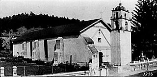
Mission San Buenaventura, formally known as the Mission Basilica of San Buenaventura, is a Catholic parish and basilica in the Archdiocese of Los Angeles. The parish church in the city of Ventura, California, United States, is a Spanish mission founded by the Order of Friars Minor. Founded on March 31, 1782, it was the ninth Spanish mission established in Alta California and the last to be established by the head of the Franciscan missions in California, Junípero Serra. Designated a California Historical Landmark, the mission is one of many locally designated landmarks in downtown Ventura.

<span class="mw-page-title-main">Ventura, California</span> City in California, United States

Ventura, officially named San Buenaventura, is a city in and the county seat of Ventura County, California, United States. The population was 110,763 at the 2020 census. Ventura is a popular tourist destination, owing to its historic landmarks, beaches, and resorts.

<span class="mw-page-title-main">Ventura County Courthouse</span> Historic building in Ventura, California used as City Hall

The Ventura County Courthouse, known since 1974 as Ventura City Hall, is a historic building in Ventura, California. It is located on a hill at the top of California Street, overlooking the city's downtown district with views of the Santa Barbara Channel and Channel Islands. It was the first building in the City of Ventura to be listed on the National Register of Historic Places and has also received historic designations at the state, county and city levels.

<span class="mw-page-title-main">Rancho Camulos</span> Historic ranch near Santa Paula, California

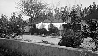
Rancho Camulos, now known as Rancho Camulos Museum, is a ranch located in the Santa Clara River Valley 2.2 miles (3.5 km) east of Piru, California and just north of the Santa Clara River, in Ventura County, California. It was the home of Ygnacio del Valle, a Californio alcalde of the Pueblo de Los Angeles in the 19th century and later elected member of the California State Assembly. The ranch was known as the Home of Ramona because it was widely believed to have been the setting of the popular 1884 novel Ramona by Helen Hunt Jackson. The novel helped to raise awareness about the Californio lifestyle and romanticized "the mission and rancho era of California history."

<span class="mw-page-title-main">Olivas Adobe</span> Historic house in California, United States

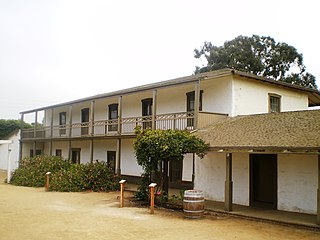
The Olivas Adobe in Ventura, California is an adobe structure built in 1837 by Raymundo Olivas on the north bank of the Santa Clara River about a mile from the estuary where it flows into the Santa Barbara Channel.

<span class="mw-page-title-main">Topatopa Mountains</span> Mountain range of the Transverse Ranges in California, United States

The Topatopa Mountains are a mountain range in Ventura County, California, north of Ojai, Santa Paula, and Fillmore. They are part of the Transverse Ranges of Southern California.

<span class="mw-page-title-main">San Buenaventura Mission Aqueduct</span> United States historic place

The San Buenaventura Mission Aqueduct was a seven-mile long, stone and mortar aqueduct built in the late 18th and/or early 19th century to transport water from the Ventura River to the Mission San Buenaventura in Ventura, California.

<span class="mw-page-title-main">Elizabeth Bard Memorial Hospital</span> United States historic place

Elizabeth Bard Memorial Hospital, now known as The Elizabeth Bard Memorial Building, is a historic building in downtown Ventura, California. Built in 1901, it is a Mission Revival structure featuring covered terraces and a covered porch with a three-story bell tower at the southeast corner. The building was listed as Ventura Historic Landmark No. 19 in 1976 and was added to the National Register of Historic Places in 1977.

<span class="mw-page-title-main">Rancho Las Virgenes</span> Historic land grant in Southern California, United States

Rancho Las Vírgenes was a 17,760-acre (71.9 km2) land grant in the Santa Monica Mountains and Simi Hills, in present day western Los Angeles County, California. The lands of the Rancho Las Vírgenes included present day Agoura Hills, Oak Park, and Westlake Village and part of the Santa Monica Mountains.

Rancho Sespe was a 8,881-acre (35.94 km2) Mexican land grant in present-day Ventura County, California given in 1833 by Governor José Figueroa to Carlos Antonio Carrillo. The grant encompassed the Santa Clara River Valley between Piru Creek on the east and Santa Paula Creek on the west, and was bounded to the north and south by the mountains, and included present day Fillmore.

<span class="mw-page-title-main">City of Ventura Historic Landmarks and Districts</span>

The City of Ventura Historic Landmarks and Districts consist of buildings, sites, and neighborhoods designated by the City of Ventura, California, as historic landmarks and districts.

<span class="mw-page-title-main">Statues of Junípero Serra (Ventura, California)</span> 1936 Federal Art Project in Ventura, California of Junípero Serra

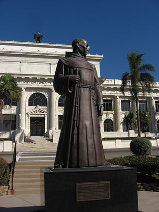
A statue in Ventura, California, representing Junípero Serra, the founder of Mission San Buenaventura, was commissioned by Ventura County through the Works Progress Administration as part of the Federal Art Project in 1935. This statue, made of concrete from a clay model by Uno John Palo Kangas, was placed in a prominent location in a public park across the street from the Ventura County Courthouse in 1936. After the Courthouse was repurposed as Ventura City Hall, the statue was designated as City of Ventura Historic Landmark No. 3 in 1974. As deterioration of the concrete statue became a concern, a wood replica was created by local carvers and used to make a bronze cast. The concrete statue was replaced by the bronze cast in 1989. The wood replica was set in the atrium of the city hall for public display.

<span class="mw-page-title-main">Serra Cross</span>

The Serra Cross, sometimes also known as the Cross on the Hill or the Grant Park Cross, is a Christian cross on a hill known as "La Loma de la Cruz" in Ventura, California. The site is in Serra Cross Park, a one-acre parcel within the larger Grant Park that overlooks downtown Ventura, the Santa Barbara Channel, and Anacapa and Santa Cruz Islands.

<span class="mw-page-title-main">Peirano Market</span> Historic site in Ventura, California

The Peirano Market, also known as Peirano's Grocery and Peirano Store, is a historic building in Ventura, California. Located across the street from the Mission San Buenaventura, the red brick structure was built in 1877 and has ornamental relief brickwork and a mansard, Spanish revival tile roof.

<span class="mw-page-title-main">Santa Gertrudis Asistencia</span>

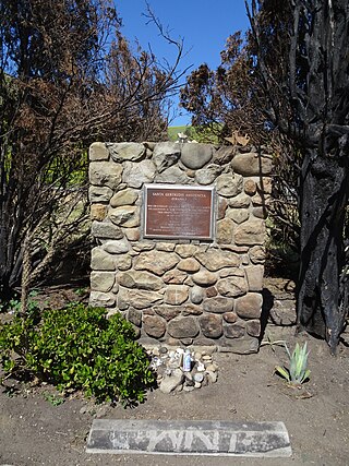
The Santa Gertrudis Asistencia, also known as the Santa Gertrudis Chapel, was an asistencia ("sub-mission") to the Mission San Buenaventura, part of the system of Spanish missions in Las Californias—Alta California. Built at an unknown date between 1792 and 1809, it was located approximately five miles from the main mission, inland and upstream along the Ventura River. The site was buried in 1968 by the construction of California State Route 33. Prior to the freeway's construction, archaeologists excavated and studied the site. A number of foundation stones were moved and used to create the Santa Gertrudis Asistencia Monument which was designated in 1970 as Ventura County Historic Landmark No. 11.

<span class="mw-page-title-main">E. P. Foster</span>

Eugene Preston Foster, commonly known as E. P. Foster, was a rancher, entrepreneur, banker, and philanthropist in Ventura County, California.

The Ortega-Vigare Adobe is second oldest adobe in the San Gabriel Valley, built in 1792. The Ortega-Vigare Adobe was designated a California Historic Landmark (No.632) on Nov. 2, 1949. The Ortega-Vigare Adobe is located is in what is now the City of San Gabriel, California in Los Angeles County at 616 S Ramona Street, San Gabriel, Cal.

<span class="mw-page-title-main">1812 Ventura earthquake</span> Magnitude 7.1 earthquake in Alta California on December 21, 1812

The 1812 Ventura earthquake occurred on the morning of December 21 at 11:00 Pacific Standard Time (PST). The 7.1–7.5 magnitude earthquake, with a Modified Mercalli intensity scale rating of X (Extreme), along with its resulting tsunami, caused considerable damage to present-day Santa Barbara and Ventura County, California, which was at the time a territory of the Spanish Empire. One person was killed as a result of the earthquake while another from the aftershock. The earthquake occurred just as the region was recovering from another event on the 8th of December the same year. Both events are thought to have been related.

<span class="mw-page-title-main">Battle of San Buenaventura</span> 1838 battle in California

The Battle of San Buenaventura was a battle fought on March 27 and March 28, 1838, between forces representing competing claims to the governorship of California, then a Mexican territory. The opposing forces consisted of supporters of Juan Bautista Alvarado based in Northern California and supporters of Carlos Antonio Carrillo from Southern California. The major action consisted of a cannon siege on the Carrillo loyalists who were encamped at the Mission San Buenaventura in Ventura, California. The Alvarado forces won the battle, as the Carrillo forces fled from the Mission under cover of darkness following the first day of the battle. Most of the Carillo forces were captured the following day at Saticoy, California. One person was killed in the battle, an Alvarado loyalist who was shot by a rifleman stationed in the Mission's bell tower.

References

  1. 1 2 3 4 5 6 "Is The Ortega Adobe Worth Saving?". The Ventura County Star-Free Press. August 24, 1969. p. B8 via The Museum of Ventura County (clippings file on "Adobes").
  2. 1 2 "Main Street adobes: Imagination provides a glimpse of Ventura's history". The Ventura County Star-Free Press. February 23, 1987. p. A12 via Museum of Ventura County (clippings file on "Adobes").
  3. 1 2 3 4 5 6 7 8 Article titled "Story of Old Adobe Building Here Is Told By Ortega Scion, reprinting a letter dated February 14, 1924, by E. C. Ortega. The clipping can be found in the "Adobes" clippings file at the Museum of Ventura County.
  4. "The Grand Spanish Ranch". Newhall Signal & Saugus Enterprise. August 28, 1981. p. 14 via Newspapers.com.
  5. Deed Books, Book B, pages=415, 418. Deed Books maintained by the Museum of Ventura County.
  6. An interpretive panel at the Ortega Adobe indicates that Lino Maria Anucahuit transferred the land to the Ortega family.
  7. "Ortega Adobe | Ventura, CA". www.cityofventura.ca.gov. Retrieved 2022-01-20.
  8. The Middle of Nowhere: The Carlos Carrillo Adobe, The Carrillo Family & Their Rancho Sespe. Ventura County Historical Society Quarterly, Volume 45, Number 2. 2001 via Museum of Ventura County.
  9. Wally Smith (August 2, 1970). "Historic Viewing Open To Public: Adobe's Tough Timber Exposed". The Ventura County Star-Free Press. pp. A1, A3 via Museum of Ventura County (clippings file on "Adobes").
  10. DeWitt Hogle (1982). "Adobes of the California Coast". Antepasados, Publication of Los Californianos, Volume 5. p. 6 via Museum of Ventura County.
  11. "About Ortega: Meet Mama Ortega, our founder ..." B&G Foods, Inc. Retrieved April 24, 2018.
  12. 1 2 3 "Ortega Adobe Historic Residence". City of Ventura. Retrieved April 8, 2018.
  13. "About Ortega". B&G Foods Inc. Retrieved April 8, 2018.
  14. 1 2 Arlene Goldberg (November 19, 1992). "Ventura adobe home to Ortega Chili Familia". Ventura Sun via The Museum of Ventura County (clippings file for "Adobes").
  15. "The Development of the Great Southwest". Los Angeles Times. November 19, 1899. p. 28 via Newspapers.com.
  16. "Ortega advertisement". Los Angeles Times. January 3, 1939. p. 73 via Newspapers.com.
  17. "Our Grand Old Names Are Vanishing!". The Los Angeles Times Sunday Magazine. February 9, 1936. p. 16.("The house of Ortega is widely advertised in this generation by E. C. Ortega, whose potent canned chili products tingle epicurean palates the world over.")
  18. 1 2 3 Susanne Hopkins (February 23, 1971). "Many Hands Help Restore Ortega Adobe" via The Museum of Ventura County (clippings file on "Adobes").
  19. 1 2 Richard Senate (July 24, 1985). "Forgotten Landmark: Ortega Adobe". Reporter Week. p. 1 via The Museum of Ventura County (clippings file on "Adobes").
  20. "Historic Ortega Adobe Opens Sunday". The Ventura County Star-Free Press. April 2, 1971 via Museum of Ventura County (clippings file on "Adobes").
  21. "200 See Opening Of Adobe". The Ventura County Star-Free Press. April 6, 1971 via The Museum of Ventura County (clippings file on "Adobes").
  22. "City of San Buenaventura Historic Landmarks & Districts". City of Ventura. May 3, 2016. Retrieved April 8, 2018.
  23. Interpretive panels located at the Ortega Adobe.