The City of Ventura Historic Landmarks and Districts consist of buildings, sites, and neighborhoods designated by the City of Ventura, California, as historic landmarks and districts.[1]
The first six sites designated as Ventura Historic Landmarks (VHL) were selected in February 1974. They are: the Olivas Adobe (VHL No. 1), the Ortega Adobe (VHL No. 2), the Father Serra statue (VHL No. 3), Ventura City Hall (VHL No. 4), the Grant Park cross site (VHL No. 5), and the Mission Plaza archeological site (VHL No. 6). In July 1974, the City also designated a second group of landmarks, including the Conklin residence (VHL No. 7), the Mission San Buenaventura (VHL No. 10), the Mission's Norfolk pine trees (VHL No. 8), and two large Moreton Bay fig trees located in city parks (VHL Nos. 11-12).[1]
As of April 10, 2018, the City had designated 111 sites as Ventura Historic Landmarks and five areas as Ventura Historic Districts.[1] The first historic district designated by the city was the Mission Historic District, extending from Poli Street at the northern border to Santa Clara Street at the southern border, and from Ventura Avenue on the west to Palm Street on the east. The Mission Historic District consists of the oldest section of the city's downtown area and includes more than ten historic landmarks, including the Mission, the Mission Plaza archeological site, the Mission's Norfolk pines, the Mission Plaza Moreton Bay fig tree, Peirano Store (VHL No. 32), the Carlo Hahn House (VHL No. 78), the Mission Lavanderia (VHL No. 85), and China Alley (VHL No. 91).
A map depicting the location of Ventura's designated historic landmarks and districts can be viewed by clicking "OpenStreetMap" or "Google Maps" in the template found to the right below.
A one-story adobe structure was built in 1837 and expanded in 1849 by Don Raimundo Olivas; listed on the National Register of Historic Places in 1979 and designated as California Historical Landmark No. 115; operated as a museum
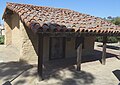
Adobe structure first built in 1857; the roof of the adobe used tiles from the Mission after the 1857 Fort Tejon earthquake; it became the first home of the Ortega chili company; open to public for self-guided tours
Concrete statue of Junípero Serra in front of Ventura City Hall commissioned by Ventura County through the Works Progress Administration as part of the Federal Art Project. The original statue, sculpted by Uno John Palo Kangas, was replaced in 1989 with a bronze cast. Bronze and wood replicas are not deemed historic. Location of original concrete is not disclosed.
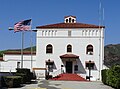
Neoclassical courthouse built in 1912, designed by Albert C. Martin Sr.; became Ventura City Hall in 1972; terra cotta exterior decorations, friars' heads, and copper-sheathed dome; listed on the National Register of Historic Places in 1971 (first site in City of Ventura to be so designated) and designated as California Historical Landmark No. 847 and Ventura County Historical Landmark No. 12
Site in Grant Park where a cross has been located for many year; some accounts indicate that the first cross was erected in 1782; the cross has been replaced several times, most recently in 1941[2]
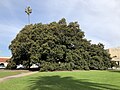
Norfolk Island pine trees (Araucaria heterophylla (synonym A. excelsa)) located adjacent to the San Buenaventura Mission, planted in the 1880s, lit during the Christmas season; designated in 2000 as California's Millennium Landmark Trees
Pepper tree formerly located on site of the Mound Guest House; had a trunk circumference of 23.5 feet, a height of 43 feet (13m), and a branch spread of 100 feet (30m); no longer exists
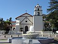
The ninth Spanish mission established in California, established in 1782 by Father Junípero Serra; also listed on the National Register of Historic Places in 1975 and designated as California Historical Landmark #310
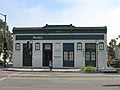
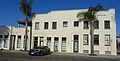
Built in 1920s for Ventura Guarantee and Loan, later became Bahn's Jewelry Store, now operated as Limon y Sal; has interior murals by Norman Kennedy; original white paint removed 1982
Archaeological site at the location of the first outpost and center of operations that was established while the Mission San Buenaventura was being constructed
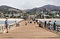
Wooden wharf first built in 1872, partially destroyed and rebuilt on multiple occasions; it was the longest wooden pier in California until a storm sheered off 420 feet in 1995
Began use in 1875 as a livery stable; used as a studio for the carving of a wooden replica of the Father Serra statue; has also been used as a coffeehouse music venue,[7] an arts center, and, later, as an improvisational comedy theater
Red brick structure built in 1877 with ornamental relief brickwork; the City's oldest surviving brick structure; operated as a general merchandise and, later, grocery store by the Peirano family for more than 100 years; archaeological remains of the Mission Lavanderia (VHL 85) discovered under the structure in 1991
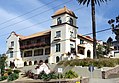
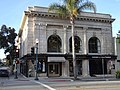
Spanish Renaissance style building designed by Albert C. Martin Sr., built in 1926, operated as the Bella Maggiore Inn for many years until closure due to COVID.
Commercial structure built in 1872, it housed two general merchandise stores and later the Great Eastern Department Store; at the southeast corner where Rabo Bank now operates; demolished in December 1979
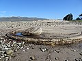
Seven-mile long aqueduct built starting in 1792 to supply water to the Mission San Buenaventura and local farms; the aqueduct began at the convergence point of San Antonio Creek and the Ventura River. The section of the aqueduct in the photograph is located at 234 Cañada Larga Road (south side), 1/4 block east of Highway 33, and has been listed on the National Register of Historic Places and designated as Ventura County Historical Landmark No. 28 and California Historic Landmark No. 114.
Known in the late 19th and early 20th centuries as Chautaqua Flats, the area was camping and amusement enterprises; later a freshwater refuge on the Pacific Flyway; the seven-acre site extends east from the junction of Vista Del Mar and Alessandro Drives for about three-tenths of a mile along Alessandro Drive to the west of the northern border fence for Highway 101.
Art Deco or Moderne style concrete office building with Aztec Revival flower elements designed by architect William W. Ache; later operated as a Mexican restaurant and then as the Fluid State bar
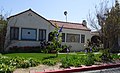
Home of a local activist, designated as a landmark; located in the Simpson Tract. Owen and her husband bought the house at the end of World War II and lived there for many years.[8]
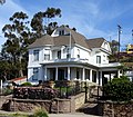
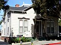
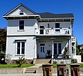
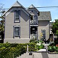
Victorian house built in 1905, then rebuilt and expanded in 1971; operated by a series of restaurants and bars ("Santa Clara House", "The Big Green House", "Andy's Barbecue Heaven," and most recently "The Tavern")[9]
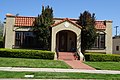
Spanish Colonial Revival apartment building built in 1929 to house oil workers with retail on first floor; a city library branch now operates on the ground floor
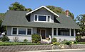
American Craftsman style house built in 1910 on a walnut farm in east Ventura; moved to its present location in 1990 where it became a French restaurant (since closed). Now home to Ten Tigers bar and Caje Coffee.
On January 5, 1847, during the Mexican–American War, John C. Frémont and elements of his California Battalion encamped in an orchard west of the Mission orchard's wall; there was a skirmish with locals in which a merchant, Don Jose Arnaz, was captured and forced to provide supplies.
117-acre ranch established in 1916 by Attilio Vanoni; associated with the development of the Saticoy area; the small parcel on Telephone Road is the site of the original Vanoni homestead
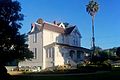
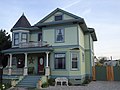
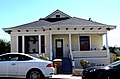
Colonial Revival house with a rock foundation and decorative wood posts, pilasters, carved dentils; built by Franklin and Julia Cook Hobart between 1892 and 1905
The district includes Plaza Park and the historic homes across Thompson Street from the park, including the Conklin Residence and the Mary Mitchell House; "the only intact and relatively unaltered block of houses remaining downtown"[11]
Four city blocks and 182 homes located west of Ventura Avenue, built from 1925 to 1930 provided affordable housing to workers during the city's oil boom; designated a historic district in 1990[12]
Old Mission Reservoir. Part of the water system for Mission San Buenaventura (the settling tank or receiving reservoir; the site can be found in Eastwood Park); designated as California Historical Landmark No. 114.
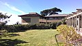
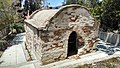
Santa Gertrudis Asistencia (Chapel) Monument. The structure was built in 1809 and ceased operation around 1840. The site was in the path of the Ojai freeway, and the remains were moved in 1968 with several foundation stones being used to create the monument. Located 0.3 miles north of the Avenue Water Treatment Facility (VHL 100) on the east side of the road, flanked by two cypress trees. Designated as Ventura County Historical Landmark No. 11 in December 1970.[14]
Five Trees. Five blue gum eucalyptus trees on the hilltop overlooking Ventura were designated in 1987 as Ventura County Historical Landmark No. 110. Joseph Sexton planted a row of 13 trees in 1898, but a 1903 fire destroyed all but five of the trees. Three of the remaining trees were cut down by vandals in 1940 but were replaced. In 1956, four of the trees were cut down, leaving only one. Replacement trees were planted in 1966 but only two remained for many years, known locally as "Two Trees".[14]Both are currently in very ill health, and a new one has been planted since.
1 2 3 "City of San Buenaventura Historic Landmarks & Districts". City of Ventura. May 3, 2016. Retrieved April 8, 2018.Note: The list available on-line has 108 landmarks. Landmarks 109, 110, and 111 were added in 2017 and are included in the updated list available at Ventura City Hall.
↑ "Home of Mabel Owen made historic landmark". unknown– via Research Library at the Ventura County Museum (clipping is in Binder 3 of the library's binders on the Ventura Historic Landmarks).
This page is based on this Wikipedia article Text is available under the CC BY-SA 4.0 license; additional terms may apply. Images, videos and audio are available under their respective licenses.