
The demographic profile of Cameroon is complex for a country of its population. Cameroon comprises an estimated 250 distinct ethnic groups, which may be formed into five large regional-cultural divisions:

The Northwest Region, or North-West Region is one of ten regions in Cameroon. Its regional capitol is Bamenda. The Northwest Region is part of the Southern Cameroons, found in the western highlands of Cameroon. It is bordered to the southwest by the Southwest Region, to the south by the West Region, to the east by the Adamawa Region, and to the north by the Federal Republic of Nigeria. Various Ambazonian nationalist and separatist factions regard the region as being distinct as a polity from Cameroon.
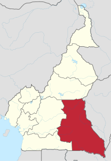
The East Region occupies the southeastern portion of the Republic of Cameroon. It is bordered to the east by the Central African Republic, to the south by Congo, to the north by the Adamawa Region, and to the west by the Centre and South Regions. With 109,002 km² of territory, it is the largest region in the nation as well as the most sparsely populated. Historically, the peoples of the East have been settled in Cameroonian territory for longer than any other of the country's many ethnic groups, the first inhabitants being the Baka pygmies.

Abbottabad District is a district of the Pakistani province of Khyber Pakhtunkhwa. It is part of Hazara Division and covers an area of 1,969 km2, with the city of Abbottabad being the principal town. Neighbouring districts are Mansehra to the north, Muzaffarabad to the east, Haripur to the west, and Rawalpindi to the south.
The Badwe'e are an ethnic group inhabiting the rain forest zone of southeastern Cameroon. They recognize themselves as the descendants of Edwe'e, the youngest son of Koo and the brother of Njeme and Nzime. The Badwe'e live south of Messaména in the East Province in a region south of the Bekol and both north and west of the Nzime. Their territory includes much of the northern and western border of the Dja Biosphere Reserve. They speak a dialect of Koozime, together with the Nzime.
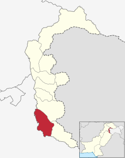
The Mirpur District is one of the 10 districts of Pakistan's dependent territory of Azad Kashmir.The Mirpur District is bounded on the north by the Kotli District, on the east by the Bhimber District, on the south by the Gujrat District of Pakistan's Punjab Province, on the south-west by the Jhelum District of Pakistan's Punjab Province, and on the west by Rawalpindi District of Pakistan's Punjab Province.The district is named after its main city, Mirpur. The Mirpur District has a population of 456,200 and covers an area of 1,010 km2 (390 sq mi). The district is mainly mountainous with some plains. Its hot, dry climate and other geographical conditions closely resemble those of the Gujrat District and the Jhelum District, the adjoining districts of Pakistan's Punjab Province.
The Mbum or Kebi-Benue languages are a group of the Mbum–Day branch of the Adamawa languages, spoken in southern Chad, northwestern Central African Republic, northern Cameroon and eastern Nigeria. Their best-known member is Mbum; other languages in the group include Tupuri and Kare.
The Mungo (Moungo) are an ethnic group of the Republic of Cameroon. Along with the other coastal peoples, they belong to the Sawa ethnic groups. The Mungo have historically been dominated by the Duala people, and the two groups share similar cultures, histories, and claims of origin.
Wum is a town and commune in Cameroon. It is the capital of Menchum division in the Northwest Province.
Mbengwi is the headquarters of Momo Department in the Northwest Region of Cameroon, located some 22 km from Bamenda.
Pongu (Pangu), or Rin, is a Kainji language spoken in Nigeria. There are about 20,000 speakers. Their main centre is in Pangu Gari town of Niger State, about 20 kilometres southeast of Tegina.

The Beboid languages are any of several groups of languages spoken principally in southwest Cameroon, although two languages are spoken over the border in Nigeria. They are probably not most closely related to each other. The Eastern Beboid languages may be most closely related to the Tivoid and Momo groups, though some of the geographical Western Beboid grouping may be closer to Ekoid and Bantu.
Dime or Dima is an Afro-Asiatic language spoken in the northern part of the Selamago district in the Southern Nations, Nationalities and Peoples Region of Ethiopia, around Mount Smith. Dime divides into at least two dialects, which include Us'a and Gerfa. It has six case suffixes in addition to an unmarked nominative. It is overwhelmingly suffixing, but uses prefixes for demonstratives and reduplication. Phonologically, it is noteworthy among the Omotic languages for having velar and uvular fricative phonemes. The basic word order is SOV (subject–object–verb), as in other Omotic languages, indeed as in all the languages of the core of the Ethiopian Language Area.
Chara is an Afro-Asiatic language of the North Omotic variety spoken in the Southern Nations, Nationalities, and People's Region of Ethiopia by 13,000 people.
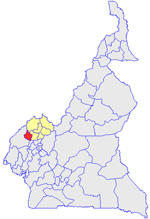
Momo is a department of Northwest Province in Cameroon. The department covers an area of 1792 km2 and as of 2005 had a total population of 138,693.It is the ethnic home of the Widikum People. The capital of the department lies at Mbengwi.
Jaba is a Local Government Area in southern Kaduna State, Nigeria. It covers an area of 531 km2. It is located close to the Jos Plateau region and Abuja in the central part of Nigeria in West Africa. The local government capital is in the town of Kwoi. The postal code of the area is 801.
The Widikum people are an ethnic group of Cameroon and are one of the largest ethnic groups of the North-West Region of Cameroon.
Misaje is a town and commune in Donga-Mantung department in the Northwest Region of Cameroon. The town lies at the top of the Ring Road, about 15 kilometers west of Nkambé, where the Ring Road meets the road north to Dumbu and the border with Nigeria.
Makolkol is a possible Papuan language formerly spoken on the Gazelle Peninsula of East New Britain Province on the island of New Britain, Papua New Guinea. Stebbins (2010) reports it is unattested. Palmer (2018) treats it as unclassified.
Mbule, also called Dumbule or Mbola, is an endangered Southern Bantoid language spoken by a few people in central Cameroon.
