
The English River is a river in Kenora District and Thunder Bay District in Northwestern Ontario, Canada. It flows through Lac Seul to join the Winnipeg River at Tetu Lake as a right tributary. The river is in the Hudson Bay drainage basin, is 615 kilometres (382 mi) long and has a drainage basin of 52,300 square kilometres (20,200 sq mi). Although there are several hydroelectric plants on this river, the English River upstream of Minnitaki Lake is notable as one of the few large river systems in northwestern Ontario with a natural flow and without any upstream source of pollution. It is the fourth longest river entirely in Ontario.

The Amable du Fond River is a river in Nipissing District, in Northern Ontario, Canada.
The Black Sturgeon River is a river in Thunder Bay District, Northwestern Ontario, Canada, located west of the Nipigon River, that flows to Lake Superior.
The Pukaskwa River is a river in Thunder Bay District and Algoma District in Northern Ontario, Canada. It is in the Great Lakes Basin and is a tributary of Lake Superior, which it enters at the south end of Pukaskwa National Park. It is a remote, pristine, free-flowing, medium-sized Shield river, with lots of whitewater, best travelled in spring.

The Gull River is a river in Thunder Bay District in Northwestern Ontario, Canada. The river is in the Great Lakes Basin and is a tributary of Lake Nipigon.

The Attawapiskat River is a river in Kenora District in northwestern Ontario, Canada, that flows east from Attawapiskat Lake to James Bay. It is the third largest river entirely in Ontario.
Attawapiskat Lake is a lake in Kenora District, Ontario, Canada. The primary inflows are the Otoskwin River, the Marten-Drinking River and the Pineimuta River. The two outflows are the Attawapiskat River and the North Channel, which itself flows into the Attawapiskat River.
The Ekwan River is a river in Kenora District in northwestern Ontario, Canada. It appears as Equam on Bellin map of 1744. Ekwan River is of Cree origin, meaning "the river far up the coast". It travels about 500 kilometres (311 mi) from its source at Zumar Lake on the Canadian Shield, through the Hudson Bay Lowlands, northeast and then east, to its mouth on James Bay.
Blue Jay Creek is a river on Manitoulin Island in Central Manitoulin and Tehkummah townships, Manitoulin District in northeastern Ontario, Canada, and a tributary of Lake Huron.

The Englehart River is a river in Timiskaming District in northeastern Ontario, Canada. It is in the Saint Lawrence River drainage basin and is a right tributary of the Blanche River.

The Groundhog River is a river in Cochrane District and Sudbury District in Northeastern Ontario, Canada. The river is in the James Bay drainage basin and is a left tributary of the Mattagami River.

The Mistik Creek is a stream in the Hudson Bay drainage basin in the Northern Region of Manitoba, Canada, approximately 20 kilometres (12 mi) northeast of Bakers Narrows.
The Kesagami River is a river in northern Cochrane District in Northeastern Ontario, Canada. It is part of the James Bay drainage basin, and is a left tributary of the Harricana River. The lower two-thirds of the river, from about Kesagami Lake and downstream for 112 kilometres (70 mi) to its mouth, are part of Kesagami Provincial Park.
The Makobe River is a river in northeastern Ontario, Canada. It is in the Saint Lawrence River drainage basin, and is a left tributary of the Montreal River.

The Larder River is a river in Timiskaming District, in Northeastern Ontario, Canada. It is in the Saint Lawrence River drainage basin, and flows from its source at Larder Lake in geographic McFadden Township to its mouth as a left tributary of the Blanche River in the municipal township of Evanturel.
White Gull Creek is a river in the Canadian province of Saskatchewan. The river's source is White Gull Lake, near the south-western boundary of Narrow Hills Provincial Park and near the southern slopes of the Cub Hills. The river travels through boreal forest and muskeg en route to its mouth at the Torch River. The Torch River is a tributary of the Saskatchewan River as it flows into one of North America's largest inland fresh water deltas, the Saskatchewan River Delta. There are no communities nor settlements along the river.
Sturgeon Bay Provincial Park is a provincial park on the western shore of Lake Winnipeg in Manitoba, Canada. The park is considered to be a Class Ib protected area under the IUCN protected area management categories. It is 144.9 km2 (55.9 sq mi) in size.
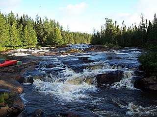
The Pipestone River is a river in northwestern Ontario, Canada. It is a major tributary of Winisk River via Wunnummin Lake. This pristine river flows through the rugged wilderness of Ontario's northern boreal forest, and drains into Wunnummin Lake.
The Pipestone River Provincial Park is a provincial park in northern Ontario, Canada, roughly 200 kilometres (120 mi) north of Sioux Lookout. It is a non-contiguous linear waterway park that consists of 3 segments, protecting 316-kilometre-long (196 mi) portions of the Pipestone, Morris, Williams, and Otoskwin Rivers. The segments are separated by an unprotected portion of the Pipestone River at Kingfisher 2A reserve, and between Kecheokagan Lake and the Nord Road. It was established on January 3, 1989, and provides backcountry whitewater canoeing and camping opportunities.

