Havering-atte-Bower is a village and outlying settlement of Greater London, England. It is located in the far north of the London Borough of Havering, on the border with Essex, and is 15 miles (24 km) northeast of Charing Cross. It was one of three former parishes whose area comprised the historic Royal Liberty of Havering.
Meenambakkam is a southern neighbourhood of Chennai in the Indian state of Tamil Nadu. It is home to Chennai International Airport, the Airports Authority of India regional office, and the DGQA Complex. It was under the reign of the Pallava kingdom. The name Meenambakkam signifies that it is a settlement near the coast. Pakkam means a settlement near to the coast. Meenambakkam was cherished with lakes, ponds and borderlines the Adyar river. This makes it a rich source of fishes. Hence the name Meenambakkam was coined.

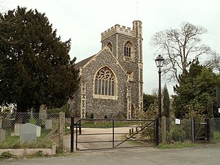
Benington is a village and civil parish in the East Hertfordshire district of Hertfordshire, England, about four miles east of Stevenage and 35 miles north of London.
Tal is a town and a nagar parishad in Ratlam District of the Indian state of Madhya Pradesh. Raja Tariya Bhil established Tal in 1243 AD.

Antara Gange is a mountain situated in the Shathashrunga mountain range in the southeastern portion of the Indian state of Karnataka, Kolar district. Antara Gange literally means "Ganges from deep" in Kannada. It is about two miles from the town of Kolar and seventy kilometers from Bangalore. Antara Gange is famous for Sri Kashi Vishweshwara temple, also known as Kashi of South. The temple is dedicated to Lord Shiva. In the temple is a pond which gets a continuous flow of underground water from the mouth of a Basava. It is believed that drinking water from the pond cleanse one from many diseases.

Mihintale is a mountain peak near Anuradhapura in Sri Lanka. It is believed by Sri Lankans to be the site of a meeting between the Buddhist monk Mahinda and King Devanampiyatissa which inaugurated the presence of Buddhism in Sri Lanka. It is now a pilgrimage site, and the site of several religious monuments and abandoned structures.
Veliyanad is a small village in the Ernakulam District of the state of Kerala in southern India. It belongs to the Edakkattuvayal panjayat and Kanayannoor Taluk. The village is around 30 km from the city of Kochi. nearby city is Piravom The nearest airport is Cochin International Airport. Piravom Road, Ernakulam Town and Ernakulam Junction Railway Stations are the closest major railway stations.

Plonéour-Lanvern is a commune in the Finistère department of Brittany in north-western France.

The Dead River is a 3.5-mile-long (5.6 km) river located entirely within the city limits of Berlin, New Hampshire, in the United States. It is a tributary of the Androscoggin River, which flows south from Berlin before turning east at Gorham and into Maine, eventually joining the Kennebec River at Merrymeeting Bay. The Abenaki people called the Dead River Plumpetoosuc, which means "shallow, narrow river".

Peruvayal is the largest village in Kozhikode district in the Indian state of Kerala. This village is surrounded by Panchayaths of Mavoor, Kunnamangalam, Olavanna and Kozhikode corporation. The Chaliyar river forms one of the borders of Peruvayal and is 15 km away from Kozhikode.
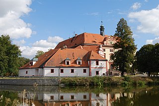
Lnáře is a municipality and village in Strakonice District in the South Bohemian Region of the Czech Republic. It has about 700 inhabitants.
Perumalpattu is a suburb of Chennai Indian state of Tamil Nadu. It is situated between Chennai and Arakkonam near the Chennai–Arakkonam railway line. It is a town in the suburb of Chennai.

Urman is a village of 622 people in Ternopil Raion (county) of Ternopil Oblast (province) of western Ukraine. It lies in the historic region of Halychyna and during 1772-1918 was part of Austrian empire, consequently of Poland in 1920-1939 and of Soviet Union in 1939-1991. Urman belongs to Berezhany urban hromada, one of the hromadas of Ukraine.
Smørumnedre is a town and suburban area situated in Egedal Municipality in the northwestern outskirts of Copenhagen, Denmark and forms part of Copenhagen's urban area. The original village has merged with the neighbouring villages of Måløv in Ballerup Municipality and Jonstrup in Furesø Municipality to form an urban agglomeration with a population of 20,657. The small and relatively undisturbed village of Smørumovre is located about 500 metres to the west of Smørumnedre while Lille Smørum("Little Smørum") refers to a group of scattered farms to the south. The three localities are collectively referred to as Smørum.
Sureban is a village in Belgaum district of Northern Karnataka, India. Usually the place is referred to as Sureban-Manihal. They are separate villages, but in spirit are the same.
Avalurpet is a village town panchayat in melmalayanur taluk of Viluppuram district. It has a population of 3000 and acts as a junction for Thiruvannamalai and Melmalayanur temple and kelpennathur and chetpat.
Jamugurihat is a town and a town area committee in Sonitpur district, in the Indian state of Assam. This is a newly planned city area by the Urban Development Authority of Assam. The town is located north of the Brahmaputra River. It is the location of the 200-year-old Baresahariya Bhaona festival.
Dhab Kalan is a small village of Har Char Dhab Union council, Chakwal District in the Punjab Province of Pakistan.

Apsarkonda is an emerging tourist village near Honnavar, in the district of Uttara Kannada, Karnataka, India. It is situated 8 km from the Honnavar bus stand.
Dosanjh Kalan is a village in Phillaur tehsil of Jalandhar District of Punjab State, India. Kalan is Persian language word which means Big and Khurd is Persian word which means small when two villages have same name then it is distinguished with Kalan means Big and Khurd means Small used with Village Name.


