Related Research Articles

Ottawa is the capital city of Canada. It stands on the south bank of the Ottawa River in the eastern portion of southern Ontario. Ottawa borders Gatineau, Quebec, and forms the core of the Ottawa–Gatineau census metropolitan area (CMA) and the National Capital Region (NCR). As of 2016, Ottawa had a city population of 934,243 and a metropolitan population of 1,323,783 making it the fourth-largest city and the fifth-largest CMA in Canada. In June 2019, the City of Ottawa estimated it had surpassed a population of one million.

Holland is a city in the western region of the Lower Peninsula of the U.S. state of Michigan. It is situated near the eastern shore of Lake Michigan on Lake Macatawa, which is fed by the Macatawa River.

Riverview is a neighbourhood in Ottawa, Ontario, Canada. It is southeast of the downtown adjacent to the Rideau River, its location on which is its namesake. The 2016 Census population of Riverview is 12,218.
Bytown is the former name of Ottawa, Ontario, Canada. It was founded on September 26, 1826, incorporated as a town on January 1, 1850, and superseded by the incorporation of the City of Ottawa on January 1, 1855. The founding was marked by a sod turning, and a letter from Governor General Dalhousie which authorized Lieutenant Colonel John By to divide up the town into lots. Bytown came about as a result of the construction of the Rideau Canal and grew largely due to the Ottawa River timber trade. Bytown's first mayor was John Scott, elected in 1847.

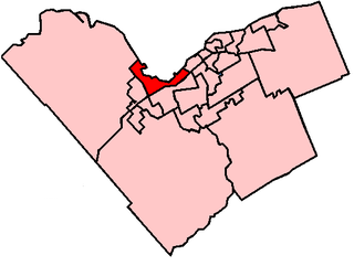
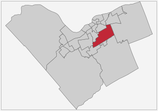
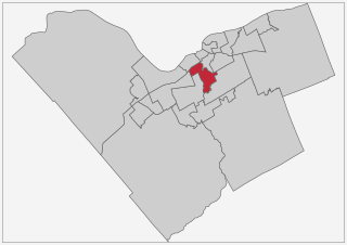
Ottawa—Vanier is a federal electoral district in Ontario, Canada, that has been represented in the House of Commons of Canada since 1935. Previous to that date, it was part of the Ottawa electoral district that returned two members.
The Regional Municipality of Hamilton–Wentworth was a regional municipality that was proclaimed on January 1, 1974 in the province of Ontario, Canada. In 2001, the towns and cities in the region of Hamilton–Wentworth was merged to form the current city of Hamilton with a 2016 total population of 721,053.

The ByWard Market, is a retail and entertainment district in downtown Ottawa, Ontario, Canada. It is located east of the government and business district. The Market district includes the market buildings and open-air market along George, York, ByWard, and William street.

Downtown Ottawa is the central area of Ottawa, Ontario, Canada. Like other downtowns it is the commercial and economic centre of the city. It is sometimes referred to as the Central Business District and contains Ottawa's financial district. It is bordered by the Ottawa River to the north, the Rideau Canal to the east, Gloucester Street to the south and Bronson Avenue to the west. This area and the residential neighbourhood to the south are also known locally as 'Centretown'. The total population of the area is 4,876.

Britannia is a group of neighbourhoods in Bay Ward in the west end of Ottawa, Ontario, Canada. It is located on the Ottawa River across from Aylmer, Quebec, adjacent to its namesake, Britannia Bay, north of Richmond Road, west of the Sir John A. Macdonald Parkway and east of Boyce Avenue. The total population of this area was 6,692 as of the 2016 census. The area constituted a municipal ward from 1973 to 1994.
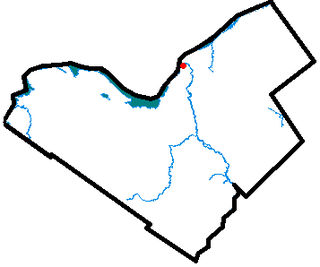
Lower Town (also spelled "Lowertown" is a neighbourhood in Rideau-Vanier Ward in central Ottawa, Ontario, Canada, to the east of downtown. It is the oldest part of the city. It is bounded by Rideau Street to the south, the Ottawa River to the west and north and the Rideau River to the east. It includes the commercial Byward Market area in the south-western part, and is predominantly residential in the north and east.
Ottawa—Vanier is a provincial electoral district in Ottawa, Ontario, Canada, that has been represented in the Legislative Assembly of Ontario since 1908. It is located in the east end of Ottawa.

Hunt Club is a community in River Ward, in the south end of Ottawa, Ontario, Canada. The area is named after the prestigious Ottawa Hunt and Golf Club, which has been part of the area since 1876. Hunt Club Road and many local businesses were also named after the golf course.
Bay Ward or Ward 7 is a municipal ward in Ottawa, Ontario, Canada. It covers much of the western portion of the old city of Ottawa as well as some portions of what was once Nepean. The ward runs from Sherbourne and Maitland in the east to March Road in the west. The southern border is the Queensway while the northern border is the Ottawa River. The ward makes up the northern portion of the federal and provincial riding of Ottawa West-Nepean.
Gloucester-Southgate Ward is a city ward located in Ottawa, Ontario. Located in the city's south end, the ward includes Gloucester Glen east of the Rideau River, most of the Ottawa International Airport, CFSU Uplands, Blossom Park, Greenboro, portions of Heron Gate south of Walkley Road, the Ottawa South/Hawthorne Industrial Park and rural areas west of Anderson Road and north of Leitrim. Previously, the ward included the community of Riverside South located south of the airport but in a ward reorganization, the growing community was included in the new ward of Gloucester-South Nepean.
River Ward or Ward 16 is a municipal ward located in Ottawa, Ontario. It is located in the south central portion of the city, and includes the communities of Carlington, Central Park, Carleton Heights, Mooney's Bay, Riverside Park and Hunt Club/Uplands. The ward spans both sides of the Rideau River between Carling Avenue and Hunt Club Road.

Capital Ward or Ward 17 is a city ward located in the centre of Ottawa, Ontario. Situated just south of downtown Ottawa, the ward includes the communities of Old Ottawa East, Old Ottawa South, the Glebe, Heron Park, Carleton University, and Riverside

Rideau-Goulbourn Ward is a city ward located in Ottawa, Ontario. Situated in the rural south end of the city, the ward includes rural areas west of the Rideau River and the communities of Manotick, Richmond, North Gower, Munster, Kars, Fallowfield, Ashton and Burritts Rapids as well as Goulbourn Township south and west of Stittsville.

Lower Hutt is a city in the Wellington Region of the North Island of New Zealand. Administered by the Hutt City Council, it is one of the four cities that constitute the Wellington metropolitan area.
By Ward was one of the five original wards represented on Ottawa City Council, created in 1855 out of parts of East Ward and Centre Ward which existed in Bytown. Originally it represented the area between Rideau Street and St. Patrick Street. Today this area is part of the By Ward Market, which is named for the historic ward.
References
- ↑ Taylor, John H. (1986). Ottawa: An Illustrated History. ISBN 9780888629807.