Otter Rapids Generating Station

Last updated
Otter Rapids Generating Station

Otter Rapids Dam.JPG

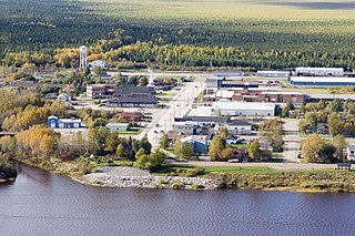
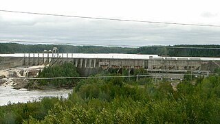
Otter Rapids Dam and Generating Station as seen from the Ontario Northland Railway
Canada Ontario relief location map.jpg
Red pog.svg
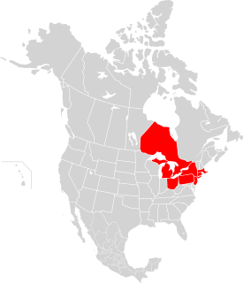
Location of Otter Rapids Generating Station in Ontario
Country Canada
Location Cochrane District, Ontario
Coordinates 50°11′01″N81°38′10″W / 50.18361°N 81.63611°W / 50.18361; -81.63611 Coordinates: 50°11′01″N81°38′10″W / 50.18361°N 81.63611°W / 50.18361; -81.63611
Status Operational
Opening date September 26, 1961 (1961-09-26)
Owner(s) Ontario Power Generation
Dam and spillways
Type of dam Embankment dam
Spillways 1
Spillway type Controlled chute
Power Station
Turbines 4 x 46 MVA, 60 Hz, 138.4 RPM [1]
Installed capacity 182 MW
Website
www.opg.com/generating-power/hydro/northeast-ontario/Pages/otter-rapids-station.aspx

Otter Rapids Generating Station is a dam and hydroelectric power plant located in Pitt Township [2] in the Unorganized North Part of Cochrane District in Northeastern Ontario, Canada. [3] Owned by Ontario Power Generation, this 4-unit, 182 MW station is part of the Northeast Plant Group. [4] The Ontario Northland Railway runs past this facility. [5]

Dam A barrier that stops or restricts the flow of surface or underground streams

A dam is a barrier that stops or restricts the flow of water or underground streams. Reservoirs created by dams not only suppress floods but also provide water for activities such as irrigation, human consumption, industrial use, aquaculture, and navigability. Hydropower is often used in conjunction with dams to generate electricity. A dam can also be used to collect water or for storage of water which can be evenly distributed between locations. Dams generally serve the primary purpose of retaining water, while other structures such as floodgates or levees are used to manage or prevent water flow into specific land regions. The earliest known dam is the Jawa Dam in Jordan, dating to 3,000 BC.

Hydroelectricity electricity generated by hydropower

Hydroelectricity is electricity produced from hydropower. In 2015, hydropower generated 16.6% of the world's total electricity and 70% of all renewable electricity, and was expected to increase about 3.1% each year for the next 25 years.

Unorganized North Cochrane District Unorganized area in Ontario, Canada

Unorganized North Cochrane District is an unorganized area in the District of Cochrane in northeastern Ontario, Canada. It comprises all parts of the district north of Timmins and Iroquois Falls which are not part of an incorporated municipality.

Contents

Preliminary surveys of the site were conducted in 1945. In 1951 additional site information was gathered with studies and estimates refined. Approval under the Navigable Waters Protection Act was received in October 1958 and the first generating unit came online on September 26, 1961. [4]

The Otter Rapids Generating Station was the last of four generating stations completed on the Abitibi River in the James Bay watershed.

Abitibi River tributary of Moose river, flowing in North-East of Ontario, in Canada.

The Abitibi River is a river in northeastern Ontario, Canada, which flows northwest from Lake Abitibi to join the Moose River which empties into James Bay. This river is 540 kilometres (340 mi) long, and descends 265 metres (869 ft).

James Bay A bay on the southern end of the Hudson Bay, Canada

James Bay is a large body of water on the southern end of Hudson Bay in Canada. Both bodies of water extend from the Arctic Ocean, of which James Bay is the southernmost part. It borders the provinces of Quebec and Ontario. Islands within the bay are part of the Nunavut territory.

Drainage basin Area of land where precipitation collects and drains off into a common outlet

A drainage basin is any area of land where precipitation collects and drains off into a common outlet, such as into a river, bay, or other body of water. The drainage basin includes all the surface water from rain runoff, snowmelt, and nearby streams that run downslope towards the shared outlet, as well as the groundwater underneath the earth's surface. Drainage basins connect into other drainage basins at lower elevations in a hierarchical pattern, with smaller sub-drainage basins, which in turn drain into another common outlet.

A community of employees and their families inhabited the adjacent colony called Otter Rapids. This community of over 1,000 people was well equipped with a bank, post office, snack bar, grocery store, billiard hall, bowling alley, curling rink, hockey rink, fire hall, 10-bed hospital and auditorium. [4]

Otter Rapids, Ontario Community in Ontario, Canada

Otter Rapids, also known as White Otter Rapids is an unincorporated place and dispersed rural community in geographic Pitt Township in the Unorganized North Part of Cochrane District in Northeastern Ontario, Canada. It is located 148.9 km south of Moosonee and 120 km north of Smooth Rock Falls.

See also

Related Research Articles

Moosonee Town in Ontario, Canada

Moosonee is a town in northern Ontario, Canada, on the Moose River approximately 19 kilometres (12 mi) south of James Bay. It is considered to be "the Gateway to the Arctic" and has Ontario's only saltwater port. Nearby on Moose Factory Island is the community of Moose Factory to which it is connected by water taxi in the summer and ice road in the winter.

Pickering Nuclear Generating Station

Pickering Nuclear Generating Station is a Canadian nuclear power station located on the north shore of Lake Ontario in Pickering, Ontario. It is one of the oldest nuclear power stations in the world and Canada's third-largest, producing about 15% of Ontario's power and employing 3,000 workers.

Bruce Nuclear Generating Station Canadian power station

Bruce Nuclear Generating Station is a nuclear power station located on the eastern shore of Lake Huron in Ontario. It occupies 932 ha of land. The facility derives its name from Bruce County in which it is located, in the former Bruce Township. It is the largest nuclear generating station in the world by total reactor count, the number of currently operational reactors, and total output. The station is the largest employer in Bruce County, with over 4000 workers.

Darlington Nuclear Generating Station

Darlington Nuclear Generating Station is a Canadian nuclear power station located on the north shore of Lake Ontario in Clarington, Ontario. It is a large nuclear facility comprising four CANDU nuclear reactors with a total output of 3,512 MWe when all units are online. It is Canada's second-largest NPS and provides about 20 percent of Ontario's electricity needs, enough to serve a city of two million people.

OPG 7 commemorative turbine

The OPG 7 Gomberg Turbine is a Vestas model V80-1.8MW wind turbine in Pickering, Ontario. At the time of its construction, it was one of the largest wind turbines in North America, a 117-metre high wind machine commissioned in 2001 and designed to produce enough power to satisfy about 600 average households. This electricity is also emission-free.

Hearn Generating Station decommissioned power station in Toronto, Canada

The Richard L. Hearn Generating Station is a decommissioned electrical generating station in Toronto, Ontario, Canada. The plant was originally fired by coal, but later converted to burn natural gas. The plant has been described as "Pharaonic in scale", and encompasses 650 thousand cubic metres of space—large enough to fit 12 Parthenons inside.

Turkey Point Nuclear Generating Station Nuclear power plant in the State of Florida

Turkey Point Nuclear Generating Station is a twin reactor nuclear power station located on a 3,300-acre (1,300 ha) site two miles east of Homestead, Florida, United States, next to Biscayne National Park located about 25 miles (40 km) south of Miami, Florida near the southernmost edge of Miami-Dade County. The facility is owned by Florida Power & Light.

Nanticoke Generating Station

The Nanticoke Generating Station is a 44 MW solar power station which started operation in April 2019. Previously from 1972 to 2013, it was the largest coal-fired power plant in North America. At full capacity, it could provide 3,964 MW of power into the southern Ontario power grid from its base in Nanticoke, Ontario, Canada. It is owned by Ontario Power Generation. It was decommissioned in 2013 as part of the Government of Ontario's commitment to eliminate coal power. Prior to the commencement of decommissioning, Nanticoke was one of Canada's top ten single sources of greenhouse gases.

Northeast blackout of 2003

The Northeast blackout of 2003 was a widespread power outage throughout parts of the Northeastern and Midwestern United States and the Canadian province of Ontario on August 14, 2003, beginning just after 4:10 p.m. EDT.

Ear Falls Township in Ontario, Canada

Ear Falls is a community and township located in Northwestern Ontario, Canada, on the right bank of the English River near the outlet of Lac Seul. It is located along Highway 105, 100 kilometres (62 mi) north of Highway 17 and Vermilion Bay, about halfway between Highway 17 and Red Lake, or about 480 kilometres (300 mi) northwest of Thunder Bay.

Great Lakes Basin drainage basin of the Great Lakes in North America

The Great Lakes Basin consists of the Great Lakes and the surrounding lands of the states of Illinois, Indiana, Michigan, Minnesota, New York, Ohio, Pennsylvania, and Wisconsin in the United States, and the province of Ontario in Canada, whose direct surface runoff and watersheds form a large drainage basin that feeds into the lakes. It is generally considered to also include a small area around and beyond Wolfe Island, Ontario, at the east end of Lake Ontario, which does not directly drain into the Great lakes, but into the Saint Lawrence River.

Kakabeka Generating Station

Kakabeka Generating Station is a hydroelectric facility operated by Ontario Power Generation on the bank of the Kaministiquia River, 2 km (1.2 mi) downstream from Kakabeka Falls in the community of Kakabeka Falls, Ontario, 30 km (19 mi) west of Thunder Bay. The plant provides energy to the city of Thunder Bay and area. The station is one of ten hydroelectric stations in Ontario Power Generation's Northwest Plant Group, and is remotely operated from Thunder Bay.

Lambton Generating Station

The Lambton Generating Station was a coal-fuelled power plant located on the St. Clair River near Corunna, Ontario, delivering up to 950 MW of power to the grid. It is owned by Ontario Power Generation.

Abitibi Canyon Generating Station

Abitibi Canyon Generating Station is a hydroelectric power plant owned by Ontario Power Generation on the Abitibi River. The station is located 80 km north of Smooth Rock Falls, within Pitt Township in Northern Unorganized Cochrane District, in Ontario, Canada. This facility is the fifth downstream hydroelectric plant of six on the Abitibi River. Designed by George F. Hardy Company, the construction of this 349 MW facility began in 1930 and became fully operational in 1936. Hydro One has a 500 kV transmission line along with a 230 kV line that runs south to Sudbury and continues all the way to Toronto to interconnect with the rest of the 500 kV network in Ontario.

Lennox Generating Station

Lennox Generating Station is a natural gas-fired station in Lennox and Addington County, Ontario, Canada. Owned and operated by Ontario Power Generation, it is situated on Highway 33 on the north shore of Lake Ontario, 2 miles (3.2 km) west of Bath, Ontario.

Kapuskasing River river in Northeastern Ontario, Canada

The Kapuskasing River is a river in the James Bay drainage basin in Cochrane District and Algoma District in northeastern Ontario, Canada. The river is a left tributary of the Mattagami River.

References

  1. Bomben, Stefano G; Pratt, Brian I (2001-05-02). "Pre-Outage Installation Of The Air Gap Monitoring System Reduces Outage Time And Saves Money" (PDF). User Conference on Machine Condition Monitoring – Orlando, Florida, USA – May 1–2, 2001. Archived from the original (PDF) on 2006-05-26. Retrieved 2011-10-14.
  2. "Pitt" (PDF). Geology Ontario - Historic Claim Maps. Ontario Ministry of Northern Development, Mines and Forestry . Retrieved 2011-10-14.
  3. "Otter Rapids". Geographical Names Data Base. Natural Resources Canada . Retrieved 2011-10-14.
  4. 1 2 3 "Otter Rapids Generating Station". www.opg.com. Toronto. Archived from the original on 13 November 2014. Retrieved 11 February 2015.
  5. Martin, Douglas (1984-06-03). "Polar Bear Express". The New York Times . Retrieved 2010-07-30.