
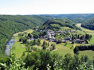
Ouren is a village in Belgium with a population of 129 inhabitants. Ouren is a part of the municipality of Burg-Reuland and thus belongs to the German-speaking Community of Belgium.
Ouren is a village in Belgium with a population of 129 inhabitants. Ouren is a part of the municipality of Burg-Reuland and thus belongs to the German-speaking Community of Belgium.
Ouren is located at the border triangle of Belgium-Germany-Luxembourg. All of the borders are tangent in the middle of the river Our.
Ouren Castle was founded approximately during the 11th or 12th century. For the first time it was mentioned in 1095 in connection with one of the lords of Ouren, Rycardis de Hunrin. It is assumed that at this point, Ouren Castle has already existed. In 1365 the Castle was merged into the ownership of the family of Malberg by marriage of William von Malberg with Elizabeth von Ouren. Shortly after, Castle Ouren was pledged to the archbishop of Treves. During the events of a feud between the archbishop Werner von Falkenstein and Eberhard von der Marck-Arenberg the fortification was besieged and taken by soldiers of the archbishop under leadership of Peter von Kronenburg.
After the end of the War of the Spanish Succession, Ouren became a part of the Austrian Netherlands between 1714 until 1795. In 1795 Castle Ouren was destroyed by troops of the French Revolution. During the Peasants’ War rioters barricaded themselves in the ruins of the castle. However, they had to abandon themselves to the French after a short combat.
In 1815, during the Congress of Vienna, Ouren became a part of the Prussian kingdom together with Eupen and Malmedy. In 1844 and 1845 the unoccupied castle was auctioned and left opened to demolition. Nowadays, only a few remains of the wall are present. [1] As a result of the First World War and according to the Treaty of Versailles Ouren was added to Belgium.

By leaving the centre of Ouren in direction of the town Heinerscheid in Luxembourg, the junction of Ribbach and Our is reached after a short time. At this junction the Europe Monument is located which was consecrated on 22 October 1977. The Monument was built in order of the initiative of Georg Wagner, the president of the confederation of the Eifel and Ardennes, assemblyman and president of the Luxembourg chamber. The Europe Monument is surrounded by a green space of five monumental boulders, information panels and flag poles. On four stones the names of the "Protagonists of a united Europe" (Konrad Adenauer, Joseph Bech, Paul-Henri Spaak and Robert Schuman) are engraved. The fifth stone commemorates the Treaty of Rome and the signees of the six states being involved. In the near of the Europe Monument close to the border triangle is a pedestrian bridge connecting Germany and Belgium via the River Our which is named after Georg Wagner.

The Church of St Peter and Paul was founded approximately during the 12th century. The tower and the nave are dating back to that period. In 1741 the ruinous choir was renovated, in 1921 a vestry was added. The church as well as the in 1896 founded Way of the Cross are listed.
The ′Rittersprung′ is a rock on the Northern entrance to the village Ouren-Peterskirchen. According to the legend a knight fell in the river Our with his mistress in order to escape his persecutors.
The legend tells of a robber baron who fell in love with the wife of the Lord of Ouren. Thus, he made a ploy to abduct the noble lady. After a nightly meeting on the foot of the castle he escaped with his mistress. Previously, he had shodden his horse but with the horse shoes on back to front. On this way, he wanted to delude the persecutors. However, the new horseshoes made such noise on the rocky surface that the couple was heard by its persecutors. The couple was confronted by its persecutors on a cliff that cut short steeply to the River Our and hence were trapped. In order to escape from captivity, the robber baron actuated his horse that jumped exceedingly from the cliff. The lovers fell into the river – nevertheless they survived – only the horse broke its legs. In return for the wondrous rescue the knight swore to found a chapel. However, as he did not fulfil his solemn promise he was hit by lightning. [2]

The castle ruins is situated on an off-set within the centre of the village on the left side of the river Our. Ouren Castle was the ancestral seat of the free nobles of Ouren. Dating back to the 11th century, the site was originally a segmented, fortificated castle fortress with a palas, a bergfried, a chapel as well as an outer bailey.
Between 1535 and 1615, periods of modification are marking the change to the residence of the nobility. [3] A re-drawing of the lost water-colour by Joseph-Ernest Buschmann (1814-1853) from the mid 19th century depicts the site as – a probably romanticized – Baroque castle. [4] In 1794 the castle was destroyed by French revolutionary troops and nearly fully demolished after 1845.
Today the castle ruin is considered being an archaeological site. Only single remains of the foundation and parts of the former enclosing walls are visible on the surface. Since 2012 the Archaeological Department of the German-speaking community of Belgium has been conducting excavations on the castle hill.
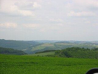
The Ardennes, also known as the Ardennes Forest or Forest of Ardennes, is a region of extensive forests, rough terrain, rolling hills and ridges. Geologically, the range is a western extension of the Eifel, and both were raised during the Givetian age of the Devonian, as were several other named ranges of the same greater range.

Liège is the easternmost province Belgium. It lies in the country's Wallonia region.

Burg-Reuland is a municipality located in the Belgian province of Liège. The name of the municipality refers to the castle "Burg-Reuland", which is located in the center of the community. On January 1, 2006, Burg-Reuland had a total population of 3,903. The total area is 108.96 km² which gives a population density of 36 inhabitants per km². Burg-Reuland is one of the municipalities of the German-speaking Community of Belgium.

Malmedy is a Walloon city and municipality in Liège Province, Belgium. On January 1, 2006, Malmedy had a total population of 11,829. The total area is 99.96 km² which gives a population density of 118 inhabitants per km².
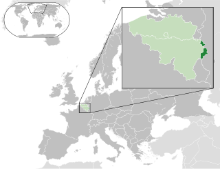
The German-speaking Community of Belgium or Eastern Belgium is one of the three federal communities of Belgium. Covering an area of 854 km2 (330 sq mi) within the Liège Province in Wallonia, it includes nine of the eleven municipalities of Eupen-Malmedy. Traditionally speakers of Low Dietsch, Ripuarian, and Moselle Franconian varieties, the local population numbers 77,949 – about 7.0% of Liège Province and about 0.7% of the national total.

The High Fens, which were declared a nature reserve in 1957, are an upland area, a plateau region in Liège Province, in the east of Belgium and adjoining parts of Germany, between the Ardennes and the Eifel highlands. The High Fens are the largest nature reserve or park in Belgium, with an area of 4,501.2 ha ; it lies within the German-Belgian natural park Hohes Venn-Eifel, in the Ardennes. Its highest point, at 694 metres (2,277 ft) above sea level, is the Signal de Botrange near Eupen, and also the highest point in Belgium. A tower 6 metres (20 ft) high was built here that reaches 700 metres (2,297 ft) above sea level. The reserve is a rich ecological endowment of Belgium covered with alpine sphagnum raised bogs both on the plateau and in the valley basin; the bogs, which are over 10,000 years old, with their unique subalpine flora, fauna and microclimate, are key to the conservation work of the park.

The Our is a river in Belgium, Luxembourg and Germany. It is a left-hand tributary of the river Sauer/Sûre. Its total length is 78 kilometres (48 mi).

Ourthe was a department of the French First Republic and French First Empire in present-day Belgium and Germany. It was named after the river Ourthe (Oûte). Its territory corresponded more or less with that of the present-day Belgian province of Liège and a small adjacent region in North Rhine-Westphalia in Germany. It was created on 1 October 1795, when the Austrian Netherlands, the Prince-Bishopric of Liège and the left bank of the Rhine were officially annexed by the French Republic. Before this annexation, the territory included in the department had lain partly in the Bishopric of Liège, the Abbacy of Stavelot-Malmedy, the Duchies of Limburg and Luxembourg, and the County of Namur.

The Duchy of Limburg or Limbourg was an imperial estate of the Holy Roman Empire. Much of the area of the duchy is today located within Liège Province of Belgium, with a small portion in the municipality of Voeren, an exclave of the neighbouring Limburg Province. Its chief town was Limbourg-sur-Vesdre, in today's Liège Province.
The Islek (Aquilania) is a part of the German Eifel region (Rhineland-Palatinate), in the Bitburg-Prüm district next to the Luxembourg and Belgian border.

Eupen-Malmedy or Eupen-Malmédy is a small, predominantly German-speaking region in eastern Belgium. It consists of three administrative cantons around the small cities of Eupen, Malmedy, and Sankt Vith which encompass some 730 square kilometres (280 sq mi). In the area itself, the region is referred to as East Belgium. Elsewhere in Belgium, the region is commonly referred to as the East Cantons.

Faymonville is a village in the Walloon municipality of Waimes, province of Liège, Belgium. Its inhabitants are nicknamed the "Turks" by the neighbouring towns and villages. It is believed that the inhabitants refused to join the crusades against the Ottoman Empire in the 16th century, and were called as Turks consequently. Another reason could be that the inhabitants did not have to pay the taxes collected by the monks of the Principality of Stavelot-Malmedy for the war against the Turkish empire, since Faymonville was part of the Duchy of Luxembourg, contrary to the other Walloon villages of the area. The inhabitants of these villages therefore would have called the inhabitants of Faymonville the "Turks". To protest, the latter adopted crescent and star as their symbols wearing them and dressing their building. This later became a tradition. It was even once told that when the villagers were to gather in the church, they did not use the bells but a call to church like the call to prayer in Turkey. This has however never been really assessed and should be viewed more as a legend. Every year the town celebrates their connection to Turks and the inhabitants now call themselves Turks.

Dudeldorf is a village municipality in the district of Bitburg-Prüm, in the state of Rhineland-Palatinate, Germany. It is located about 10 km east of Bitburg, 42 km north of Trier, and 32 km east of the Luxembourg border.

The Princely Abbey of Stavelot-Malmedy, also Principality of Stavelot-Malmedy, was an ecclesiastical principality of the Holy Roman Empire. Princely power was exercised by the Benedictine abbot of the imperial double monastery of Stavelot and Malmedy, founded in 651. Along with the Duchy of Bouillon and the Prince-Bishopric of Liège, it was one of only three principalities of the Southern Netherlands that were never part of the Spanish Netherlands, which belonged to the Burgundian Circle while the principalities belonged to the Lower Rhenish Imperial Circle.
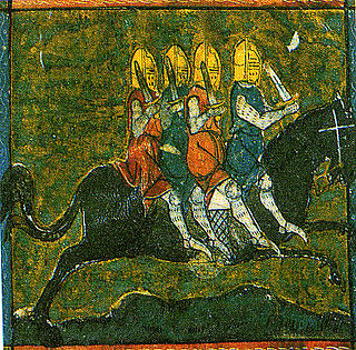
The Four Sons of Aymon, sometimes also referred to as Renaud de Montauban is a medieval tale spun around the four sons of Duke Aymon: the knight Renaud de Montauban, his brothers Guichard, Allard and Richardet, their magical horse Bayard, their adventures and revolt against the emperor Charlemagne. The story had a European success and echoes of the story are still found today in certain folklore traditions.

Reuland Castle is a castle in southeast Belgium, Burg-Reuland, near the border of Germany, probably built after 1148 by the von Reuland nobles.

The diocese of Eupen-Malmedy is a former Belgian Latin Roman Catholic diocese, which existed between 1919 and 1925, and included the East Cantons.

Ouren Castle is a castle ruin in Ouren in the East Cantons of Belgium. It was the ancestral seat of the lineage of the free nobles of Ouren.

Château de Beurthé or Château de Steinbach is a castle situated in Steinbach, Belgium, overlooking a vast park and the Steinbach river.
Heribert Reiners was a German art historian and academic teacher at the Universities in Bonn and Fribourg.
| Wikimedia Commons has media related to Ouren . |