Ouro Sogui Airport

Last updated
Ouro Sogui Airport
Summary
Airport type Public
Serves Matam, Senegal
Location Ouro Sogui
Elevation  AMSL 85 ft / 26 m
Coordinates 15°35′37″N013°19′22″W / 15.59361°N 13.32278°W / 15.59361; -13.32278
Map
Senegal adm location map.svg
Airplane silhouette.svg
MAX
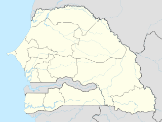
Location within Senegal
Runways
Direction Length Surface
m ft
13/31 1,920 6,299 Paved
[1]

Ouro Sogui Airport( IATA : MAX, ICAO : GOSM) is an airport serving Matam, a city on the Sénégal River and capital of the Matam Region in Senegal. The airport is 10 kilometres (6.2 mi) southwest of Matam, near the town of Ouro Sogui. [2]

An IATA airport code, also known as an IATA location identifier, IATA station code or simply a location identifier, is a three-letter code designating many airports around the world, defined by the International Air Transport Association (IATA). The characters prominently displayed on baggage tags attached at airport check-in desks are an example of a way these codes are used.

ICAO airport code four-letter code designating many airports around the world

The ICAOairport code or location indicator is a four-letter code designating aerodromes around the world. These codes, as defined by the International Civil Aviation Organization and published in ICAO Document 7910: Location Indicators, are used by air traffic control and airline operations such as flight planning.

Airport location where aircraft take off and land

An airport is an aerodrome with extended facilities, mostly for commercial air transport. Airports often have facilities to store and maintain aircraft, and a control tower. An airport consists of a landing area, which comprises an aerially accessible open space including at least one operationally active surface such as a runway for a plane to take off or a helipad, and often includes adjacent utility buildings such as control towers, hangars and terminals. Larger airports may have airport aprons, taxiway bridges, air traffic control centres, passenger facilities such as restaurants and lounges, and emergency services. In some countries, the US in particular, they also typically have one or more fixed-base operators, serving general aviation.

Related Research Articles

This article describes the system of transport in Senegal, both public and private. This system comprises roads, rail transport, water transport, and air transportation.

Ouro Sogui Town in Matam, Senegal

Ouro Sogui or Ourossogui lies in Matam Region in eastern Senegal on the N2 and N3 roads, just south west of Matam on the River Senegal. It is an important market town and transport hub.

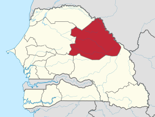
Matam Region Region in Senegal

Matam is a region of Senegal.

Matam may refer to:

Matam, Senegal Town in Matam, Senegal

Matam is the capital town of the Matam Region in north-east Senegal, and lies on the Sénégal River. In the census of 2002, Matam had 14,620 inhabitants. In 2007, according to official estimates, the population of the town had increased to 17,324.

Linguère Town in Louga Region, Senegal

Linguère is a town located in the Linguère Department, Louga Region of Senegal.

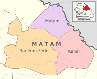
Matam Department Department in Matam Region, Senegal

Matam Department is one of the 45 departments of Senegal, one of the three in the Matam Region in the north-east of the country.

Ranérou Ferlo Department Department in Matam Region, Senegal

Ranérou Ferlo Department is one of the departments of Senegal, located in the Matam Region of the country.

Kanel Department Department in Matam Region, Senegal

Kanel Department is one of the 45 departments of Senegal, located in the Matam Region in the east of the country.

Orkadiere Arrondissement is an arrondissement of the Kanel Department in the Matam Region of Senegal.

Wouro Sidy Arrondissement is an arrondissement of the Kanel Department in the Matam Region of Senegal.


Vélingara Arrondissement is the only arrondissement of the Ranérou Ferlo Department in the Matam Region of east Senegal.

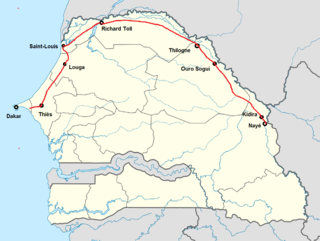
N2 road (Senegal) highway in Senegal

The N2 road is one of the national roads of Senegal. It connects the west and the east of the country in a large arc following the northern frontier from the outskirts of the capital Dakar via Thiès, Louga, Saint-Louis, Richard Toll, Thilogne, Ouro Sogui, Kidira and Nayé on the border with Mali.

Thilogne Town in Matam, Senegal

Thilogne is a small town in north-east Senegal with the status of a commune. It lies in the Matam Department of Matam Region near the border with Mauretania and connected to Dakar via the N2 road.

Ranérou Town in Matam, Senegal

Ranérou is a small town with commune status in north-east Senegal. It is the chief settlement of Ranérou-Ferlo Department in Matam Region and is connected to Dakar and Touba to the west and Ouro Sogui and Mauretania to the east by the N3 road.

N3 road (Senegal) road in Senegal

The N3 road is one of the national roads of Senegal. It connects the west and the east of the country by a direct route across the middle from Thiès in the west via Bambey, Diourbel, Mbacké, Touba, Dahra, Linguère and Ranérou to Ouro Sogui and Malem on the eastern border with Mauritania. The N3 connects with the N2 road at both ends.

N7 road (Senegal) road in Senegal

The N7 road is one of the 7 national roads of Senegal. It connects Ouro Sogui in the north-east of Senegal to Kédougou in the south-east by a route which crosses the Niokolo-Koba National Park.

Agnam Civol is an arrondissement of Matam in Matam Region in Senegal.

Ogo is an arrondissement of Matam in Matam Region in Senegal.

References

  1. Airport information for GOSM / MAX at Great Circle Mapper.
  2. Annotated aerial image showing locations of Matam, Ouro Sougi and airport
National Oceanic and Atmospheric Administration An American scientific agency within the US Department of Commerce that focuses on the oceans and the atmosphere

The National Oceanic and Atmospheric Administration is an American scientific agency within the United States Department of Commerce that focuses on the conditions of the oceans, major waterways, and the atmosphere.

National Weather Service United States weather agency

The National Weather Service (NWS) is an agency of the United States federal government that is tasked with providing weather forecasts, warnings of hazardous weather, and other weather-related products to organizations and the public for the purposes of protection, safety, and general information. It is a part of the National Oceanic and Atmospheric Administration (NOAA) branch of the Department of Commerce, and is headquartered in Silver Spring, Maryland, within the Washington metropolitan area. The agency was known as the United States Weather Bureau from 1890 until it adopted its current name in 1970.

The Aviation Safety Network (ASN) is a website that keeps track of aviation accidents, incidents, and hijackings. Their database contains details of over 10,700 reports. The ASN includes an aviation database with aviation investigations, news, photos, and statistics.