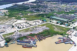
The city of Warri is an oil hub within South-South Nigeria and houses an annex of the Delta State Government House. Warri City is one of the major hubs of the petroleum industry in Nigeria. Warri and her twin city, Uvwie are the commercial capital of Delta State with a population of over 311,970 people in 2006. The city is the indigenous territory of Itsekiri, Urhobo and Ijaw people.
Delta State is a state in the South-South geopolitical zone of Nigeria. Named after the Niger Delta—a large part of which is in the state—the state was formed from the former Bendel State on August 27, 1991. Bordered on the north by Edo State, the east by Anambra and Rivers States, and the south by Bayelsa State across the Niger River for 17 km and the Forçados River for 198 km, while to the west is the Bight of Benin which covers about 160 kilometres of the state's coastline. The State was initially created with 12 local government areas in 1991 which was later extended to 19 and now has 25 local government areas. Asaba as its state capital is located along the River Niger on the northeastern end of the State, while the state's economic centre is the twin cities of Warri and Uvwie.

Cross River State is a state in the South-South geopolitical zone of Nigeria. Named for the Cross River, the state was formed from the eastern part of the Eastern Region on 27 May 1967. Its capital is Calabar, it borders to the north through Benue state, to the west through Ebonyi state and Abia state, and to the southwest through Akwa Ibom state, while its eastern border forms part of the national border with Cameroon. Originally known as the South-Eastern State before being renamed in 1976, Cross River state formerly included the area that is now Akwa Ibom state, which became a distinct state in 1987.
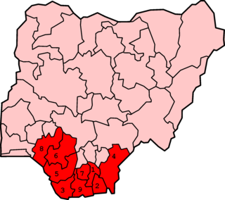
The Niger Delta is the delta of the Niger River sitting directly on the Gulf of Guinea on the Atlantic Ocean in Nigeria. It is located within nine coastal southern Nigerian states, which include: all six states from the South South geopolitical zone, one state (Ondo) from South West geopolitical zone and two states from South East geopolitical zone.
The current conflict in the Niger Delta first arose in the early 1990s over tensions between foreign oil corporations and a number of the Niger Delta's minority ethnic groups who feel they are being exploited, particularly the Ogoni and the Ijaw. Ethnic and political unrest continued throughout the 1990s despite the return to democracy and the election of the Obasanjo government in 1999. Struggle for oil wealth and environmental harm over its impacts has fueled violence between ethnic groups, causing the militarization of nearly the entire region by ethnic militia groups, Nigerian military and police forces, notably the Nigerian Mobile Police. The violence has contributed to Nigeria's ongoing energy supply crisis by discouraging foreign investment in new power generation plants in the region.
Ogbaru is a local government area in Anambra State, south-central Nigeria. The area's local government headquarters is in the port city of Atani.

Uvwie (/hu-we-ɛ/), is a principal Urban Local Government Area in Delta State. It lies along the Warri River and it is one of the twenty-four Urhobo Kingdoms. The entirety of the LGA is conurbated with the city of Warri, making it a greater part of Warri metropolitan area
The Warri Crisis was a series of conflicts in Delta State, Nigeria between 1997 and 2003 between the Itsekiri, the Ijaw, and the Urhobo ethnic groups. Over 200,000 people were displaced by the Warri conflict between 1999 and 2006. Over 700,000 people were displaced during this period by violence in Delta State overall.
Ekeremor is one of the eight local government areas (LGAs) in Bayelsa State, Nigeria. It borders Delta State and has a coastline of approximately 60 km on the Bight of Bonny. Its headquarters are in the town of Ekeremor in the northeast of the area.
The Engenni people live in the Niger Delta region of Nigeria. They are considered to be Edoid based on linguistic grounds. They live in close proximity with Ijaw people. They primarily live in Ahoada west local government area of Rivers state, Nigeria. Although they consider themselves to be Engenni, the Engenni speak an Edoid language. Alagoa (2003) said: “---The penetration of the Niger-Delta by Edoid groups extends to the Epie-Atissa and Engenni of the central and Eastern Niger-Delta----The Epie, along with the Ogbia and other groups of the central and eastern Niger-Delta, are historically united with the Ijaw.” The other groups of the central and eastern Niger-Delta which Professor Ebiegberi Alagoa said that were historically united with the Ijaw, include the Engenni, as shown from his narrative above. The Engenni have close relations with neighbouring Ijaw tribes such as the Zarama and Epie-Atissa.
The Nkoro tribe' of the Ijaw people lives in southeastern Rivers State, Nigeria. Nkoro settlements include: Nkoro, Ayama, Dema, The cultural traditions have been influenced by its proximity to the Andoni, the Bonny. The Nkoro dialect is a dialect of the Ijaw language.

Etche is one of the 23 Local Government Areas of Rivers State and amongst the 13 federal constituencies representing River State in Nigeria's National Assembly and part of the Rivers East Senatorial District. Its people are Igbo and speak Etche dialect.
Eastern Obolo is a Local Government Area (LGA) in southern Nigeria, with its headquarters at Okoroete. It is a coastal local government area in Akwa-Ibom State under great tidal influence from the Bight of Bonny. Eastern Obolo LGA was mapped out of Ikot Abasi LGA by the Federal Government of Nigeria on 4 December 1996 with over 30,000 residents across a total area of approximately 17,000 km2. It comprises 16 villages, divided into two clans, namely Okoroete and Iko. It has ten political wards. All the villages in Eastern Obolo are of the Obolo ethnic group, there exist a common ancestral lineage which allows for peaceful coexistence and inter-relationship amongst them.
Onogbokor is an Isoko-speaking town in the Ndokwa East Local Government Area (LGA), Delta State, Nigeria. Until the creation of Delta State in 1991, it was formerly with the Ndoshimili LGA with headquarters located in Kwale, in the defunct Bendel state. It shares common boundaries with Iyede-Ame in the south, Igeh to the east, Umuolu and Itebiege to the north and Akara-etiti on the west. The town has three quarters: Ushie, Ogbe-ekpako and Ove. Inhabitants of the town dominantly speak the Isoko dialect with few migrant Ụkwụànì speakers. They intermarry Ụkwụànìs, Ijaws and other tribes. As a clan, it has four communities: Ewo-Okpe community, Okporo community, Ewo-eboy community and Obere community. There are migrants from neighbouring nearby communities and pockets of Ijaw fishermen and Hausa petty traders in the clan.

Awo-Omamma, in the Northeast of Niger Delta basin is an oil-rich indigenous Igbo town on the banks of Njaba River. It is a potential tourism hub in the region due to its species of wildlife in Umuezukwe and green vegetation.
The Niger Delta Avengers (NDA) is a militant group in the Niger Delta region of Nigeria. The group publicly announced their existence in March 2016.
The 2016 Niger Delta conflict is an ongoing conflict around the Niger Delta region of Nigeria in a bid for the secession of the region, which was a part of the breakaway state of Biafra. It follows on-and-off conflict in the Christian-dominated southern Niger Delta in the preceding years, as well as an insurgency in the Muslim-dominated northeast.
The Niger Delta Greenland Justice Mandate (NDGJM) is a militant group operating in Nigeria's Niger Delta region. The group was founded on August 2, 2016 in Delta State and is composed mainly of ethnic Urhobos, and a fairly large number of members belonging to the Isoko ethnic group.
