
Ault Park is the fourth-largest park in Cincinnati at 223.949 acres (0.9 km²), owned and operated by the Cincinnati Park Board. It lies in the Mount Lookout neighborhood on the city's east side. The hilltop park has an overlook which commands extensive panoramic views of the Little Miami River valley.

Evanston is a neighborhood in the city of Cincinnati, Hamilton County, Ohio, United States. The population was 9,158 at the 2010 census.

The Loveland Bike Trail is a rail trail in Ohio. It is a section of the Little Miami Scenic Trail within the Loveland, Ohio city limits in Clermont County. Like most of the longer trail, it was built along the right-of-way of the abandoned Little Miami Railroad, on the Little Miami River. Along with 15 other city parks, the trail corridor is maintained by City of Loveland Recreation Commission. The trail was opened in the 1980s and became part of the Little Miami Scenic Trail in 1984. More than 100,000 people accessed the Little Miami Scenic Trail via the Loveland trailhead in 2014.

Camp Washington is a city neighborhood of Cincinnati, Ohio, United States. It is located north of Queensgate, east of Fairmount, and west of Clifton and University Heights. The community is a crossing of 19th-century homes and industrial space, some of which is being converted into loft apartments. The population was 1,343 at the 2010 census.
Daniel Drake Park is a Cincinnati park located on Redbank Road opposite Onondago Avenue in the neighborhood of Kennedy Heights, named after Daniel Drake. The park is owned and operated by the Cincinnati Park Board. The land was purchased by the city in 1957 and expanded in 1959. The shelter was designed by the architects Arend and Arend.
Jackson Hill Park is a Cincinnati park located in the neighborhood of Mt. Auburn, purchased by the city in 1930. The park is owned and operated by the Cincinnati Park Board. In 1983 the park received new landscaping and facilities, including a picnic shelter.
The Frederick H. Alms Memorial Park is a Cincinnati park in the community of Mt. Lookout/Columbia-Tusculum, most often called "Alms Park" for short, owned and operated by the Cincinnati Park Board. Its entrance is located at 650 Tusculum Avenue.
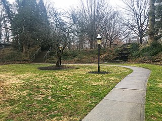
Annwood Park is an urban park in the East Walnut Hills neighborhood of Cincinnati, Ohio, owned and operated by the Cincinnati Park Board. A small park, Annwood was donated to Cincinnati in 1966 and added expanded in 1969. The park is never to be resold and contains no playgrounds or picnic area, as part of the donation agreement. The park is only for walking and sitting, and contains a grotto waterfall and memorial plaque in honor of a local Korean War veteran.
The Bettman Preserve, owned and operated by the Cincinnati Park Board, is a city park in the neighborhoods of Evanston and Hyde Park in Cincinnati, Ohio on Beech Lane. The preserve contains several acres of woodland, and the Bettman Natural Resource Center is home to the city park board's nature education program and library archives. The park was donated in 1977 to the city by Mrs. Arthur M. Bettman, and dedicated to her late husband, a local business leader.

Eden Park is an urban park located in the Walnut Hills and Mt. Adams neighborhoods of Cincinnati, Ohio. The hilltop park occupies 186 acres (0.75 km2), and offers numerous overlooks of the Ohio River valley.
Bracken Woods, owned and operated by the Cincinnati Park Board, is a city park in the neighborhood of Westwood in Cincinnati, Ohio established in 1975. Located on 30.23 acres (122,300 m2) of land, the park is also home to the Robert J. Brodbeck Nature Preserve.
Bradford-Felter Tanglewood, owned and operated by the Cincinnati Park Board, is a 176-acre (710,000 m2) city park in the neighborhood of Mount Airy in Cincinnati, Ohio. The park area was donated to the city in 1938 by Dr. Lloyd F. Felter, at the time consisting of just over 38 acres (150,000 m2) and called Felter Tanglewood. The park board obtained an additional 83 acres (340,000 m2) in 1978, half of which they purchased and the other half donated by Dr. Ray Tully Bradford and his wife. In the years since other land donations and purchases were made, resulting in the current land area.

Burnet Woods, owned and operated by the Cincinnati Park Board, is an 89.3-acre (361,000 m2) city park in Cincinnati, Ohio. The neighborhoods of Clifton and University Heights bound the park on three sides, while the University of Cincinnati west campus forms the southern border. Burnet Woods is bounded by Martin Luther King Drive on the south, Bishop Street on the east, Jefferson and Ludlow Avenues on the north, and Clifton Avenue on the west. Two streets — Brookline Avenue and Burnet Woods Drive — also pass through the park. The original park area was purchased by the city in 1872, with additional purchases made in 1881 and since. In 1875 an artificial lake was added. The park contains a bandstand constructed in 1911, The Lone Star Pavilion, Diggs Fountain Plaza, a playground area and the Trailside Nature Center. The Trailside Nature Center was a museum originally constructed as part of the Works Progress Administration.

Sharptown is an unincorporated community in Whitewater Township, Franklin County, Indiana.

Queensgate is a neighborhood in Cincinnati, Ohio. It sits in the valley of Downtown Cincinnati and has been dominated by industrial and commercial warehouses for most of its history. Cincinnati's nickname of "Porkopolis" started here with hog slaughtering in the early 19th century.

Sayler Park is a neighborhood in Cincinnati, Ohio. The west side neighborhood on the Ohio River is approximately 1 mile (1.6 km) and 2 miles (3.2 km) wide. The population was 2,765 at the 2010 census.
The Federal Reserve Bank of Cleveland Cincinnati Branch Office is one of two Federal Reserve Bank of Cleveland branch offices. The Cincinnati Office of the Federal Reserve Bank of Cleveland provides currency distribution services for financial institutions in multiple Reserve Districts.James M. Anderson is the current chairman.

Piatt Park, is the oldest park in Cincinnati, Ohio. The urban park stretches two blocks between Elm Street and Vine Street on Garfield Place/8th Street. The park is owned and maintained by the Cincinnati Park Board.
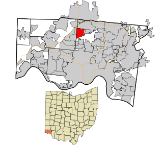
New Burlington is a census-designated place (CDP) in Springfield Township, Hamilton County, Ohio, United States. The population was 5,069 at the 2010 census.
Kennedy Heights Park is an urban park in the Kennedy Heights neighborhood of Cincinnati, Ohio, United States. The 12.4-acre (5.0 ha) park was established in 1930. It features an historic 1937 shelter, playground and soccer field.
