
Hagemans Crossing is an unincorporated community in Union Township, Warren County, Ohio, United States. Located in the western part of the township, it is located on the old Cincinnati and Xenia Pike, now U.S. Route 42, about halfway between Lebanon and Mason. It was at the crossing of the Middletown and Cincinnati Railroad and the Cincinnati, Lebanon and Northern Railway and was about two miles northwest of the M&C's eastern terminus at Middletown Junction.

Evanston is a neighborhood in the city of Cincinnati, Hamilton County, Ohio, United States. The population was 9,158 at the 2010 census.

Mount Lookout, Ohio is one of the Eastern neighborhoods of Cincinnati, just northwest of Linwood and overlooking the Ohio River valley. The neighborhood is named for the Mount Lookout Observatory, which moved to the neighborhood in 1873. The population was 4,814 at the 2010 census.
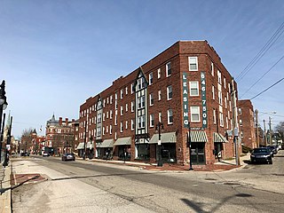
East Walnut Hills is a neighborhood on the Southeast side of Cincinnati, Ohio. The population was 3,794 at the 2010 census.

Westwood is an urban-suburban neighborhood of Cincinnati, Ohio. It is located north of Price Hill, west of Fairmount, and southwest of Mount Airy.
The Frederick H. Alms Memorial Park is a Cincinnati park in the community of Mt. Lookout/Columbia-Tusculum, most often called "Alms Park" for short, owned and operated by the Cincinnati Park Board. Its entrance is located at 650 Tusculum Avenue.
The Bettman Preserve, owned and operated by the Cincinnati Park Board, is a city park in the neighborhoods of Evanston and Hyde Park in Cincinnati, Ohio on Beech Lane. The preserve contains several acres of woodland, and the Bettman Natural Resource Center is home to the city park board's nature education program and library archives. The park was donated in 1977 to the city by Mrs. Arthur M. Bettman, and dedicated to her late husband, a local business leader.
Bracken Woods, owned and operated by the Cincinnati Park Board, is a city park in the neighborhood of Westwood in Cincinnati, Ohio established in 1975. Located on 30.23 acres (122,300 m2) of land, the park is also home to the Robert J. Brodbeck Nature Preserve.
Bradford-Felter Tanglewood, owned and operated by the Cincinnati Park Board, is a 176-acre (710,000 m2) city park in the neighborhood of Mount Airy in Cincinnati, Ohio. The park area was donated to the city in 1938 by Dr. Lloyd F. Felter, at the time consisting of just over 38 acres (150,000 m2) and called Felter Tanglewood. The park board obtained an additional 83 acres (340,000 m2) in 1978, half of which they purchased and the other half donated by Dr. Ray Tully Bradford and his wife. In the years since other land donations and purchases were made, resulting in the current land area.

Kennedy Heights is a residential neighborhood of Cincinnati, Ohio, home to Daniel Drake Park.

Corryville is a neighborhood in Cincinnati, Ohio, east of the University of Cincinnati, southeast of Clifton, south and west of Avondale, northwest of Walnut Hills, and north of Mount Auburn. The population was 3,327 at the 2010 census.
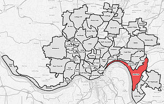
East End is a neighborhood in Cincinnati, Ohio. It is the location of the Cincinnati Municipal Lunken Airport and Columbia Parkway. The population was 1,518 at the 2010 census.

Riverside is a neighborhood in Cincinnati, Ohio. The west side neighborhood is contained in a narrow strip of land along the Ohio River between Sayler Park, Cincinnati and Sedamsville, Cincinnati. It was annexed by the City of Cincinnati in 1893. It is a community that is more industrial than residential. It is home to St. Vincent De Paul Catholic Church. Riverside is also home to the Mount St. Joseph University ball fields.

Sayler Park is a neighborhood in Cincinnati, Ohio. The west side neighborhood on the Ohio River is approximately 1 mile (1.6 km) and 2 miles (3.2 km) wide. The population was 2,765 at the 2010 census.

Downtown Cincinnati is the central business district of Cincinnati, Ohio, as well the economic and symbiotic center of the Cincinnati metropolitan area. It also contains a number of urban neighborhoods in the low land area between the Ohio River and the high land areas of uptown. These neighborhoods include Over-the-Rhine, Pendleton, Queensgate, and West End.

Hartwell is the northernmost neighborhood in Cincinnati, Ohio, centered roughly on the intersections of I-75 and Ronald Reagan Cross County Highway. Its boundaries are a combination of Caldwell Park and Ronald Reagan Cross County Highway to the south, I-75 to the east, and a combination of Millsdale Road and Compton Road to the North. The population was 4,640 at the 2010 census.
Rapid Run Park is an urban park in the Price Hill neighborhood of Cincinnati, Ohio, United States.

Mt. Echo Park is an 84-acre (34 ha) urban park in the Price Hill neighborhood of Cincinnati, Ohio, United States. Located on a hilltop, the park offers scenic overlooks of Downtown Cincinnati and across the Ohio River valley to Northern Kentucky.

Owl's Nest Park is an urban park in the East Walnut Hills and Evanston neighborhoods of Cincinnati, Ohio, owned and operated by the Cincinnati Park Board.
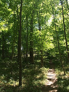
California Woods is a City of Cincinnati municipal park situated in the neighborhood of California. The park consists of 113 acres of forest and has over 50 species of trees. The park is mostly wooded with hiking trails. It has one small building functioning as a nature center, primarily for school and other scheduled visitor groups. The building was constructed in 1938.

