
Andorra is a small, landlocked country in southwestern Europe, located in the eastern Pyrenees mountain range and bordered by Spain and France. With an area of 468 km², it is the sixth smallest country in Europe and also the largest of the European microstates.

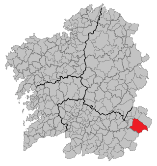
Ourense is a province of Spain, in the southeastern part of the autonomous community of Galicia. It is bordered by the provinces of Pontevedra to the west, Lugo to the north, León and Zamora, to the east, and by Portugal to the south. With an area of 7,278 square km., it is the only landlocked province in Galicia. The provincial capital, Ourense, is the largest population centre, with the rest of the province being predominantly rural.

Lugo is a city in northwestern Spain in the autonomous community of Galicia. It is the capital of the province of Lugo. The municipality had a population of 98,025 in 2018, making it the fourth most populous city in Galicia.

Mañón, also registered in the past as Maañón43°46′09.10″N7°41′08.09″W, is a municipality in north-western Spain in the province of A Coruña, in the autonomous community of Galicia. It belongs to the comarca of Ortegal. Ferrolterra's population represents the third largest concentration of people in Galicia, and its disperse population exceeds 211,000 (2005).

Abadín is a municipality in the province of Lugo, Galicia, Spain. It covers 196.1 km² and has a population of 3,250 for a population density of 16.57/km². It resides in the region of Terra Cha.
Bragança District is a traditional political division of Portugal, in the northeast corner bordering on Spain, covering 7.4% of the nation's continental landmass. As of the 2011 census the total resident population was 136,252, making it the second-least populous district in Portugal, only surpassing Portalegre District.
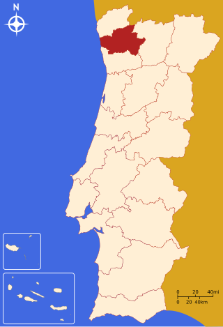
The district of Braga is a district in the northwest of Portugal. The district capital is the city of Braga, and it is bordered by the district of Viana do Castelo in the north, Vila Real in the east, Galicia in the northeast and Porto in the south. Its area is 2,673 km2 (1,032 sq mi) and it has a population of 831,368.
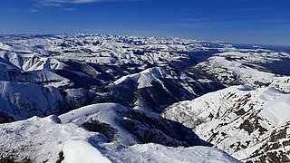
The Cantabrian Mountains or Cantabrian Range are one of the main systems of mountain ranges in Spain. They stretch for over 300 km (180 miles) across northern Spain, from the western limit of the Pyrenees to the Galician Massif in Galicia, along the coast of the Cantabrian Sea. Their easternmost end meets the Sistema Ibérico.

The Minho or Miño is the longest river in Galicia, with a length of 340 kilometres (210 mi). It forms part of the international border between Spain and Portugal. By discharge volume, it is the fourth largest river of the Iberian peninsula after the Douro, Ebro, and Tagus rivers.

The Sierra de Guadarrama is a mountain range forming the main eastern section of the Sistema Central, the system of mountain ranges along the centre of the Iberian Peninsula. It is located between the systems Sierra de Gredos in the province of Ávila, and Sierra de Ayllón in the province of Guadalajara.
A Veiga is a municipality (concello) in the south-east of the province of Ourense in the autonomous community of Galicia, Spain. At 291 km², it is one of the largest concellos in the province. The capital is the town of A Veiga, also known as A Veiga or Santa María da Veiga to distinguish it from other towns and villages in Galicia of the same name. A Veíga is located 150 km from Ourense. The municipality has a population of 1,273 (2005), and a relatively low and decreasing population density.

The state of Himachal Pradesh is spread over an area 55,673 km2 (21,495 sq mi) and is bordered by Jammu and Kashmir and Ladakh on the north, Punjab on the southwest, Haryana on the south, Uttarakhand on the southeast, a small border with Uttar Pradesh in the south, and Tibet on the east. Entire Himachal Pradesh lies in the mountainous Himalaya region, rich in natural resources
Samos is a municipality in the province of Lugo in the autonomous community of Galicia, Spain. It belongs to the comarca of Sarria.

Carballeda de Avia is a municipality in the province of Ourense, in the autonomous community of Galicia, Spain. It belongs to the comarca of O Ribeiro. It is located to the west of the province, 5.7 kilometres (3.5 mi) northwest of Ribadavia off the A-52 road. As of 2012 it had a population of 1487 people. It is a wine-producing area with about 3000 hectares dedicated to vineyards, some of which are at an altitude of 479 metres (1,572 ft). River valleys in the municipality include the Miño, Avia, Arnoia and Barbantiño.

Manta is a municipality and town located in the northeast of the department of Cundinamarca (Colombia), 90 kilometres (56 mi) from Bogotá. It is located in the Almeidas Province in the Tenza Valley. Manta borders to the north Tibiritá, to the west Machetá, to the south Gachetá and to the east Guateque and Guayatá of the department of Boyacá.
Soledad Atzompa is a village in the mountainous central zone in the Mexican state of Veracruz, about 90 km south-east of the state capital Xalapa. It has an area of 65.80 km2 and stands at an elevation of 2260 metres above sea level.

The Issyk is a river in Kazakhstan that crosses the Issyk Lake and the town of Esik. It is a tributary of the river Ili.

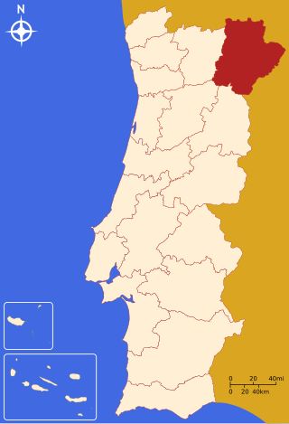
Trás-os-Montes is a geographical, historical and cultural region of Portugal.
The Rivière des Îlets is a tributary of the southern bank of the upper part of the Rivière du Gouffre, flowing in the unorganized territory of Lac-Pikauba, in the Charlevoix Regional County Municipality, in the administrative region of Capitale-Nationale, in the province of Quebec, in Canada.

The topographical relief of Spain is characterized by being quite high, with an average altitude of 660 meters above sea level, quite mountainous compared to other European countries and only surpassed by Switzerland, Austria, Greece and the microstates of Andorra and Liechtenstein. In peninsular Spain, the terrain is articulated around a large Meseta Central that occupies most of the center of the Iberian Peninsula. Outside the plateau, there is the depression of the Guadalquivir river, located in the southwest of the peninsula, and the Ebro river depression, located in the northeast.


