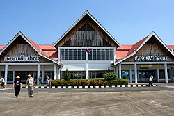
Pakse International Airport ສະຫນາມບິນສາກົນປາກເຊ | |||||||||||
|---|---|---|---|---|---|---|---|---|---|---|---|
 | |||||||||||
| Summary | |||||||||||
| Airport type | Public / Military | ||||||||||
| Owner | Civil Aviation Authority | ||||||||||
| Operator | Military of Laos | ||||||||||
| Location | Pakse, Champasak | ||||||||||
| Opened | 1959 | ||||||||||
| Focus city for | Lao Airlines | ||||||||||
| Elevation AMSL | 351 ft / 107 m | ||||||||||
| Coordinates | 15°08′02″N105°46′55″E / 15.13389°N 105.78194°E | ||||||||||
| Map | |||||||||||
 PKZ/VLPS Location of airport in Laos | |||||||||||
 | |||||||||||
| Runways | |||||||||||
| |||||||||||
Pakse International Airport( IATA : PKZ, ICAO : VLPS) is one of the three international airports in Laos. Pakse is the former southern capital city of the Kingdom of Champasak.