Palais Royale

Last updated
The Palais Royale Palais Royale.jpg
The Palais Royale

Palais Royale is a dance hall in Toronto, Ontario, Canada, located on Lake Shore Boulevard at the foot of Roncesvalles Avenue on Lake Ontario. Originally built as a boat works, it became notable as a night club in the now-defunct Sunnyside Amusement Park, hosting many prominent 'big band' jazz bands. Since the Park's demolition, the building has ceased to be a nightclub, being used for special occasions and concerts. It has recently[ when? ] been remodeled and is in use for special occasions and meetings.

Contents

History

Dean's Boat Works, 1911 Dean's Canoe and Boat Works.jpg
Dean's Boat Works, 1911

In the 1900s and 1910s, the Sunnyside area was undeveloped except for a few waterfront uses. One waterfront business was Dean's Boat House, building canoes, renting boats and providing local boat cruises, located on Lake Shore Road at Queen Street, south-east of High Park. Starting in the 1910s, the waterfront was redeveloped by the Toronto Harbour Commission and all of the waterfront buildings were removed. The waterfront was extended to the south and new buildings were constructed to replace those removed.

The new Dean's Sunnyside Pleasure Boats, a canoe boat-building factory and a supplier to the local Parkdale canoe club was opened in 1922 as part of the new Sunnyside Beach. The new building was designed by the architectural firm of Chapman, Oxley & Bishop, architects who designed the Sunnyside Bathing Pavilion, which opened that same year nearby. The boat-building activities occupied the basement and part of the first floor, which was at shoreline level. The second floor, at ground level from the front, became a dance hall. Although Dean's Pleasure Boats was successful for some time, it eventually went out of business and the Palais became a dance hall only. [1]

Palais Royale, circa 1930 Palais Royale 1930s.jpg
Palais Royale, circa 1930

In 1932 Bill Cuthbert and George Deller took over the Palais Royale and this was the period of its greatest popularity. 'Big bands' such as Duke Ellington and Count Basie, Paul Whiteman and the Dorsey Brothers played there. [2] The largest audience was in 1933, when 3000 people danced to Eddie Duchin's Park Central Orchestra from New York. From 1933 to 1950, Bert Niosi "Canada's King of Swing" and his orchestra were the house band.

Admission was 10 cents plus five cents a dance. Only soft drinks were available and certain dances, such as the jitterbug, were forbidden as they were considered too risqué. Dances were held six nights a week (dancing was not allowed on Sundays).

The land on which the Palais Royale was built was originally leased from the Toronto Harbour Commission in 1922 for 21 years. Cuthbert and Deller renewed the lease in 1944 for another 21 years. [3] They sold their rights to Joe Broderick in 1949. Broderick operated the facility as a dance hall from 1949 to 1966.

1955–present: After the Amusement Park

Desegregating the Dance Hall

In 1955, Sunnyside Amusement Park was demolished for the Gardiner Expressway and Lake Shore Boulevard expansions.

That summer, staff at the Palais Royale intervened to prevent a Black man and a white woman from dancing together, humiliating them and ejecting them onto the street. According to author Ernie Tate: "The couple had openly breached Toronto's unofficial form of segregation under which very little social mixing took place between blacks and whites. The Palais Royale was well known for its racist policies." [4]

In response, activists in the black community organized picket lines to protest the incident. Danny Braithwaite, a young Black activist was one of the protest leaders. Danny would continue his anti-racist organizing at Toronto's school board and in his union local. [5]

The black community was supported by Trotskyists and members of the CCF Youth Forum, who joined the picketers. Feminist activist Pat Schulz recalls that she entered the Palais in July and danced with a Black male partner without being challenged and the Palais was officially desegregated from that point on. [6]

In the period 1956-1959 the hall lost money, but Broderick was showing profits again by 1964. [7] Broderick attempted to negotiate a further lease in 1965 but he was not successful and he sold his rights to the Polish National Union in January 1966. By this time the land had been transferred to the City of Toronto, which had placed the Palais Royale on its list of properties for demolition in 1965. It was then that the City removed the hall's east-side parking lot, formerly the mini-golf course, planting grass and willow trees. However, instead of being demolished, the property was instead designated as a historic site by the City in 1974. [8]

Since then, the hall has been used for concerts by a diverse range of musicians. From Stan Kenton, Benny Louis, Woody Herman, The Carlton Show Band, The Specials, Joe Jackson and Rough Trade around 1980 to concerts by The Pogues, Blur, Blue Rodeo, Sigur Rós, Echo & the Bunnymen, The Sadies, Constantines, Sloan and a The Rolling Stones concert on August 16, 2002. [9] The building was a film location for the 1990 film "Queen of Mean".

On June 18, 1986, the City of Toronto attempted to buy out the lease for the Palais Royale for $82,500, the price at which the property was valued in 1922. The Polish National Union claimed it had spent $236,697 on repairs to the building and refused the offer. [10] In June 1987, the City began legal action to retain control of the property, a process which ended with a decision by the Ontario Court of Appeal on March 28, 1994 which terminated the lease on April 16, 1999. [11]

In 1988 a feature film entitled Palais Royale was released, set and filmed in the nightclub. [12] [13] [14]

The Property was leased to Shoreline Entertainment in 2000, on the condition that repairs and renovations be made to the hall. Shoreline transferred the lease to the Pegasus Group in 2005. [15] The Group spent $3.5 million on renovations, gutting the interior, replacing the windows and rebuilding the rear terrace. Described by Den Farnworth of Goldsmith Borgal Architects as "it's not a true restoration, it's more an adaptive reuse", [16] the renovations attracted some controversy.

On July 22 2006, the Palais Royale hosted its official Grand Re-Opening, and the house band for the evening was Swing Shift Big Band with vocalists Larisa Renee and Dave Statham. City officials and the lead architect for the renovations were in attendance for this celebration and public dance which was promoted heavily by JazzFM 91.1.

Controversies

View of Palais and median parking lot, 2007 Palais-and-parking-lot-2007.JPG
View of Palais and median parking lot, 2007

Critics of the renovation denounced the new design for its destruction of major architectural elements and inept approximation of historical stylings. Detractors claim the new design uses many contemporary elements which are anachronistic on a building of the Art Deco era. Supporters tout the security of its contemporized design, one more likely to attract paying customers and ensure future maintenance, and ultimately, the existence of the structure.

In addition to the design controversy, a controversy erupted over the restoration of the facility's parking lot, which was removed in 1965 [17] and replaced by grass and willow trees, which had grown to mature height in the meantime. Local groups opposed the removal of the trees to repave the parking lot and opposed paving a new parking lot, proposing on-street parking. After public consultations, the City of Toronto has since paved a new parking lot for the hall across the street on former Amusement Park lands between the east and west lanes of Lake Shore Boulevard, and provided a set of stoplights for customers to cross the street to the hall, but preserving the willow trees of the old lot.

Redevelopment plans for the waterfront area include the relocation of Lake Shore Boulevard and the parking lots north, against the Gardiner right-of-way, freeing up park lands along the water.


See also

Related Research Articles

The Frederick G. Gardiner Expressway, commonly known as the Gardiner Expressway or simply the Gardiner, is a partially at grade and elevated municipal expressway in Toronto, Ontario, Canada. Running close to the shore of Lake Ontario, it extends from the foot of the Don Valley Parkway (DVP) in the east, just past the mouth of the Don River, to the junction of Highway 427 and the Queen Elizabeth Way (QEW) in the west, for a total length of 18.0 kilometres (11.2 mi). East of Dufferin Street to just east of the Don River, the roadway is elevated for a length of 6.8 kilometres (4.2 mi), unofficially making it the longest bridge in Ontario. It runs above Lake Shore Boulevard east of Spadina Avenue.

<span class="mw-page-title-main">Parkdale, Toronto</span> Neighbourhood in Toronto, Ontario, Canada

Parkdale is a neighbourhood and former village in Toronto, Ontario, Canada, west of downtown. The neighbourhood is bounded on the west by Roncesvalles Avenue, on the north by the CP Rail line where it crosses Queen Street and Dundas Street. It is bounded on the east by Dufferin Street from Queen Street south, and on the south by Lake Ontario. The original village incorporated an area north of Queen Street, east of Roncesvalles from Fermanagh east to the main rail lines, today known as part of the Roncesvalles neighbourhood. The village area was roughly one square kilometre in area. The City of Toronto government extends the neighbourhood boundaries to the east, south of the CP Rail lines, east to Atlantic Avenue, as far south as the CN Rail lines north of Exhibition Place, the part south of King Street commonly known as the western half of Liberty Village neighbourhood.

<span class="mw-page-title-main">Exhibition Place</span> Publicly owned mixed-use development in Toronto

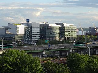
Exhibition Place is a publicly owned mixed-use district in Toronto, Ontario, Canada, located by the shoreline of Lake Ontario, just west of downtown. The 197-acre (80 ha) site includes exhibit, trade, and banquet centres, theatre and music buildings, monuments, parkland, sports facilities, and a number of civic, provincial, and national historic sites. The district's facilities are used year-round for exhibitions, trade shows, public and private functions, and sporting events.

<span class="mw-page-title-main">Roncesvalles, Toronto</span> Neighbourhood in Toronto, Ontario, Canada

Roncesvalles is a neighbourhood in the city of Toronto, Ontario, Canada, centred on Roncesvalles Avenue, a north–south street leading from the intersection of King and Queen Streets to the south, north to Dundas Street West, a distance of roughly 1.7 kilometres. It is located east of High Park, north of Lake Ontario, in the Parkdale–High Park provincial and federal ridings and the municipal Ward 4. Its informal boundaries are High Park to the west, Bloor Street West to the north, Lake Ontario/Queen Street West to the south and Lansdowne Avenue/rail corridor to the east. Originally known as "Howard Park", most of this area was formerly within the boundaries of Parkdale and Brockton villages and was annexed into Toronto in the 1880s.

<span class="mw-page-title-main">Mimico</span> Neighbourhood in Toronto, Ontario, Canada

Mimico is a neighbourhood in Toronto, Ontario, Canada, being located in the south-west area of Toronto on Lake Ontario. It is in the south-east corner of the former Township of Etobicoke, and was an independent municipality from 1911 to 1967.

<span class="mw-page-title-main">Toronto waterfront</span> Shore of Lake Ontario in Toronto, Canada

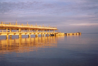
The Toronto waterfront is the lakeshore of Lake Ontario in the city of Toronto, Ontario, Canada. It spans 46 kilometres between the mouth of Etobicoke Creek in the west and the Rouge River in the east.

<span class="mw-page-title-main">Toronto Harbour</span> Bay on the north shore of Lake Ontario, in Toronto, Ontario, Canada

Toronto Harbour or Toronto Bay is a bay on the north shore of Lake Ontario, in Toronto, Ontario, Canada. It is a natural harbour, protected from Lake Ontario waves by the Toronto Islands. Today, the harbour is used primarily for recreational boating, including personal vessels and pleasure boats providing scenic or party cruises. Ferries travel from docks on the mainland to the Islands, and cargo ships deliver aggregates and raw sugar to industries located in the harbour. Historically, the harbour has been used for military vessels, passenger traffic and cargo traffic. Waterfront uses include residential, recreational, cultural, commercial and industrial sites.

<span class="mw-page-title-main">Crystal Beach, Ontario</span> Lakefront community in Fort Erie, Ontario

Crystal Beach is a lakefront community in Fort Erie, Ontario, Canada. As of 2016, it had a population of 8,524. It was named for the "crystal clear" water conditions present when it was founded on the northeast shore of Lake Erie, across from Buffalo.

<span class="mw-page-title-main">Lake Shore Boulevard</span> Street in Toronto

Lake Shore Boulevard is a major arterial road running along more than half of the Lake Ontario waterfront in the city of Toronto, Ontario, Canada. Prior to 1998, two segments of Lake Shore Boulevard were designated as part of Highway 2, with the highway following the Gardiner Expressway between these two sections.

<span class="mw-page-title-main">Scarborough Bluffs</span> Escarpment in Toronto, Canada

The Scarborough Bluffs, also known as The Bluffs, is an escarpment in the Scarborough district of Toronto, Ontario, Canada. There are nine parks along the bluffs, with Bluffers Park being the only one with a beach. Forming much of the eastern portion of Toronto's waterfront, the Scarborough Bluffs stands above the shoreline of Lake Ontario. At its highest point, the escarpment rises 90 metres (300 ft) above the coastline and spans a length of 15 kilometres (9.3 mi).

<span class="mw-page-title-main">Sunnyside, Toronto</span> Lakefront district

Sunnyside is a lakefront district in Toronto, Ontario, Canada. It includes a beach and park area along Lake Ontario's Humber Bay, from west of Exhibition Place to the mouth of the Humber River. The area has several recreation uses, including rowing clubs, sports clubs, picnic areas, playgrounds, a nightclub, a bathing pavilion and public pool. The area is a 3 kilometres (1.9 mi) long strip along the lakeshore, bounded by the Gardiner Expressway and rail lines, which separate it from the Parkdale, Roncesvalles and Swansea neighbourhoods to the north. The name originates in a local farm owned by John Howard, which was situated just to the north, on the location of the current St. Joseph's Health Centre hospital.

<span class="mw-page-title-main">Queen's Quay Terminal</span> Mixed-use residential and commercial in Ontario, Canada

Queen's Quay Terminal is a condominium apartment, office and retail complex in the Harbourfront neighbourhood in Toronto, Ontario, Canada. It was originally built in 1927 as a marine terminal with office, warehouse and cold-storage facilities. When shipping to Toronto declined in the 1960s and 1970s, the building was bought by the Government of Canada to be repurposed along with a section of the industrial waterfront. The Terminal Building itself was rebuilt in the 1980s with the addition of four floors of residential above the original facility, which was converted into retail and office uses. The cold storage wing was demolished and its plant building became The Power Plant gallery and Harbourfront Centre Theatre.

<span class="mw-page-title-main">Humber Bay</span>

Humber Bay is a bay of Lake Ontario south of Toronto, Ontario, Canada. It is located between Ontario Place on the east and Mimico Creek to the west. The bay gives its name to Etobicoke's Humber Bay neighbourhood.

<span class="mw-page-title-main">The Queensway–Humber Bay</span> Neighbourhood in Toronto, Ontario, Canada

The Queensway–Humber Bay, known officially as Stonegate–Queensway, is a neighbourhood in the southwest of Toronto, Ontario, Canada. It is located in the southeast area of the former City of Etobicoke.

<span class="mw-page-title-main">The Palace Pier</span> Site of two towers in Toronto, Ontario, Canada

The Palace Pier is the site of Palace Place and Palace Pier, two cruciform condominium towers tied for the 45th-tallest building in Toronto, Ontario, Canada. They are located at 2045 Lake Shore Boulevard West and 1 Palace Pier Court in the Humber Bay neighbourhood in the former city of Etobicoke.

<span class="mw-page-title-main">Toronto Harbour Commission</span>

The Toronto Harbour Commission (THC) was a joint federal-municipal government agency based in Toronto, Ontario, Canada. The agency managed Toronto Harbour as well as being responsible for major works along the Toronto waterfront. It built both Malton Airport and the Toronto Island Airport in 1939. The agency was founded in 1911 and operated until 1999 when the port operations were transferred to the new Toronto Port Authority (TPA), now PortsToronto.

<span class="mw-page-title-main">Sunnyside Amusement Park</span> Former amusement park in Toronto, Canada

Sunnyside Amusement Park was a popular amusement park in Toronto, Ontario, Canada that ran from 1922 to 1955, demolished in 1955 to facilitate the building of the Metro Toronto Gardiner Expressway project. It was located on the Lake Ontario waterfront at the foot of Roncesvalles Avenue, west of downtown Toronto.

<span class="mw-page-title-main">Jameson Avenue</span> Thoroughfare in Toronto, Ontario

Jameson Avenue is a multi-lane arterial road in the Parkdale neighbourhood in Toronto, Ontario, Canada. It is a north-south roadway from Lake Shore Boulevard to Queen Street. Originally laid out in the 19th century as a two-lane residential street, its traffic and land use has changed considerably from a suburban/semi-rural street to a main arterial connecting to an expressway.

<span class="mw-page-title-main">East Bayfront</span> Neighbourhood in Toronto, Ontario, Canada

East Bayfront, or the East Bayfront Precinct, is an emerging neighbourhood in Toronto, Ontario, Canada. It is currently undergoing a transformation from industrial use to mixed-use as part of Waterfront Toronto's plans to create a residential and commercial district urban core near the lake.

<span class="mw-page-title-main">Martin Goodman Trail</span> Multi-use path along the waterfront in Toronto, Canada

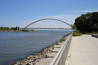
The Martin Goodman Trail is a 56 km (35 mi) multi-use path along the waterfront in Toronto, Ontario, Canada. It traverses the entire lake shore from one end of the city to the other, from Humber Bay Arch Bridge in the west to the Rouge River in the east. The Martin Goodman Trail is part of the 730 km Waterfront Trail around Lake Ontario.

References

  1. Filey (1981), p. 62-63
  2. Toronto Historical Board Plaque, 1985
  3. 1944 lease, Toronto Harbour Commission Archives RG12/3/3950
  4. Tate, Ernest. 2014, pp. 54. "Revolutionary Activism in the 1950s and 60s: Vol 1." London: Resistance Books.
  5. Rooting Out Racism: A Family Affair. By Melodie McCullough. In "Journey Magazine," August 4, 2016.
  6. "Reminiscences of Pat Schulz and the daycare scene." In Mudpie magazine, February, 1984.
  7. Joe Broderick to George A Wilson, Toronto Harbour Commission, September 28, 1964, Toronto Harbour Commission Archives, RG313, Box 363, Folder 17
  8. City of Toronto Minutes 1982, Appendix A, page 523
  9. McLean, Steve (2006-06-05). "Toronto's Palais Royale Is Back And Better Than Ever". Chart .
  10. City of Toronto Minutes, 1987, Executive Committee Report no. 8, pg. 4521
  11. City of Toronto Minutes, 1994, Executive Committee Report 13, pg. 45
  12. Palais Royale at IMDb
  13. "Palais Royale (Smoke Screen) (Smokescreen) (1988)". Rotten Tomatoes . Retrieved 2012-01-01.
  14. "Palais Royale: synopsis". Dusk TV . Retrieved 2012-01-01.
  15. Toronto Staff Report, May 18, 2005
  16. "PDF reprint of Toronto Star article" (PDF). Palais Royale.[ permanent dead link ]
  17. City of Toronto Minutes, 1966, Appendix A, Parks and Recreation Report no. 11, pp. 2237-2239

43°38′12″N79°26′50″W / 43.6367°N 79.447192°W / 43.6367; -79.447192