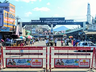
Ettayapuram is a panchayat town in Thoothukudi district of Tamil Nadu, India. It is the birthplace of Tamil poets Mahakavi Bharathiar and Umaru Pulavar. Muthuswami Dikshitar, one of the triads of Carnatic music, was patronized in his final years by the ruler of Ettayapuram.

Tenkasi is a town and headquarters of the Tenkasi district in Indian state of Tamil Nadu.

Madurai district is one of the 38 districts of the state of Tamil Nadu in southeastern India. The city of Madurai serves as the district headquarters. It houses the famous Sri Meenakshi Sundareshwarar temple and is situated on the banks of the river Vaigai. Thiruparankundram is one of the major tourist place in the district. As of 2011, the district had a population of 3,038,252 with a sex-ratio of 990 females for every 1,000 males. Aside from the city of Madurai, the larger towns are Melur, Vadipatti, Thirumangalam, Thirupparankundram, Peraiyur, and Usilampatti. It is an important hub for various film shootings. Alanganallur is a popular spot in the district for Jallikattu, as are Palamedu and Avaniyapuram.
Elumalai is a panchayat town in the district of Madurai, in the Indian state of Tamil Nadu. Originally named Aezhumalai, the town is located near Usilampatti (18 km), Madurai (58 km), Theni (56 km), Peraiyur (24 km) and Tirumangalam (40 km) in the Western Ghats.
Harveypatti is a panchayat town in Madurai district in the Indian state of Tamil Nadu.
Kaveripattinam is a town in Krishnagiri district in the northern part of Tamil Nadu.It is a revenue block in the Krishnagiri district of Tamil Nadu, India. It has a total of 36 panchayat villages.
Othakadai is a panchayat town in Madurai district in the Indian state of Tamil Nadu.

Papanasam is a panchayat town in Thanjavur district in the Indian state of Tamil Nadu. It is located 25 kilometres (16 mi) from Thanjavur and 15 kilometres (9.3 mi) from Kumbakonam. The name literally translates to "Destruction of Sins" in the Tamil language. It is the suburban region of Kumbakonam.
Paravai is a Panchayat town in Madurai district in the Indian state of Tamil Nadu.
Peraiyur is a panchayat town in Madurai district in the Indian state of Tamil Nadu. It is one of the Revenue blocks of Madurai District. Peraiyur is the headquarters of the peraiyur taluk.
Uppiliapuram is a panchayat town in Tiruchirappalli district in the Indian state of Tamil Nadu.

Usilampatti is a town and a second grade municipality of Madurai district in the Indian state of Tamil Nadu. It is also a designated taluk and revenue division.
T. Vadipatti is a panchayat town in the Madurai district in the Indian state of Tamil Nadu.and also known as "west gateway of Madurai.
Vasudevanallur is a town panchayat located 37 km from Tenkasi district in the Indian state of Tamil Nadu. It is located under the Western Ghats. This town is surrounded by farming land. Major occupation of people of this town seems farming especially paddy, sugarcane, lemon and etc., This town is being best for education among the district for both schooling and colleges.
Vedasanthoor is a panchayat town in Dindigul district Located at Indian state of Tamil Nadu. Vedasanthoor town is 21 km (13 mi) from Dindigul city, 25 km (16 mi) from Oddanchatram town, and 82 km (51 mi) from Madurai.
Vilangudi is a panchayat town in Madurai district in the Indian state of Tamil Nadu.

Tirumangalam is a town and municipality in the Madurai District of the Indian state of Tamil Nadu also called as 'Thoongaa Nagarathin Thunai Nagaram'.

Thiruppuvanam is a town in Manamadurai Constituency and also Manamadurai division in the Indian state of Tamil Nadu.

Sendamangalam is a neighbourhood in the city of Namakkal and Taluk in the Indian state of Tamil Nadu. It was merged with the Namakkal Corporation in 2011.
Karaiyippatti is a town and a municipality in the Madurai district in the Indian state of Tamil Nadu. Karaiyippatti is called Thaikramam. It is the biggest taluk within the Madurai District.


