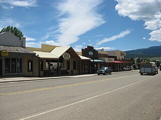
Cimarron is a village in Colfax County, New Mexico, United States which sits on the eastern slopes of the Sangre de Cristo Mountains. The population was 1,021 at the 2010 census, making it the 4th most populated municipality in Colfax County.

Eagle Nest is a village in Colfax County, New Mexico, United States. The population was 290 at the 2010 census. Situated on the Enchanted Circle Scenic Byway, Eagle Nest is a small summer-home and resort area. Originally named Therma, the village was renamed Eagle Nest in the 1930s. The town is located in the Sangre de Cristo Mountains in northern New Mexico near the Colorado-state line.

Pacific Palisades is a coastal neighborhood in the Westside of the city of Los Angeles, California, located among Brentwood to the east, Malibu and Topanga to the west, Santa Monica to the southeast, the Santa Monica Bay to the southwest, and the Santa Monica Mountains to the north. It is about 9 miles northwest of the UCLA campus. The area currently has about 24,651 residents. Of those residents it is estimated that 11,799 are males and 12,852 are females. It is primarily a residential area, with a mixture of large private homes, small houses, condominiums, and apartments.

Cimarron is an unincorporated community and U.S. Post Office in Montrose County, Colorado, United States. The Cimarron Post Office has the ZIP Code 81220.

Mount Sill is one of the fourteeners of the Sierra Nevada in California. It is located in the Palisades, a group of striking rock peaks with a few small glaciers on their flanks. Mount Sill is located 0.6 miles (1 km) east of North Palisade, the high point of the group. The two peaks are connected by a high, rocky ridge, on the north side of which lies the Palisade Glacier. Mount Sill lies on the main Sierra Crest, but is at a point where the crest turns sharply, giving it particularly striking summit views. On one side is Kings Canyon National Park and Fresno County; on the other is the John Muir Wilderness, Inyo National Forest and Inyo County.
Vulture Glacier is located in Banff National Park, Alberta, Canada, northwest of Lake Louise, and can be viewed from the Icefields Parkway. Vulture Glacier is an outflow glacier from the Wapta Icefield, which rests along the Continental Divide. The glacier had an area of 4.9 km² (1.9 mi²) in the 1980s, however, all of the glaciers in the Canadian Rockies have been retreating steadily since the middle of the 19th century.

The Chuska Mountains are an elongate range on the southeast Colorado Plateau and within the Navajo Nation whose highest elevations approach 10,000 feet. The range is about 80 by 15 km. It trends north-northwest and is crossed by the state line between Arizona and New Mexico. The highlands are a dissected plateau, with an average elevation of about 2,740 m (8,990 ft), and subdued topography. The highest point is Roof Butte at 2,994 m (9,823 ft), near the northern end of the range in Arizona. Other high points include the satellite Beautiful Mountain at 2,861 m (9,386 ft) and Lukachukai Mountains at 2,885 m (9,465 ft), both also near the northern end, and Matthews Peak at 2,911 m (9,551 ft). The San Juan Basin borders the Chuskas on the east, and typical elevations in nearby parts of that basin are near 1,800 m (5,900 ft). The eastern escarpment of the mountains is marked by slumps and landslides that extend out onto the western margin of the San Juan Basin. To the north, the Chuskas are separated from the Carrizo Mountains by Red Rock Valley, which is today commonly referred to as Red Valley.

The Beamer Trail is a backpacking trail located on the South Rim of the Grand Canyon National Park, located in the U.S. state of Arizona.

The Cimarron River, flowing entirely in New Mexico, was also known as La Flecha or Semarone. Its headwaters are Moreno, Sixmile, and Cieneguilla creeks in the Sangre de Cristo Mountains, which feed into Eagle Nest Dam. From the dam, it runs for 60 miles (97 km) to below the city of Springer, New Mexico in the Taylor Springs area, where it flows into the Canadian River, the southwestern-most major tributary flowing into the Mississippi River via the Arkansas River sub-basin.

Garcia is an unincorporated community and a U.S. Post Office located in Costilla County, Colorado, United States, just north of the New Mexico border. The Garcia Post Office has the ZIP Code 81134.

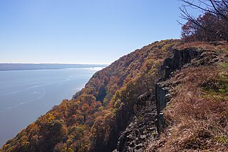
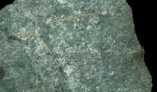
The Palisades Sill is a Triassic, 200 Ma diabase intrusion. It extends through portions of New York and New Jersey. It is most noteworthy for The Palisades, the cliffs that rise steeply above the western bank of the Hudson River. The ideal location and accessibility of the sill, as well as its unique features, have generated much attention from nature enthusiasts, rock climbers, and geologists alike.

Northwestern Oklahoma is the geographical region of the state of Oklahoma which includes the Oklahoma Panhandle and a majority of the Cherokee Outlet, stretching to an eastern extent along Interstate 35, and its southern extent along the Canadian River to Noble County. Northwest Oklahoma is also known by its Oklahoma Department of Tourism designation, Red Carpet Country, which is named after the region's red soil and alludes to the metaphor that the panhandle is a "red carpet" into Oklahoma. The region consists of Cimarron, Texas, Beaver, Harper, Woods, Alfalfa, Grant, Kay, Ellis, Woodward, Major, Garfield, Noble, Dewey, Blaine, and Kingfisher counties.

Elizabethtown is a small unincorporated community in Colfax County, New Mexico, United States. It is located just off New Mexico State Road 38, between the communities of Eagle Nest and Red River. It is just east of the Carson National Forest. The community is a former mining town, and lies northeast of Scully Mountain, and west of Baldy Mountain.

Cimarron Canyon State Park is a state park of New Mexico, United States, located 3 miles (4.8 km) east of Eagle Nest in the Colin Neblett Wildlife Area. The park extends for 8 miles (13 km) along the Cimarron Canyon between Tolby Creek and Ute Park. The Palisades Sill forms spectacular cliffs above the Cimarron River here.

Nares is a former settlement in Fresno County, California. It was located on the Southern Pacific Railroad 0.5 miles (0.80 km) northwest of Helm, at an elevation of 187 feet. It still appeared on maps as of 1925.

Mayhill is a small unincorporated community in Otero County, New Mexico, United States. It is surrounded by the Lincoln National Forest on the eastern slope of the Sacramento Mountains, at the confluence of James Canyon and Rio Penasco, about 17 miles east of Cloudcroft. The elevation is 6581 feet.

The Hakatai Shale is a Mesoproterozoic rock formation that outcrops in the Grand Canyon, Coconino County, Arizona. It consists of colorful strata that exhibit colors that vary from purple to red to brilliant orange on outcrop. The colors are the result of the oxidation of iron-bearing minerals in the Hakatai Shale. It consists of lower and middle members that consist of bright-red, slope-forming, highly fractured, argillaceous mudstones and shale and an upper member composed of purple and red, cliff-forming, medium-grained sandstone. Its thickness, which apparently increases eastwards, varies form 137 to 300 m. In general, the Hakatai Shale and associated strata of the Unkar Group rocks dip northeast (10°-30°) toward normal faults that dip 60° or more toward the southwest. This can be seen at the Palisades fault in the eastern part of the main Unkar Group outcrop area. In addition, thick, prominent, and dark-colored basaltic sills and dikes cut across the purple to red to brilliant orange strata of the Hakatai Shale.

Hook Mountain State Park is a 676-acre (2.74 km2) undeveloped state park located in Rockland County, New York. The park includes a portion of the Hudson River Palisades on the western shore of the Hudson River, and is part of the Palisades Interstate Park system. Hook Mountain State Park is functionally part of a continuous complex of parks that also includes Rockland Lake State Park, Nyack Beach State Park, and Haverstraw Beach State Park.

The Ute Park Fire was a wildfire one mile east of Ute Park, New Mexico in the United States. The fire started on May 31, 2018. The cause remains under investigation. The fire burned a total of 36,740 acres (149 km2) and was contained on June 19, 2018. It threatened the communities of Cimarron and Ute Park, with mandatory evacuations in place from June 1st 2nd, respectively, until June 8th: when both were lifted. The fire destroyed 14 buildings and threatened over 750 structures.


