Pampa Hermosa District, Ucayali

Last updated
Pampa Hermosa District
Localizacion del distrito Pampa Hermosa en la provincia de Ucayali.svg
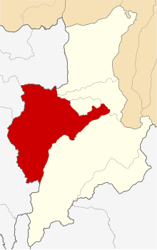
Location of Pampa Hermosa in the Ucayali province
Country Flag of Peru.svg  Peru
Region Loreto
Province Ucayali
FoundedSeptember 15, 1961
Capital Pampa Hermosa
Government
   Mayor Luis Del Castillo Tananta
Area
  Total
7,346.98 km2 (2,836.68 sq mi)
Elevation
132 m (433 ft)
Population
  Total
5,067
  Density0.69/km2 (1.8/sq mi)
Time zone UTC-5 (PET)
UBIGEO 160604

Pampa Hermosa District is one of six districts of the province Ucayali in Peru. [1] Among its indigenous inhabitants are groups of Kichwa-Lamista people who have migrated to the area from Lamas and Biabo since the 1970s. [2]

References

  1. (in Spanish) Instituto Nacional de Estadística e Informática. Banco de Información Distrital Archived 2008-04-23 at the Wayback Machine . Retrieved April 11, 2008.
  2. Chaparro, Anahí (2021). "Los Kichwa de San Martín: impactos de las dinámicas territoriales en las cuencas de los ríos Mayo y Huallaga". In Ministerio de Desarrollo Agrario y Riego Dirección General de Saneamiento de la Propiedad Agraria y Catastro Rural (ed.). TERRITORIOS Y RECURSOS NATURALES DE LOS PUEBLOS INDÍGENAS EN LA AMAZONÍA PERUANA (PDF). Lima: Ministerio de Desarrollo Agrario y Riego Dirección General de Saneamiento de la Propiedad Agraria y Catastro Rural. pp. 107–120. Retrieved 4 June 2023.

7°11′57″S75°51′38″W / 7.1991°S 75.8605°W / -7.1991; -75.8605