Pampean flat-slab

Last updated
Sierras Pampeanas, extra-Andean mountains uplifted by the Pampean flat-slab in the Neogene and Quaternary epochs. Sierras pampeanas1.png
Sierras Pampeanas, extra-Andean mountains uplifted by the Pampean flat-slab in the Neogene and Quaternary epochs.

The Pampean flat-slab is the low angle subduction of oceanic lithosphere beneath Northern Argentina. The Pampean flat-slab is one of three flat slabs in South America, the other being the Peruvian flat-slab and the Bucaramanga flat-slab. [1]

Contents

It is thought that the subduction of the Juan Fernández Ridge, a chain of extinct volcanoes on the Nazca Plate, is the underlying cause of the Pampean flat-slab. [2] [3]

Effects

The shallowing of subducted slab beneath north-central Chile and Argentina is linked to a series of changes in volcanism and tectonics.
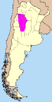
Deformation of crust

The flat-slab has caused an uplift of Sierras Pampeanas which begun first in the north and then moved southwards over millions of years. [2] The oldest noted uplift episode associated with Pampean flat-slab is that of Sierra de Aconquija (27 °S) from 7.6 to 6 million years ago (Ma) in the Late Miocene epoch. [2] This was followed by the uplift of massifs further south such as Sierra de Famatina (29 °S) that rose 4.5 to 4.19 Ma ago. [2] Next to rise was Sierra de Pocho (31 °S) 5.5 to 4.7 Ma ago followed by Sierra de San Luis (33 °S) 2.6 Ma Ago. [2]

At latitude 33 °S deformation of the Andes proper has changed as the slab underneath has gradually shallowed. Thrust front propagation of the Principal Cordillera has increased five-fold in from 15-9 Ma ago to the Pliocene and Early Quaternary. [2] Slightly east the Frontal Cordillera was greatly uplifted 9 million years ago. [2]

Volcanic gap

The Pampean flat-slab has also caused a lull in the volcanism in the Andes seen in the lack of modern volcanoes between the Central Andean Volcanic Zone and the Southern Andean Volcanic Zone. [3] As the flat slab migrated from west to east under South America, so did volcanic activity, until it vanished 1.9 Ma ago, about 750 kilometres (470 mi) from the Pacific, far to the east of ordinary subduction volcanism. [2] Migration of the volcanic activity to the east meant that in the Principal Cordillera magmatic activity ended as early as 8.6 Ma ago. [2]

Related Research Articles

Sierra Nevada de Lagunas Bravas

Sierra Nevada, also known as Sierra Nevada de Lagunas Bravas, is a major ignimbrite-lava dome complex which lies in both Chile and Argentina in one of the most remote parts of the Central Andes. Activity in the complex started in Argentina and formed two stratovolcanoes. Later, 12 or more vents formed, some with craters up to 400 metres (1,300 ft) wide. Lava flows up to 7 kilometres (4.3 mi) long with flow ridges are also found. It covers a total area of 225 km². Radiometric dating has yielded ages of 1.7 ± 0.4 to 0.431 ± 0.012 million years ago. Together with Cerro el Condor and Peinado it forms the Culampaja line, a line of volcanoes that reaches Cerro Blanco. Strong seismic attenuation is observed beneath Sierra Nevada. Hydrothermally altered rocks in Sierra Nevada may be the source of sulfate and As in the Juncalito and Negro rivers.

Antofagasta de la Sierra

Antofagasta de la Sierra is a volcanic field in Argentina. The main type of volcanic edifice in the area are scoria cones, it is formed by the La Laguna, Jote and Alumbrera volcanoes. The first and last of these form a sub-group which is better researched. Various dating methods have yielded ages from several million to several hundred thousand years ago, but some vents appear to be of Holocene age.

Nevado de Longaví

Nevado de Longaví is a volcano in the Andes of central Chile. The 3,242 m (10,636 ft) high volcano lies in the Linares Province, which is part of the Maule Region. It features a summit crater and several parasitic vents. The volcano is constructed principally from lava flows. Two collapses of the edifice have carved collapse scars into the volcano, one on the eastern slope known as Lomas Limpias and another on the southwestern slope known as Los Bueye. The volcano features a glacier and the Achibueno and Blanco rivers originate on the mountain.

Andean Volcanic Belt Volcanic belt in South America

The Andean Volcanic Belt is a major volcanic belt along the Andean cordillera in Argentina, Bolivia, Chile, Colombia, Ecuador, and Peru. It is formed as a result of subduction of the Nazca Plate and Antarctic Plate underneath the South American Plate. The belt is subdivided into four main volcanic zones which are separated by volcanic gaps. The volcanoes of the belt are diverse in terms of activity style, products, and morphology. While some differences can be explained by which volcanic zone a volcano belongs to, there are significant differences within volcanic zones and even between neighboring volcanoes. Despite being a type location for calc-alkalic and subduction volcanism, the Andean Volcanic Belt has a broad range of volcano-tectonic settings, as it has rift systems and extensional zones, transpressional faults, subduction of mid-ocean ridges and seamount chains as well as a large range of crustal thicknesses and magma ascent paths and different amounts of crustal assimilations.

Taapaca Volcano in Chile

Taapaca is a Holocene volcanic complex in northern Chile's Arica y Parinacota Region. Located in the Chilean Andes, it is part of the Central Volcanic Zone of the Andean Volcanic Belt, one of four distinct volcanic chains in South America. The town of Putre lies at the southwestern foot of the volcano.

Geology of Chile

The geology of Chile is a characterized by processes linked to subduction such as volcanism, earthquakes and orogeny. The buildings blocks of Chile's geology assembled during the Paleozoic Era. Chile was by then the southwestern margin of the supercontinent Gondwana. In the Jurassic Gondwana began to split and the ongoing period of crustal deformation and mountain building known as the Andean orogeny began. In the Late Cenozoic Chile definitely separated from Antarctica, the Andes expienced a great rise accomplained by a cooling climate and the onset of glaciations.

Juan Fernández Ridge A volcanic island and seamount chain on the Nazca Plate

The Juan Fernández Ridge is a volcanic island and seamount chain on the Nazca Plate. It runs in a west–east direction from the Juan Fernández hotspot to the Peru–Chile Trench at a latitude of 33° S near Valparaíso. The Juan Fernández Islands are the only seamounts that reach the surface.

Los Patos

Los Patos is a mountain in the Andes mountain range of South America. The peak is located on the international border of the Catamarca Province of Argentina and the Atacama Region of Chile. It has a summit elevation of 6,239 metres (20,469 ft).

Andean orogeny Ongoing mountain-forming process in South America

The Andean orogeny is an ongoing process of orogeny that began in the Early Jurassic and is responsible for the rise of the Andes mountains. The orogeny is driven by a reactivation of a long-lived subduction system along the western margin of South America. On a continental scale the Cretaceous and Oligocene were periods of re-arrangements in the orogeny. Locally the details of the nature of the orogeny varies depending on the segment and the geological period considered.

Geology of Bolivia

The geology of Bolivia comprises a variety of different lithologies as well as tectonic and sedimentary environments. On a synoptic scale, geological units coincide with topographical units. The country is divided into a mountainous western area affected by the subduction processes in the Pacific and an eastern lowlands of stable platforms and shields. The Bolivian Andes is divided into three main ranges; these are from west to east: the Cordillera Occidental that makes up the border to Chile and host several active volcanoes and geothermal areas, Cordillera Central once extensively mined for silver and tin and the relatively low Cordillera Oriental that rather than being a range by its own is the eastern continuation of the Central Cordillera as a fold and thrust belt. Between the Occidental and Central Cordillera the approximately 3,750-meter-high Altiplano high plateau extends. This basin hosts several freshwater lakes, including Lake Titicaca as well as salt-covered dry lakes that bring testimony of past climate changes and lake cycles. The eastern lowlands and sub-Andean zone in Santa Cruz, Chuquisaca, and Tarija Departments was once an old Paleozoic sedimentary basin that hosts valuable hydrocarbon reserves. Further east close to the border with Brazil lies the Guaporé Shield, made up of stable Precambrian crystalline rock.

Aguas Calientes caldera

Aguas Calientes is a major Quaternary caldera in Salta Province, Argentina. It is in the Central Volcanic Zone of the Andes, a zone of volcanism covering southern Peru, Bolivia, northwest Argentina and northern Chile. This zone contains stratovolcanoes and calderas.

Flat slab subduction is characterized by a low subduction angle beyond the seismogenic layer and a resumption of normal subduction far from the trench. A slab refers to the subducting lower plate. Although, some would characterize flat slab subduction as any shallowly dipping lower plate as in western Mexico. Flat slab subduction is associated with the pinching out of the asthenosphere, an inland migration of arc magmatism, and an eventual cessation of arc magmatism. The coupling of the flat slab to the upper plate is thought to change the style of deformation occurring on the upper plate's surface and form basement-cored uplifts like the Rocky Mountains. The flat slab also may hydrate the lower continental lithosphere and be involved in the formation of economically important ore deposits. During the subduction, a flat slab itself may be deformed, or buckling, causing sedimentary hiatus in marine sediments on the slab. The failure of a flat slab is associated with ignimbritic volcanism and the reverse migration of arc volcanism. Multiple working hypotheses about the cause of flat slabs are subduction of thick, buoyant oceanic crust (15–20 km) and trench rollback accompanying a rapidly overriding upper plate and enhanced trench suction. The west coast of South America has two of the largest flat slab subduction zones. Flat slab subduction is occurring at 10% of subduction zones.

Incapillo

Incapillo is a Pleistocene caldera, a depression formed by the collapse of a volcano, in the La Rioja province of Argentina. Part of the Argentine Andes, it is considered the southernmost volcanic centre in the Central Volcanic Zone of the Andes with Pleistocene activity. Incapillo is one of several ignimbritic or calderic systems that, along with 44 active stratovolcanoes, are part of the Central Volcanic Zone.

Jotabeche is a Miocene-Pliocene caldera in the Atacama Region of Chile. It is part of the volcanic Andes, more specifically of the extreme southern end of the Central Volcanic Zone (CVZ). This sector of the Andean Volcanic Belt contains about 44 volcanic centres and numerous more minor volcanic systems, as well as some caldera and ignimbrite systems. Jotabeche is located in a now inactive segment of the CVZ, the Maricunga Belt.

Fueguino

Fueguino is a volcanic field in Chile. The southernmost volcano in the Andes, it lies on Tierra del Fuego's Cook Island and also extends over nearby Londonderry Island. The field is formed by lava domes, pyroclastic cones, and a crater lake.

Pocho volcanic field is a volcanic field in Argentina. It is associated with a crustal lineament known as the Ojo de Agua Lineament.

Wheelwright caldera is a caldera in Chile. It is variously described as being between 11 kilometres (6.8 mi) and 22 kilometres (14 mi) wide and lies in the Central Volcanic Zone of the Andes. A lake lies within the caldera, which is among the largest of the Central Andes. The caldera lies in the region of Ojos del Salado, the world's tallest volcano.

Antofalla

Antofalla is a Miocene-Pliocene volcano in Argentina's Catamarca Province. It is part of the volcanic segment of the Andes in Argentina, and it is considered to be part of the Central Volcanic Zone, one of the volcanic zones of the Andes. Antofalla forms a group of volcanoes that are aligned on and behind the main volcanic arc. Antofalla itself is a remote volcano.

Los Frailes ignimbrite plateau

Los Frailes is an ignimbrite plateau in Bolivia, between the city of Potosi and the Lake Poopo. It belongs to a group of ignimbrites that exist in the Central Andes and which includes the Altiplano–Puna volcanic complex. The plateau covers a surface of 7,500 square kilometres (2,900 sq mi)–8,500 square kilometres (3,300 sq mi) with about 2,000 cubic kilometres (480 cu mi) of ignimbrite.

A magmatic lull is a period of declined magmatic activity in volcanically active regions. They may occur as a result of underthrusting of hinterland lithosphere beneath a volcanic arc, changes in subduction parameters such as relative velocity, direction and slab dip, arc-arc collisions and subduction hinge advance. Individual magmatic lulls may last tens of millions of years between periods of volcanicity.

References

  1. Ramos, Victor A.; Folguera, Andrés (2009-01-01). "Andean flat-slab subduction through time". Geological Society, London, Special Publications. 327 (1): 31–54. doi:10.1144/SP327.3. ISSN   0305-8719.
  2. 1 2 3 4 5 6 7 8 9 Ramos, Victor A.; Cristallini, E.O.; Pérez, Daniel J. (2002). "The Pampean flat-slab of the Central Andes". Journal of South American Earth Sciences . 15: 59–78.
  3. 1 2 Stern, Charles R (December 2004). "Active Andean volcanism: its geologic and tectonic setting". Revista Geológica de Chile . 31 (2): 161–206. doi: 10.4067/S0716-02082004000200001 . ISSN   0716-0208 . Retrieved 2008-11-20.