
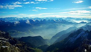
The Rätikon is a mountain range of the Central Eastern Alps, located at the border between Vorarlberg, Liechtenstein and Graubünden. It is the geological border between the Eastern and Western Alps and stretches from the Montafon as far as the Rhine. In the south, the Prättigau is its limit, and in the north, it is the Walgau. In the east, it borders the Silvretta groups. The Rätikon mountain range derives its name from Raetia, a province of the Roman Empire, named after the Rhaetian people.

Broad Peak is the 12th highest mountain in the world at 8,047 metres (26,401 ft) above sea level. The literal translation of "Broad Peak" to Falchan Kangri is not used among the Balti people. The English name was introduced in 1892 by the British explorer Martin Conway, in reference to the similarly named Breithorn in the Alps.

Drei Schwestern is a mountain located on the border of Austria and Liechtenstein. It forms a natural boundary between Liechtenstein and the Austrian state of Vorarlberg.

Wildspitze is the highest mountain in the Ötztal Alps and in North Tyrol, as well as the second highest mountain in Austria after the Großglockner and in terms of prominence is the fourth summit of the Alps and the fifteenth of Europe.

Noshaq is the second highest peak in the Hindu Kush Range at 7,492 m (24,580 ft). It lies in the Wakhan corridor, on the border between Pakistan and Badakhshan Province in Afghanistan. It is the highest point in Afghanistan and is the world's westernmost 7,000 meter massif.

The Grauspitz is a mountain in the Rätikon range of the Alps, located on the border between Liechtenstein and Switzerland. With an elevation of 2,599 metres above sea level, the Grauspitz is the highest mountain in Liechtenstein. It is also the highest summit of the Rätikon range west of the Schesaplana massif.

Hoher Dachstein is a strongly karstic Austrian mountain, and the second highest mountain in the Northern Limestone Alps. It is situated at the border of Upper Austria and Styria in central Austria, and is the highest point in each of those states. Parts of the massif also lie in the state of Salzburg, leading to the mountain being referred to as the Drei-Länder-Berg. The Dachstein massif covers an area of around 20×30 km with dozens of peaks above 2,500 m, the highest of which are in the southern and south-western areas. Seen from the north, the Dachstein massif is dominated by the glaciers with the rocky summits rising beyond them. By contrast, to the south, the mountain drops almost vertically to the valley floor.
The Appenzell Alps are a mountain range in Switzerland on the northern edge of the Alps. They extend into the cantons of Appenzell Ausserrhoden, Appenzell Innerrhoden and St. Gallen and are bordered by the Glarus Alps to the west and the Rätikon to the south-east.
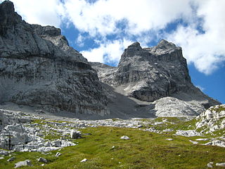
The Sulzfluh is a mountain in the Rätikon range of the Alps, located on the border between Austria and Switzerland. The closest locality is St. Antönien, on the southern side.

The Lechtal Alps are a mountain-range in western Austria, and part of the greater Northern Limestone Alps range. Named for the Lech River which drains them north-ward into Germany, the Lechtal Alps occupy the Austrian states of Tyrol and Vorarlberg and are known for their diverse rock structure.
At 2,744 metres (9,003 ft), the Hochwanner is the second highest mountain in Germany after the Zugspitze. In addition the Hochwanner is the highest peak on the main ridge of the Wetterstein (Wettersteinhauptkamm) running from Gatterl to the Upper Wettersteinspitze above Mittenwald in an east-west direction. From the Hochwanner massif there is an all-round view of the Rein valley (Reintal), the Leutasch valley in Austria, the Gais valley, the Zugspitze, the Mieming Chain, the Jubiläumsgrat, the Karwendel mountains and far into the central Alps.

The Roßkopf is a mountain in the Austrian state of Tyrol in the Kitzbühel Alps. It is 1,731 metres (5,679 ft) high and lies about 7 kilometres due south of Wörgl. To the northeast an arête descends to the Marchbachjoch or Markbachjoch ; another ridge runs northeast to the Kirchköpfl and a third to the Turmkogel to the south. The summit of the Roßkopf is the highest in the local area. It is marked by a large summit cross.

The Western Rhaetian Alps are a mountain range in the central part of the Alps.

Schönfeldspitze is, with an elevation of 2,653 m (AA), the second highest mountain in the Steinernes Meer, a sub-range of the Berchtesgaden Alps. It is located in the Austrian state of Salzburg, close to the German border.

The Wildberg is a 2,788 m (AA) high mountain in the Schesaplana group of the Rätikon mountain range in the Austrian state Vorarlberg.

Tilisuna-Schwarzhorn is a 2,460 m (AA) in the Sulzfluh sub-range of the Rätikon mountain range in the Austrian state Vorarlberg. It has a long ridge from north to south and wide scarps east and west. Besides the main summit, there is a second summit called Kleines Schwarzhorn. Both summits are separated by the col Fürkele. The alpine club hut Tilisunahütte (2208 m) is located near the Tilisuna-Schwarzhorn.


 Summit of Panüeler Kopf

