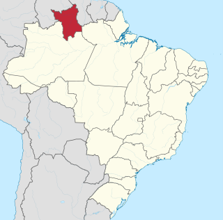
Roraima is one of the 26 states of Brazil. Located in the country's North Region, it is the northernmost and most geographically and logistically isolated state in Brazil. It is bordered by the state of Pará to the southeast, Amazonas to the south and west, Venezuela to the north and northwest, and Guyana to the east.
Mount Roraima is the highest of the Pakaraima chain of tepuis or plateaux in South America. It is located at the junction of Venezuela, Brazil and Guyana. A characteristic large flat-topped mountain surrounded by cliffs 400 to 1,000 meters high. The highest point of Mount Roraima is located on the southern edge of the cliff at an altitude of 2,810 meters in Venezuela, and another protrusion at an altitude of 2,772 meters at the junction of the three countries in the north of the plateau is the highest point in Guyana. The name of Mount Roraima came from the native Pemon people. Roroi in the Pemon language means "blue-green", and ma means "great".
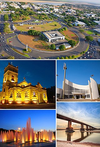
Boa Vista is the capital of the Brazilian state of Roraima. Situated on the western bank of the Branco River, the city lies 220 km (140 mi) from Brazil's border with Venezuela. It is the only Brazilian state capital located entirely north of the equator.

Canaima National Park is a 30,000 km2 (12,000 sq mi) park in south-eastern Venezuela that roughly occupies the same area as the Gran Sabana region. It is located in Bolívar State, reaching the borders with Brazil and Guyana. The park was named a World Heritage Site by UNESCO.

Terra indígena Raposa/Serra do Sol is an indigenous territory in Brazil, intended to be home to the Macuxi people. It is located in the northern half of the Brazilian state of Roraima and is the largest in that country and one of the world's largest, with an area of 1,743,089 hectares and a perimeter of about 1,000 kilometres (620 mi).

The Oyapock or Oiapoque is a 403-kilometre (250 mi) long river in South America that forms most of the border between the French overseas department of French Guiana and the Brazilian state of Amapá.
The Pacaraima or Pakaraima Mountains are a mountain range primarily in southwestern Guyana, and into northern Brazil and eastern Venezuela.

The Ireng River forms part of Guyana's western border with Brazil. It flows through the valleys of the Pakaraima Mountains for most of its length. It is the only major river in Guyana which flows from North to South, up to its confluence into the Takutu River. It is one of the northernmost tributaries of the Amazon river system.
Santa Elena de Uairén is a small Venezuelan city in the state of Bolívar near the border with Brazil and Guyana. It was founded by Lucas Fernández Peña in 1923. The city's name originates from his first daughter, Elena, and Uairén, the river that crosses the city.

Uiramutã is a municipality located in the northeast of the state of Roraima in Brazil. Its population is 10,789 and its area is 8,066 km2. It is the northernmost municipality of Brazil, with Monte Caburaí being the northernmost point. West of this mountain, there is also the Monte Roraima, the tallest mountain in Roraima and in Guyana, located in the triple frontier of Brazil, Guyana and Venezuela. Still, Uiramutã holds the title of the northernmost urban seat of a municipality in Brazil. Its counterparts in the South, West and East are respectively Chuí, state of Rio Grande do Sul; Mâncio Lima, Acre; and João Pessoa, Paraíba.
Arutani is a nearly extinct language spoken in Roraima, Brazil and in the Karum River area of Bolivar State, Venezuela. There are only around 6 speakers left.
São Luís or São Luiz may refer to several places in the Portuguese-speaking world:

The Cotingo River is a river of Roraima state in northern Brazil, a tributary of the Surumu River. It flows through the Raposa Serra do Sol indigenous territory. For many years there has been discussion over building a major hydroelectric power project on the river.
The Uailan River is a river of Roraima state in northern Brazil. It is a tributary of the Maú or Ireng River.

Mount Roraima National Park is a national park in the state of Roraima, northern Brazil.
A riot at the Agricultural Penitentiary of Monte Cristo occurred on 16 October 2016 in Boa Vista, Roraima, Brazil.
The 2017 Brazil prison riots were a confrontation between two criminal organizations, the Primeiro Comando da Capital (PCC) and Comando Vermelho (CV), and their allies within prisons and peripheries of Brazilian cities. Its emergence is linked to the methods of the PCC to conquer new territories for drug trafficking, which involve the collection of insurance and economic centralization and whose rigid pseudo-state organization finds strong resistance from regional criminal organizations, with predominantly decentralized organization.
The Ailã River is a river of Roraima state in northern Brazil. It is located in Monte Caburaí, in the municipality of Uiramutã. Its source is the northernmost point of Brazil.

Miss Roraima is a Brazilian Beauty pageant which selects the representative for the State of Roraima at the Miss Brazil contest. The pageant was created in 1959 and has been held every year since with the exception of 1960-1964, 1969-1970, 1976, 1990-1991, and 1993. The pageant is held annually with representation of several municipalities. Since 2017, the State director of Miss Roraima is, Paulo Silas Valente. Roraima still has yet to win any crowns in the national contest
