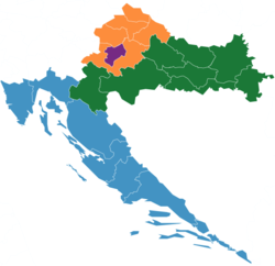
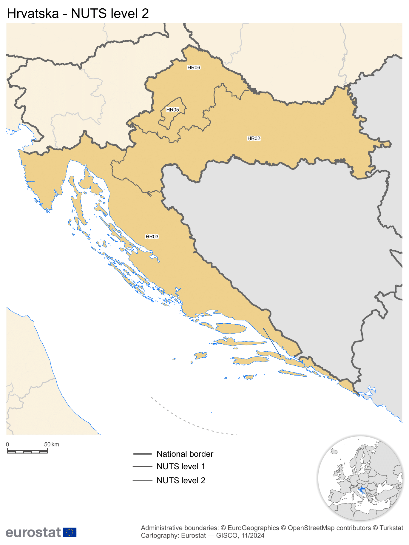
Pannonian Croatia (NUTS-2)

Last updated
Pannonian Croatia
Panonska Hrvatska
Region
Hr-nuts2.png
The region marked in green is referred to as HR02 Pannonian Croatia
Country Flag of Croatia.svg  Croatia
Area
  Total23,220 km2 (8,970 sq mi)
Population
 (2020 estimate) [1]
  Total1,053,690
  Density45/km2 (120/sq mi)
GDP
[2]
  Total€12.274 billion (2022)
NUTS codeHR02

Pannonian Croatia (Croatian : Panonska Hrvatska) is one of the four NUTS-2 regions of Croatia since 2021. [3] [4] The region is located in the continental part of the country, including eight counties of Croatia. The most populated cities in the region are Osijek, Slavonski Brod, Karlovac and Sisak. It accounts for 41% of the country's territory and 26% of the population. Pannonian Croatia is the poorest NUTS-2 region in Croatia with GDP PPS per capita at 40% of EU-27 average.

See also

Related Research Articles

<span class="mw-page-title-main">South Aegean</span> Administrative region of Greece

The South Aegean is one of the thirteen administrative regions of Greece. It consists of the Cyclades and Dodecanese island groups in the central and southeastern Aegean Sea.

<span class="mw-page-title-main">North Aegean</span> Administrative region of Greece

The North Aegean Region is one of the thirteen administrative regions of Greece, and the smallest of the thirteen by population. It comprises the islands of the north-eastern Aegean Sea, called the North Aegean islands, except for Thasos and Samothrace, which belong to the Greek region of Eastern Macedonia and Thrace, and Imbros and Tenedos, which belong to Turkey.

<span class="mw-page-title-main">Nomenclature of Territorial Units for Statistics</span> European Union standard for country subdivisions

Nomenclature of Territorial Units for Statistics or NUTS is a geocode standard for referencing the administrative divisions of countries for statistical purposes. The standard, adopted in 2003, is developed and regulated by the European Union, and thus only covers the EU member states in detail. The Nomenclature of Territorial Units for Statistics is instrumental in the European Union's Structural Funds and Cohesion Fund delivery mechanisms and for locating the area where goods and services subject to European public procurement legislation are to be delivered.

<span class="mw-page-title-main">Småland and the islands</span> National area in Sweden

Småland and the islands is a national area of Sweden. The national areas are a part of the NUTS statistical regions of Sweden. The name derives from the fact that the area covers most of the historical province of Småland with the island provinces of Öland and Gotland, located in the Baltic Sea.

<span class="mw-page-title-main">Economy of the European Union</span>

The economy of the European Union is the joint economy of the member states of the European Union (EU). It is the second largest economy in the world in nominal terms, after the United States and the third one in purchasing power parity (PPP) terms, after China and the United States. The European Union's GDP estimated to be around $19.35 trillion (nominal) in 2024 and $26.64 trillion(PPP) representing around one sixth of the global economy. Germany has the biggest national GDP of all EU countries, followed by France and Italy.

<span class="mw-page-title-main">Development regions of Romania</span> Overview article

The development regions of Romania refer to the eight regional divisions created in Romania in 1998 in order to better co-ordinate regional development as Romania progressed towards accession to the European Union (EU). The development regions correspond to NUTS 2-level divisions in EU member states. Despite becoming increasingly significant in regional development projects, Romania's development regions do not actually have an administrative status and do not have a legislative or executive council or government. Rather, they serve a function for allocating EU PHARE funds for regional development, as well as for collection of regional statistics. They also co-ordinate a range of regional development projects and became members of the Committee of the Regions when Romania joined the EU on January 1, 2007.

<span class="mw-page-title-main">West Sweden</span> National area in Sweden

West Sweden is a national area of Sweden. The national areas are a part of the NUTS statistical regions of Sweden.

<span class="mw-page-title-main">Warsaw metropolitan area</span> Urban area in Masovian Voivodeship, Poland

The Warsaw metropolitan area is the metropolitan area of Warsaw, the capital of Poland. The metropolitan area covers ten counties in the Masovian Voivodeship, with an area of 6,100 km² and a population of around 3.5 million in 2022. The area constitutes a separate NUTS 2 unit, as well as a separate police region with a dedicated Capital Metropolitan Police Headquarters, both of them carved out from the Masovian Voivodeship as an exception, as Polish NUTS 2 areas and police regions are in general identical to the territories of voivodeships.

<span class="mw-page-title-main">Central Greece (region)</span> Administrative region of Greece

Central Greece is one of the thirteen administrative regions of Greece. The region occupies the eastern part of the traditional region of Central Greece, including the island of Euboea. To the south it borders the regions of Attica and the Peloponnese, to the west the region of West Greece and to the north the regions of Thessaly and Epirus. Its capital city is Lamia.

<span class="mw-page-title-main">Severozapaden Planning Region</span> Planning region in Bulgaria

Severozapaden, is a region of Bulgaria. The capital is the city of Pleven. The region has the lowest-ranked economy in Bulgaria and the European Union, with a GDP per capita (PPS) of €9,300 or 31% of EU28 average (2017). It includes five administrative divisions or oblasts: Vidin Province, Vratsa Province, Montana Province, Lovech Province and Pleven Province.

<span class="mw-page-title-main">South Sweden</span> National area in Sweden

South Sweden is a national area of Sweden. The national areas are a part of the NUTS statistical regions of Sweden.

<span class="mw-page-title-main">Upper Norrland</span> National area in Sweden

Upper Norrland is a national area of Sweden. The national areas are a part of the NUTS statistical regions of Sweden.

<span class="mw-page-title-main">Middle Norrland</span> National area in Sweden

Middle Norrland is a national area of Sweden. The national areas are a part of the NUTS statistical regions of Sweden.

<span class="mw-page-title-main">North Middle Sweden</span> National area in Sweden

North Middle Sweden is a national area of Sweden. The national areas are a part of the NUTS statistical regions of Sweden.

<span class="mw-page-title-main">East Middle Sweden</span> National area in Sweden

East Middle Sweden is a national area of Sweden. The national areas are a part of the NUTS statistical regions of Sweden.

<span class="mw-page-title-main">Continental Croatia</span> Region in Croatia

Continental Croatia was one of the two NUTS-2 Regions of Croatia between 2013 and 2021. The region formed the continental part of the country. The most populated cities in the region were Zagreb, Osijek, Slavonski Brod, Karlovac, Sisak and Varaždin. It accounted for 56% of the country's territory and 67% of the population.

<span class="mw-page-title-main">Southern Region, Ireland</span> NUTS 2 Region in Ireland

The Southern Region has been a region in Ireland since 1 January 2015. It is a NUTS Level II statistical region of Ireland.

<span class="mw-page-title-main">Central and Western Lithuania Region</span> NUTS2 Region in Lithuania

Central and Western Lithuania Region is statistical area of the Nomenclature of Territorial Units for Statistics, level NUTS 2. It includes all counties of Lithuania except Vilnius County. Region covers land area of 55,569 km2 and has population of approximately 2.0 million people.

<span class="mw-page-title-main">Northern and Western Region</span> NUTS 2 region in Ireland

The Northern and Western Region has been a region in Ireland since 1 January 2015. It is a NUTS Level II statistical region of Ireland.

<span class="mw-page-title-main">Eastern and Midland Region</span> Second-level NUTS region in Ireland

The Eastern and Midland Region has been defined as a region in Ireland since 1 January 2015. It is a NUTS Level II statistical region of Ireland.

References

  1. "Population - review by counties" (XLSX). Dzs.hr. Retrieved 4 February 2022.
  2. "EU regions by GDP, Eurostat" . Retrieved 18 September 2023.
  3. "NUTS2021" (XLSX). Ec.europa.eu. Retrieved 4 February 2022.
  4. "Changes from NUTS 2016 to NUTS 2021 including statistical regions, level 2" (PDF). Ec.europa.eu. Retrieved 4 February 2022.