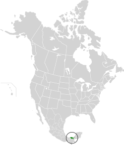
Tabasco, officially the Free and Sovereign State of Tabasco, is one of the 32 Federal Entities of Mexico. It is divided into 17 municipalities and its capital city is Villahermosa.

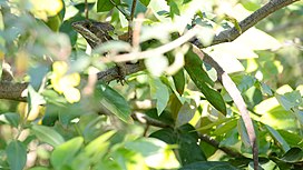
The hickatee or in Spanish tortuga blanca, also called the Central American river turtle, is the only living species in the family Dermatemydidae. The species is found in the Atlantic drainages of Central America, specifically Belize, Guatemala, southern Mexico and probably Honduras. It is a relatively large-bodied species, with records of 60 cm (24 in) straight carapace length and weights of 22 kg (49 lb); although most individuals are smaller. This is a herbivorous and almost completely aquatic turtle that does not even surface to bask. Bizarrely for reptiles, the eggs can remain viable even after being underwater for weeks -in the recent past, some scientists mistakenly claimed it nests underwater, likely due to visiting Central America during a frequent flood, when nests are often submerged.

The Usumacinta River is a river in southeastern Mexico and northwestern Guatemala. It is formed by the junction of the Pasión River, which arises in the Sierra de Santa Cruz and the Salinas River, also known as the Rio Chixoy, or the Rio Negro, which descends from the Sierra Madre de Guatemala. It defines part of the border between Guatemala and the Mexican state of Chiapas, then continues its northwesterly course, meandering through the Mexican state of Tabasco to the Gulf of Mexico.

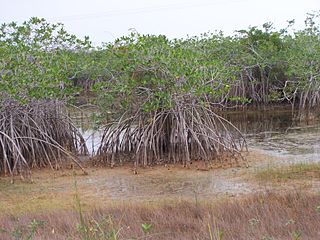
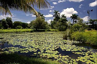
Laguna de Términos is the largest tidal lagoon by volume located entirely on the Gulf of Mexico, as well as one of the most biodiverse. Exchanging water with several rivers and lagoons, the Laguna is part of the most important hydrographic river basin in Mexico. It is important commercially, as well as ecologically by serving as a refuge for extensive flora and fauna; its mangroves play an important role as a refuge for migratory birds.

The Sierra de la Laguna pine–oak forests are a subtropical coniferous forest ecoregion, found in the Sierra de la Laguna mountain range at the southern tip of the Baja California Peninsula, Mexico.

The Petén–Veracruz moist forests is an ecoregion of the tropical and subtropical moist broadleaf forest biome found in Belize, Guatemala, and Mexico.

The Yucatán moist forests are an ecoregion of the tropical and subtropical moist broadleaf forests biome, as defined by the World Wildlife Fund.
The Belizean Coast mangroves ecoregion covers the brackish and salt-water habitats along the Caribbean Sea coast of Belize, and of Amatique Bay in Guatemala; small parts in the border with Mexico are also present on this ecoregion. The mangroves are partially protected from the open sea by the Belize Barrier Reef, and this ecoregion is distinct from the reef-based Belizean Reef mangroves ecoregion offshore. There is a large population of the vulnerable West Indian manatee in the area. It covers an area of around 2850 km2.

The Mapimí Biosphere Reserve is a UNESCO Biosphere Reserve located in the state of Durango in northern Mexico. It is one of three biosphere reserves representing the Chihuahuan Desert. The 342,388 hectares (1,321.97 sq mi) reserve is situated between the Neotropical and Nearctic biogeographic realms, in the Bolsón de Mapimí 1,150 metres (3,770 ft) above sea level. It contains three core areas in the Sierra de la Campana, the Laguna de las Palomas, a salt lagoon, and a desert habitat called Dunas de la Soledad. It comprises fragile warm desert and semi-desert ecosystems and rich, highly adapted but vulnerable plant systems, mainly xerophytic matorral scrub, and animal species such as the puma, mule deer, sandhill crane and the kit fox or zorrita del desiert along with scrub and desert grasslands.
La Encrucijada Biosphere Reserve is a UNESCO Biosphere Reserve situated in the Pacific Coastal Lowlands physiographic region of Mexico. It covers 144,848 hectares (559.26 sq mi) stretching over six municipalities in the Costa de Chiapas. It is composed of two large coastal lagoon systems that correspond to two core areas, and a wide variety of natural ecosystems including mangroves, zapotonales, tule swamps and marshes, as well as patches of tropical seasonal forest, coastal dunes and palm trees.

The Mesoamerican Gulf-Caribbean mangroves ecoregion covers the series of disconnected mangrove habitats along the eastern coast of Central America. These salt-water wetlands are found in river deltas, lagoons, and low-lying areas facing the Gulf of Mexico and Caribbean Sea, from Tampico, Mexico to central Panama. The mangroves are areas of high biodiversity and endemism. Many of the sites are protected as national parks or nature reserves.

The Petenes mangroves ecoregion covers mangrove habitat along the Gulf of Mexico coast of southern Mexico, where Campeche state and Yucatan state meet, centering on the Celestun Lagoon inland from the barrier-island town of Celestún. Because the region has relatively little rainfall and no rivers feeding the lagoons, the freshwater to support the mangrove ecosystem springs from underground aquifers. The area is important for migratory birds, and as a nesting area for sea turtles. The area around the Celestun Lagoon is protected by the Ría Celestún Biosphere Reserve, a UNESCO Biosphere Reserve, and Los Petenes Biosphere Reserve in Campeche.

The Usumacinta mangroves ecoregion covers the mangrove forests ont the Gulf Coast of Mexico, around the margins of the Laguna de Términos. The "Ends" in the name refer to the mouths of the rivers that empty into the lagoon, including the Usumacinta River. This region, which is due south of the mouth of the Mississippi River across the Gulf of Mexico, receives an estimated one-third of the wintering birds migrating on the Mississippi Flyway. It is estimated that the lagoon supports 90 endangered species.

The Alvarado mangroves ecoregion covers a series of mangrove forest areas along the Gulf of Mexico coast of the states of Tamaulipas and Veracruz in Mexico. they are the most northerly mangroves in the western Gulf. The largest tracts of mangrove swamps occur at the mouths of rivers, and nearby coastal lagoon.
The Cuban wetlands is a flooded grasslands and savannas ecoregion on the island of Cuba and nearby smaller islands. The ecoregion covers 5,631 km2 (2,174 sq mi), about 4% of the island's area.
The Guadalupe Island Biosphere Reserve,, is in the Pacific Ocean and part of Baja California state of Mexico. The Reserve consists of Guadalupe Island and several small islands nearby plus a large expanse of surrounding ocean. The Reserve was created by the government of Mexico on 25 April 2005 and is located 250 kilometres (160 mi) from the mainland. The Reserve is 4,770 square kilometres (1,840 sq mi) in size of which 263 square kilometres (102 sq mi) is land and the remainder is water.
Ría Celestun Biosphere Reserve is a biosphere reserve in Mexico. It is located on the northwestern Yucatán Peninsula in the states of Yucatán and Campeche. The reserve is home to extensive mangrove wetlands, and rich in birds and other wildlife.
Los Petenes Biosphere Reserve is a biosphere reserve in Mexico. It is located on the western Yucatán Peninsula in the state of Campeche. The reserve is home to extensive mangrove wetlands, and rich in birds and other wildlife.
The Chumpan River is a river in Campeche state of southern Mexico. It originates along the border between Campeche and Tabasco, and flows generally northwards to empty into Balchacah Lagoon, a subsidiary lagoon to Laguna de Términos, which connects to the Gulf of Mexico. Its chief tributaries are the San Joaquin and Salsipuedes rivers.
The Palizada River is a river in Mexico. It is a distributary of the Usumacinta River. It branches from the lower Usumacinta and flows northeastwards, emptying into a complex of lagoons connected to Laguna de Términos, a coastal lagoon of the Gulf of Mexico.