Paprat

Last updated
Paprat
Папрат
Village
Country Flag of Bulgaria.svg  Bulgaria
Province Kardzhali Province
Municipality Dzhebel
Time zone EET (UTC+2)
  Summer (DST) EEST (UTC+3)

Paprat is a village in Dzhebel Municipality, Kardzhali Province, southern Bulgaria. [1]

Dzhebel Municipality Municipality in Kardzhali, Bulgaria

Dzhebel Municipality is a municipality in Kardzhali Province, Bulgaria. It includes the town of Dzhebel and a number of villages.

Kardzhali Province Province in Bulgaria

Kardzhali District is a province of southern Bulgaria, neighbouring Greece with the Greek regional units of Xanthi, Rhodope, and Evros to the south and east. It is 3209.1 km² in area. Its main city is Kardzhali.

Bulgaria country in Southeast Europe

Bulgaria, officially the Republic of Bulgaria, is a country in Southeast Europe. It is bordered by Romania to the north, Serbia and North Macedonia to the west, Greece and Turkey to the south, and the Black Sea to the east. The capital and largest city is Sofia; other major cities are Plovdiv, Varna and Burgas. With a territory of 110,994 square kilometres (42,855 sq mi), Bulgaria is Europe's 16th-largest country.
Honours

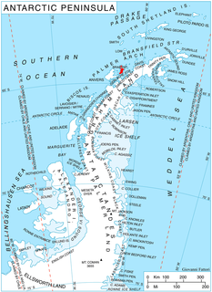
Paprat Peak on Brabant Island, Antarctica is named after the village.

Paprat Peak

Paprat Peak is the ice-covered peak of elevation 650 m in Solvay Mountains on Brabant Island in the Palmer Archipelago, Antarctica. It surmounts Koch Glacier to the east, Chiriguano Bay to the south and Jenner Glacier to the northwest.

Brabant Island second largest island of the Palmer Archipelago within the British Antarctic Territory

Brabant Island is the second largest island of the Palmer Archipelago within the British Antarctic Territory, lying between Anvers Island and Liège Island. Brabant Island is 59 km (37 mi) long north-south, 30 km (19 mi) wide, and rises to 2,520 m (8,268 ft) in Mount Parry. The interior of the island is occupied by two mountain ranges, Solvay Mountains in its southern part and Stribog Mountains in its central and northern parts.

Related Research Articles

Tsvyatovo is a village in Dzhebel Municipality, Kardzhali Province, southern Bulgaria.

Kos is a village in Momchilgrad Municipality, Kardzhali Province, southern Bulgaria.

Baratsi is a village in Krumovgrad Municipality, Kardzhali Province, southern Bulgaria.

Kovil is a village in Krumovgrad Municipality, Kardzhali Province, southern Bulgaria.

Pashintsi is a village in Krumovgrad Municipality, Kardzhali Province, southern Bulgaria.

Chakalarovo is a village in Kirkovo Municipality, Kardzhali Province, southern Bulgaria.

Chichevo is a village in Kirkovo Municipality, Kardzhali Province, southern Bulgaria.

Erovete is a village in Kirkovo Municipality, Kardzhali Province, southern Bulgaria.

Rastnik is a village in Kirkovo Municipality, Kardzhali Province, southern Bulgaria.

Yakovitsa is a village in Kirkovo Municipality, Kardzhali Province, southern Bulgaria.

Bozhak is a village in Kardzhali Municipality, Kardzhali Province, southern Bulgaria.

Chereshitsa is a village in Kardzhali Municipality, Kardzhali Province, southern Bulgaria.

Kobilyane is a village in Kardzhali Municipality, Kardzhali Province, southern Bulgaria.

Kokoshane is a village in Kardzhali Municipality, Kardzhali Province, southern Bulgaria.

Ridovo is a village in Kardzhali Municipality, Kardzhali Province, southern Bulgaria.

Strazhevtsi, Postalar in Turkish and Стражевци in Bulgarian is a village in Kardzhali,Kircaali in Turkish and Кърджали in Bulgarian) Municipality, Kardzhali Province, southern Bulgaria.

Visoka Polyana is a village in the Kardzhali Municipality, which is in the Kardzhali Province, in southern Bulgaria. As of 1 January 2007, the population of Visoka Polyana is 224 people.

Topolchane is a village in Kardzhali Municipality, Kardzhali Province, southern Bulgaria.

Veleshani is a village in Kardzhali Municipality, Kardzhali Province, southern Bulgaria.

Varbentsi is a village in Kardzhali Municipality, Kardzhali Province, southern Bulgaria.

References

  1. Guide Bulgaria, Accessed Nov 16, 2014

Coordinates: 41°31′00″N25°17′00″E / 41.5167°N 25.2833°E / 41.5167; 25.2833

Geographic coordinate system Coordinate system

A geographic coordinate system is a coordinate system that enables every location on Earth to be specified by a set of numbers, letters or symbols. The coordinates are often chosen such that one of the numbers represents a vertical position and two or three of the numbers represent a horizontal position; alternatively, a geographic position may be expressed in a combined three-dimensional Cartesian vector. A common choice of coordinates is latitude, longitude and elevation. To specify a location on a plane requires a map projection.