Paralia Panteleimonos

Last updated
The beach of Panteleimon. Panteleimon Paralia.jpg
The beach of Panteleimon.

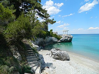
Paralia Panteleimonos (Greek : Παραλία Παντελεήμονος) is a settlement of the former municipal district of Panteleimonas, the former municipality of East Olympos, which belongs to the municipality of Dio-Olympos, and is one of the 16 total coast of the regional unit. [1]

Greek language language spoken in Greece, Cyprus and Southern Albania

Greek is an independent branch of the Indo-European family of languages, native to Greece, Cyprus and other parts of the Eastern Mediterranean and the Black Sea. It has the longest documented history of any living Indo-European language, spanning more than 3000 years of written records. Its writing system has been the Greek alphabet for the major part of its history; other systems, such as Linear B and the Cypriot syllabary, were used previously. The alphabet arose from the Phoenician script and was in turn the basis of the Latin, Cyrillic, Armenian, Coptic, Gothic, and many other writing systems.

East Olympos Place in Greece

East Olympos, or Anatolikos Olympos, is a former municipality in Pieria regional unit, Greece. Since the 2011 local government reform it is part of the municipality Dio-Olympos, of which it is a municipal unit. The municipal unit has an area of 152.939 km2. Population 8,343 (2011). The seat of the municipality was in Leptokarya.

It is about 36 km from Katerini, 56 km from Larissa and is southeast of the county. According to recent archaeological excavations in the area during the construction of the railway tunnel under the castle, were findings of ancient Greek town Ηράκλεια (Heracleia). [2]

Katerini Place in Greece

Katerini is a city in Central Macedonia, Greece, the capital of Pieria regional unit. It lies on the Pierian plain, between Mt. Olympus and the Thermaikos Gulf, at an altitude of 14 m. The city has a population of 85,851 and it is the second most populous urban area at the Region of Macedonia after Thessaloniki. The close distance between two cities (68km), has been beneficial for Katerini's development over recent years. Katerini is accessible from the main Thessaloniki–Athens highway GR-1/E75 and the Egnatia Odos to the north. It is served by Intercity, Proastiakos and local trains on the main railway line from Athens to Thessaloniki and there is a comprehensive regional and national bus service with its hub in the city.

Larissa Place in Greece

Larissa is the capital and largest city of the Thessaly region, the fourth-most populous in Greece according to the population results of municipal units of 2011 census and capital of the Larissa regional unit. It is a principal agricultural centre and a national transport hub, linked by road and rail with the port of Volos, the cities of Thessaloniki and Athens. Larissa, within its municipality, has 162,591 inhabitants, while the regional unit of Larissa reached a population of 284,325. The urban area of the city, although mostly contained within the Larissa municipality, also includes the communities of Giannouli, Platykampos, Nikaia, Terpsithea and several other suburban settlements, bringing the wider urban area population of the city to about 174,012 inhabitants and extends over an area of 572.3 km2 (221.0 sq mi).

Ancient Greek Version of the Greek language used from roughly the 9th century BCE to the 6th century CE

The Ancient Greek language includes the forms of Greek used in Ancient Greece and the ancient world from around the 9th century BCE to the 6th century CE. It is often roughly divided into the Archaic period, Classical period, and Hellenistic period. It is antedated in the second millennium BCE by Mycenaean Greek and succeeded by medieval Greek.

There is a summer residence of the inhabitants of Neos Panteleimonas and tourist resort, which is flooded with tourists during the period May and June. It is located just below of the castle of Platamon, and for this reason sometimes is called "Κάστρο", Kastro (Castle). The coastal beach is 3 km. Each year awarded with the Blue Flag by the European Union, because of the purity of water and the sandy coast.

Neos Panteleimonas village in Greece

Neos Panteleimonas is a settlement of the former municipality of East Olympos, which is part of the municipality of Dio-Olympos, in the Pieria regional unit, Central Macedonia, Greece.

European Union Economic and political union of European states

The European Union (EU) is a political and economic union of 28 member states that are located primarily in Europe. It has an area of 4,475,757 km2 (1,728,099 sq mi) and an estimated population of about 513 million. The EU has developed an internal single market through a standardised system of laws that apply in all member states in those matters, and only those matters, where members have agreed to act as one. EU policies aim to ensure the free movement of people, goods, services and capital within the internal market, enact legislation in justice and home affairs and maintain common policies on trade, agriculture, fisheries and regional development. For travel within the Schengen Area, passport controls have been abolished. A monetary union was established in 1999 and came into full force in 2002 and is composed of 19 EU member states which use the euro currency.

See also

Paralia Skotinas village in Greece

Paralia Skotinas is a seaside settlement which is part of the municipality of Dio-Olympos, in the Pieria regional unit, Central Macedonia, Greece. It is 6 κm from Leptokarya, 1 km from Paralia Panteleimonos (Castle) and 1κm from Skotina. In this point its view of the Castle of Platamon, is unique.

Platamon Place in Greece

Platamon, or Platamonas, is a town and sea-side resort in south Pieria, Central Macedonia, Greece. Platamon has a population of about 2,000 permanent inhabitants. It is part of the Municipal unit of East Olympos of the Dio-Olympos municipality.

Neoi Poroi Place in Greece

Neoi Poroi is a coastal village of the Dio-Olympos municipality. Before the 2011 local government reform it was part of the municipality of East Olympos, of which it was a municipal district. The settlement of Neoi Poroi had a population of 733 inhabitants as of 2011. Neoi Poroi is a part of the community of Poroi. The main occupation in the village is tourism. A model development plan, has huge streets and squares.

Related Research Articles

Vartholomio Place in Greece

Vartholomio is a town and a former municipality in Elis, West Greece, Greece. Since the 2011 local government reform it is part of the municipality Pineios, of which it is a municipal unit. The municipal unit has an area of 60.696 km2. Its population was 5,899 in 2011, of which 3,603 lived in the town proper. The municipal unit covers the southern part of the hilly Kyllini peninsula, and the plains to the southeast. The town Vartholomio is in the plains, on the right bank of the river Pineios, which flows into the Ionian Sea south of the town.

Paralia, Pieria Place in Greece

Paralia is a tourist seaside settlement and a former municipality in the eastern part of the Pieria regional unit, Greece. Since the 2011 local government reform it is part of the municipality Katerini, of which it is a municipal unit. The seat of the municipality was in Kallithea. The 2011 census reported a population of 1,124 for the village of Paralia, and 6,803 for the municipal unit. The municipal unit has an area of 24.344 km2, the community 1.849 km2.. Paralia Katerinis actually translated "Beach of Katerini" and is the closest beach to the capital city of Katerini.

Plomari Place in Greece

Plomari is a town and a former municipality on the island of Lesbos, North Aegean, Greece. Since the 2011 local government reform it is part of the municipality Lesbos, of which it is a municipal unit. It is the only sizable coastal settlement in the south, and the second largest town on Lesbos. The municipal unit of Plomari is the southernmost on Lesbos island and has a land area of 122.452 km² and a 2011 census population of 5,602. Its largest towns or villages are Plomári, the former municipal seat, Plagiá (529), Palaiochóri (314), Megalochóri (325), and Akrási (214).

Thinali Place in Greece

Thinali is a former municipality on the island of Corfu, Ionian Islands, Greece. Since the 2011 local government reform it is part of the municipality Corfu, of which it is a municipal unit. It is located in the northernmost part of the island of Corfu, in the middle of the north coast. It was the largest municipality on the island at 77.899 km². Its population was 5,226 at the 2011 census. The seat of the municipality was the town of Acharavi. Its largest other towns are Nymfes and Epískepsi (332). It is located northwest of the city of Corfu. Last mayor of Thinali was Varelis Spiridon from village Lafki.

Leptokarya Place in Greece

Leptokarya is a town in Pieria regional unit, Central Macedonia, Greece, former seat of East Olympos municipality, which is part of the municipality of Dio-Olympos. The distance from Katerini is 26 km and the population of the village was 4,225 inhabitants as of 2011.

Paralia Distomou Place in Greece

Paralia Distomou, also known as Aspra Spitia, is a town in the municipal unit Distomo-Arachova-Antikyra, in Boeotia, Greece. In 2011, its population was 1,578.

Paralia, Achaea Place in Greece

Paralia is a town and a former municipality in Achaea, West Greece, Greece.

Palaios Panteleimonas is a mountain village of the former municipality of East Olympos, which is part of the municipality of Dio-Olympos, in the Pieria regional unit, Central Macedonia, Greece.

Skotina Place in Greece

Skotina is a rural settlement of the former municipality of East Olympos, itself part of the municipality of Dio-Olympos, in the Pieria regional unit, Central Macedonia, Greece.

Vrontou, Pieria human settlement in Greece

Vrontou is a town of the former Municipality of Dio, which is part of the municipality of Dio-Olympos, in the Pieria regional unit, Central Macedonia, Greece, at an altitude of 120 meters, with 1,902 inhabitants. There are several medieval and post-medieval churches in Vrontou.

Pyrgetos is a village in the Larissa regional unit, Thessaly, Greece. It was the seat of the former municipality of Kato Olympos, which has been part of the municipality of Tempi since 2011. Its elevation is 140 m. In 2011 its population was 1,463. It is located on the southeastern slopes of Mount Olympus, 4 km east of Rapsani, 34 km northeast of Larissa and 40 km south of Katerini. It is situated near the Delta of Pineios, which is a protected area, part of the Natura 2000 network. Remains of a Venetian bridge are situated at the place Leivadi.

Paralia Koulouras is a beach of Larissa regional unit.

Panteleimonas, Pieria Place in Greece

Panteleimonas is a community of the Dio-Olympos municipality. Before the 2011 local government reform it was part of the municipality of East Olympos, of which it was a municipal district. The 2011 census recorded 911 inhabitants in the community.

Paralia Korinou Place in Greece

Paralia Kornou is a village of the Katerini municipality. Before the 2011 local government reform it was part of the municipality of Korinos, of which it was a municipal district. The 2011 census recorded 1,172 inhabitant in the village. Paralia Korinou is a part of the community of Korinos.

References

Coordinates: 40°01′03″N22°35′29″E / 40.0174°N 22.5915°E / 40.0174; 22.5915

Geographic coordinate system Coordinate system

A geographic coordinate system is a coordinate system that enables every location on Earth to be specified by a set of numbers, letters or symbols. The coordinates are often chosen such that one of the numbers represents a vertical position and two or three of the numbers represent a horizontal position; alternatively, a geographic position may be expressed in a combined three-dimensional Cartesian vector. A common choice of coordinates is latitude, longitude and elevation. To specify a location on a plane requires a map projection.