Related Research Articles
This is a list of the extreme points of The Americas, the points that are farther north, south, east or west than any other location on the continent. The continent's southernmost point is often said to be Cape Horn, which is the southernmost point of the Chilean islands. The Americas cross 134° of longitude east to west and 124° of latitude north to south.
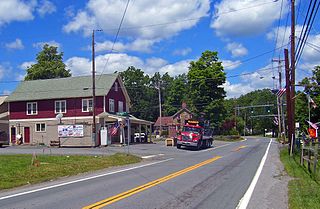
Mill Creek is a 14.5-mile-long (23.3 km) tributary of Opequon Creek, belonging to the Potomac River and Chesapeake Bay watersheds, located in Berkeley County in West Virginia's Eastern Panhandle. Its name reflects its past as a popular site for various types of mills, beginning with one constructed by Morgan Morgan in the mid-18th century near his cabin in present-day Bunker Hill.

Perry Township is in Pike County, Illinois. At the 2010 census, its population was 594 and it contained 310 housing units.
Circleville, New York is a hamlet in the Town of Wallkill, part of Orange County, New York, United States. It is located on NY 302 around the junction with the old Goshen Turnpike, a short distance north of NY 17 and two miles (3 km) south of Bullville. It is three miles (5 km) northeast of Middletown.

Klementynów is a village in the administrative district of Gmina Niedźwiada, within Lubartów County, Lublin Voivodeship, in eastern Poland. It lies approximately 8 kilometres (5 mi) north-east of Lubartów and 31 km (19 mi) north of the regional capital Lublin.
Sezill Volcano is a lava dome in Mount Edziza Provincial Park of northern British Columbia, Canada. It is thought to have formed and last erupted during the Miocene period. The volcano gets its name from being adjacent to Sezill Creek.
The Tahltan First Nation, also known as the Tahltan Indian Band, is a band government of the Tahltan people. Their main community and reserves are located at Telegraph Creek, British Columbia. Their language is the Tahltan language, which is an Athabaskan language also known as Nahanni, is closely related to Kaska and Dunneza. Their Indian and Northern Affairs Canada band number is 682. The Tahltan First Nation is joined with the Iskut First Nation in a combined tribal council-type organization known as the Tahltan Nation.

Dixieland is an unincorporated community in Imperial County, California. It is located 5 miles (8 km) east of Plaster City, at an elevation of 36 feet below sea level.
Horneline Creek Provincial Park is a provincial park in far northern British Columbia, Canada. It is located west of the Kechika River about 130 km south of Lower Post and 30 km north of Denetiah Provincial Park and southwest of the community of Liard River.
Schwertner is an unincorporated community in Williamson County, Texas, United States. Schwertner has a post office with the ZIP code 76573.
Iverson Creek is a creek in northern British Columbia, Canada. It flows northeast into Toozaza Creek.

Calloway Canal is an irrigation canal owned by the North Kern Water Storage District in Kern County, California. It originates from the Kern River, just east of Golden State Highway in Bakersfield. It terminates at reservoirs located south of Whisler Road and east of SR 99, near McFarland.

Temescal Mountains, formerly the Sierra Temescal, are one of the northernmost mountain ranges of the Peninsular Ranges in western Riverside County, in Southern California in the United States. They extend for approximately 25 mi (40 km) southeast of the Santa Ana River east of the Elsinore Fault Zone to the Temecula Basin and form the western edge of the Perris Block.

Temescal Valley in California is a graben rift valley in western Riverside County, California, a part of the Elsinore Trough. The Elsinore Trough is a graben between the Santa Ana Mountain Block to the southwest and the Perris Block on the northeast. It is a complex graben, divided lengthwise into several smaller sections by transverse faults. The Temescal Valley is one of these graben, at the northern end of the trough. The Temescal Valley graben is bounded northeast side by the Lee Lake longitudinal fault and similarly on the southeast by the Glen Ivy Fault.

Riceville is an unincorporated community in Vermilion Parish, Louisiana, United States.

Norridgewock is a census-designated place (CDP) in the town of Norridgewock in Somerset County, Maine, United States. The population was 1,557 at the 2000 census.

Rifle Creek is a stream in Garfield County in the U.S. state of Colorado. Rifle Creek is a tributary to the Colorado River.
Dove is an unincorporated community in Laclede County, in the U.S. state of Missouri.
Bay Creek is a stream in southwest Ripley and southeast Oregon counties in southern Missouri and northern Randolf County in northern Arkansas. It is a tributary of the Eleven Point River.
Bee Fork is a stream in Oregon County of the U.S. state of Missouri. It is a tributary of Mill Creek.
References
Coordinates: 59°30′51″N130°47′27″W / 59.51417°N 130.79083°W