Related Research Articles

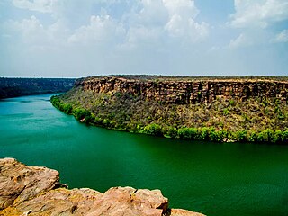
The Godavari is India's second longest river after the Ganga river and drains into the third largest basin in India, covering about 10% of India's total geographical area. Its source is in Trimbakeshwar, Nashik, Maharashtra. It flows east for 1,465 kilometres (910 mi), draining the states of Maharashtra (48.6%), Telangana (18.8%), Andhra Pradesh (4.5%), Chhattisgarh (10.9%) and Odisha (5.7%). The river ultimately empties into the Bay of Bengal through an extensive network of distributaries. Measuring up to 312,812 km2 (120,777 sq mi), it forms one of the largest river basins in the Indian subcontinent, with only the Ganga and Indus rivers having a larger drainage basin. In terms of length, catchment area and discharge, the Godavari is the largest in peninsular India, and had been dubbed as the Dakshina Ganga.

The Aravalli Range is a mountain range in Northern-Western India, running approximately 670 km (420 mi) in a south-west direction, starting near Delhi, passing through southern Haryana, Rajasthan, and ending in Ahmedabad Gujarat. The highest peak is Guru Shikhar on Mount Abu at 1,722 m (5,650 ft). The Aravalli Range is arguably the oldest geological feature on Earth, having its origin in the Proterozoic era.
The Chambal River is a tributary of the Yamuna River in Central and Northern India, and thus forms part of the drainage system of the Ganges. The river flows north-northeast through Madhya Pradesh, running for a time through Rajasthan then forming the boundary between Rajasthan and Madhya Pradesh before turning southeast to join the Yamuna in Uttar Pradesh state.
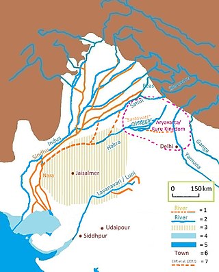
The Luni is the largest river in the Thar Desert of northwest India. It originates in the Pushkar valley of the Aravalli Range, near Ajmer, passes through the southeastern portion of the Thar Desert, and ends in the marshy lands of Rann of Kutch in Gujarat, after travelling a distance of 495 km (308 mi). It is first known as Sagarmati, then after passing Govindgarh, it meets its tributary Sarasvati, which originates from Pushkar Lake and from then on it is called Luni.

Dholpur is a city in the Dholpur district in Rajasthan state of India. It is situated on the left bank of the famous Chambal river. The city is the administrative headquarters of Dholpur District and was formerly seat of the Dholpur princely State of Jats.
The Gambhir River, which is also known as the Utangan River, is an ephemeral (seasonal) river in India which originates in Rajasthan state and confluences with Yamuna in Uttar Pradesh state. Important tributaries of the Gambhir are Banganga, Sesa, Kher, Churaho and Parbati.

Bharatpur District is a district in Rajasthan state in western India. The city of Bharatpur is the District Headquarters, Division Headquarters and Headquarters of Bharatpur Police Range of Rajasthan Police. Bharatpur District is a part of National Capital Region of India Delhi.

Dausa District is a district of Rajasthan state in India within Jaipur division. The city of Dausa is the district headquarters. It has an area of 3432 km² and a population of 1,634,409 in 2011 census. It is surrounded by Alwar District in the north, Bharatpur district in the northeast, Karauli district in the southeast, Sawai Madhopur district in the south, and Jaipur district in the west. The Sawa and Banganga rivers run through the district. It is situated on the National Highway 21 from Jaipur to Agra. It is 55 km to the east of Jaipur and 103 km from Sawai Madhopur.
Karauli District is a district of the state of Rajasthan in western India. It is located in the Braj Bhoomi region. The town of Karauli serves as the administrative headquarters of the district. Karauli district also comes under the Bharatpur Divisional Commissionerate.
Dholpur District is a district of Rajasthan state in Northern India. The town of Dholpur is the district headquarters. Dholpur District is a part of Bharatpur Divisional Commissionerate. It was carved out from the erstwhile Bharatpur District on 15 April 1982.

Gangapur is a city and a municipal council located in Gangapur City District in the Indian state of Rajasthan. It is the administrative headquarters of Gangapur City District. It is Famous for its Sweet Cuisine "Kheermohan" and newly built Kushalgarh Baba Shyam Temple.
Baran is a city in Baran district of the Indian state of Rajasthan. It is a municipality and the district headquarters of Baran district, famous for its 11th century Bhand Devra Temple on banks of Ramgarh crater. It is 339km from the state capital Jaipur near Kota city. Three large rivers, Parban, Parbati, and Kalisindh, flow through the district.

Kaila Devi Temple is a Hindu temple situated in Kailadevi village of Karauli district, in the Indian state of Rajasthan.

The Sahibi river, also called the Sabi River, is an ephemeral, rain-fed river flowing through Rajasthan, Haryana and Delhi states in India. It originates in the eastern slopes of the Saiwar Protected Forest (PF) hills in Sikar District, enters Jaipur district near the foot of these hills, and after initially flowing southeast and east turns northeastwards near Shahpura and continues further till it exits Rajasthan to enter Haryana and further drains into Yamuna in Delhi, where its channeled course is also called the Najafgarh drain, which also serves as Najafgarh drain bird sanctuary. It flows for 300 km of which 157 km is in Rajasthan 100 km is in Haryana and 40 km in Delhi.
Hindaun is one of the 200 Legislative Assembly constituencies of Rajasthan state in India. It is in Karauli district and is reserved for candidates belonging to the Scheduled Castes. It is a part of the Karauli-Dholpur.

Kotra is a tehsil of Udaipur district in Rajasthan, India, consisting of 262 revenue villages and 31 panchayats. The tehsil is bordered to the north by Pali and Sirohi districts, to the east by Gogunda and Jhadol tehsils, and to the south by Gujarat state. The tehsil headquarter is located in the village of Kotra, southwest of the Udaipur at a distance of 57 km and 120 km by road.

Sarmathura is a subdivision located in Dholpur district, in the Indian state of Rajasthan.

The Chambal is a geographical and cultural region in north-central India. It lies along the Chambal and Yamuna river valleys, in southeastern Rajasthan, southwestern Uttar Pradesh and northern Madhya Pradesh.
The Kakund River is a small river in Bharatpur district and Karauli District, Rajasthan, India. It flows from the hills of Karauli district and enters the south-western border of Bayana Tehsil from the Karauli side. Its waters are held up in the Baretha reservoir, which is the largest storage of water in the region.
References
- ↑ Kumar, Rohit; Deshmukh, Benidhar; Sathunuri, Kiran (2021-03-03). "RUSLE Model based Assessment of Soil Erosion in Parbati River Basin, Central India using Google Earth Engine and GIS". doi: 10.5194/egusphere-egu21-1524 .
{{cite web}}: Missing or empty|url=(help) - ↑ Vyas, Sunil Kumar; Sharma, Gunwant; Mathur, Y.P.; Chandwani, Vinay (September 2016). "Interlinking feasibility of five river basins of Rajasthan in India". Perspectives in Science. 8: 83–86. doi: 10.1016/j.pisc.2016.04.002 . ISSN 2213-0209.