
The Pratt & Whitney PW4000 is a family of high-bypass turbofan aircraft engines with certified thrust ranging from 52,000 to 99,040 lbf. Built as the successor to the JT9D series engines, it has found much wider application than its predecessor.

Dolores is a municipality in the El Petén department of Guatemala. It contains 26,269 people. The municipality includes the Maya archaeological sites of Ixkun, Ixtutz, Ixtonton and El Chal. The town is home to the Museo Regional del Sureste de Petén.

The Prague Conservatory or Prague Conservatoire is a music school in Prague, Czech Republic, founded in 1808. Currently, Prague Conservatory offers four or six year study courses, which can be compared to the level of high school diploma in other countries. Graduates of Prague Conservatory can continue their training by enrolling in an institution that offers undergraduate education.

Nyomda River is a river in Kostroma Oblast and Ivanovo Oblast in Russia, a left tributary of the Volga River. It flows into the Nyomda Bay of the Gorky Reservoir of the Volga River. The river is 146 kilometres (91 mi) long, and its drainage basin covers 4,750 square kilometres (1,830 sq mi). The Nemda freezes up in November and remains icebound until mid-April.
Stare Gulczewo is a village in the administrative district of Gmina Słupno, within Płock County, Masovian Voivodeship, in east-central Poland.
Goczki Polskie is a village in the administrative district of Gmina Wierzbinek, within Konin County, Greater Poland Voivodeship, in west-central Poland.
Kazubek is a village in the administrative district of Gmina Wierzbinek, within Konin County, Greater Poland Voivodeship, in west-central Poland.
Golczewo-Gaj is a settlement in the administrative district of Gmina Golczewo, within Kamień County, West Pomeranian Voivodeship, in north-western Poland.

Uneno Station is a train station in Kawanishi, Hyōgo Prefecture, Japan.
Itamarati de Minas is a municipality in the state of Minas Gerais in the Southeast region of Brazil.

The 4158th Strategic Wing is a discontinued United States Air Force unit. It was active in Alaska from 1960 to 1966 as a control and support organization for Strategic Air Command (SAC) units deployed to Elmendorf Air Force Base, Alaska.
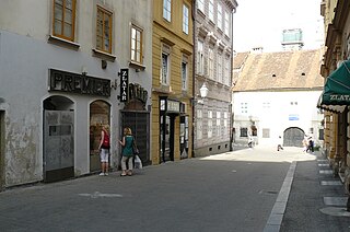
Krvavi most is a street in the heart of Zagreb, capital of Croatia. It is named after the former bridge over the Medveščak creek, which was rendered useless after the covering of the creek. Although the bridge became the street, the name stayed because of historical reasons – as a reminder of history and a witness of Zagreb's past.
Selišta is a village in the municipality of Bileća, Republika Srpska, Bosnia and Herzegovina.
Plažane is a village situated in Despotovac municipality in Serbia.
Chah-e Qolmi is a village in Kuh Shah Rural District, Ahmadi District, Hajjiabad County, Hormozgan Province, Iran. At the 2006 census, its population was 110, in 27 families.
Sergeyevka is a town and the administrative center of Shal akyn District in North Kazakhstan Region of Kazakhstan. Population: 7,661 ;9,470.
Beeches Farm is a farm and country house in Bexhill, Rother in East Sussex, England. A Grade II listed building, it dates to at least the 18th century, and is a two-storey building with stuccoed brickwork on the ground floor, and a hipped tiled roof.

Oranienplatz is a square in Kreuzberg, Berlin, Germany.

Collegium Da Vinci is a Polish private university in Poznan.


