
Lombardy is an administrative region of Italy that covers 23,844 km2 (9,206 sq mi); it is located in the northern-central part of the country and has a population of about 10 million people, constituting more than one-sixth of Italy's population. Over a fifth of the Italian gross domestic product (GDP) is produced in the region.

Ticino, sometimes Tessin, officially the Republic and Canton of Ticino or less formally the Canton of Ticino, is one of the 26 cantons forming the Swiss Confederation. It is composed of eight districts and its capital city is Bellinzona. It is also traditionally divided into the Sopraceneri and the Sottoceneri, respectively north and south of Monte Ceneri. Red and blue are the colours of its flag.

Garfield Township, officially the Charter Township of Garfield, is a charter township of Grand Traverse County in the U.S. state of Michigan. As of the 2020 census, the township had a total population of 19,499.
Campione d'Italia is a comune of the Province of Como in the Lombardy region of Italy and an enclave surrounded by the Swiss canton of Ticino. At its closest, the enclave is less than one kilometre (0.6 mi) from the rest of Italy, but the intervening mountainous terrain requires a journey by road through the Swiss village of Bissone of over 14 km (9 mi) to reach the nearest Italian town, Lanzo d'Intelvi, and over 28 km (17 mi) to reach the city of Como.

Bolu Province is a province situated in north-western Turkey. It is located between the capital, Ankara and the largest city in the country, Istanbul. It covers an area of 7,410 km2 and the population is 311,810.
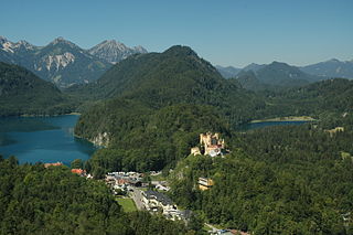
Hohenschwangau is a former village and now an urban district of the municipality of Schwangau, Ostallgäu district, Bavaria, Germany.
Babine Lake Marine Provincial Park is a provincial park in British Columbia, Canada. The park was established by Order-in-Council in 1993, comprising two sites at Pendleton Bay totalling 36.9 hectares. Another was established in the same year at Smithers Landing, comprising approximately 157.8 hectares. Three more sites were added in 2001, Hook (Deep) Bay, Pierre Creek, Pinkut Creek and Sandpoint. All sites combined comprise approximately 492 hectares.
Bernate Ticino is a comune (municipality) in the Metropolitan City of Milan in the northern Italian region Lombardy, located about 25 kilometres (16 mi) west of Milan.

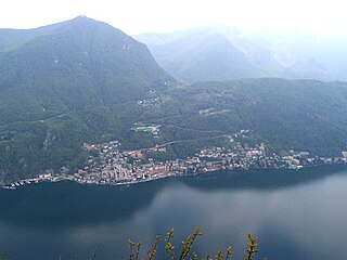
Capolago is a village situated at the south-eastern extremity of Lake Lugano, in the Swiss canton of Ticino. Originally a municipality in its own right, Capolago is now a quarter of the municipality of Mendrisio, itself part of the district of Mendrisio.

Canale Villoresi is a canal in Italy; it was the brainchild of Lombardy engineer Eugenio Villoresi.

Highway 71 is an east-west highway that passes through the eastern Jezreel Valley and the Beit She'an Valley, below the north slopes of the Gilboa mountains, in northern Israel. The road follows a path parallel to the Harod Creek in the Harod Valley and to the Jezreel Valley railway. It is 35 kilometres (22 mi) long, and leads from Afula in the west, via Beit She'an, to the Jordan River Border Crossing in the east. The Navot interchange located approximately 10 km southeast of Afula provides a shortcut via Route 675 through the Ta'anakh region from Highway 71 and Beit She'an to Highway 65 and central Israel.

Affori is a ward of Milan, Italy, part of the Zone 9 administrative division of the city, located north of the city centre. It borders with the wards of Bruzzano, Comasina, Bovisasca, Dergano and Niguarda. Before being annexed to Milan in 1923, it was an autonomous comune.
Gee Creek is a 4th order tributary to the Columbia River, a.k.a. small creek, within Clark County, Washington named for William Gee, an early pioneer upon whose land the stream arose from. The Upper Gee Creek watershed, with an 8.7-square-mile (23 km2) drainage basin, is completely located within the Ridgefield quadrangle. The mainstem extends approximately 11.5 miles (18.5 km), of which 4.9 miles (7.9 km) are located within the Upper Gee Creek basin. Originating in the hills along Interstate 5, through Ridgefield, Washington and empties into a series of lakes on the Columbia River Floodplain. Abrams Park in Ridgefield is a local access point for Gee Creek and since 2003, has had a stream flow gauge installed to collect hydrological data. The lowest segment of Gee Creek meanders for 3 miles (4.8 km) through the Ridgefield National Wildlife Refuge.
Stonewall is a neighborhood in southwestern Lexington, Kentucky, United States. Its boundaries are Clays Mill Road to the east, Man O War Boulevard to the south, New Circle Road to the north, and a combination of Hyde Park Drive, Blenheim Way, and Gladman Way to the west.

TILO is a limited company established in 2004 as a joint venture between Italian railway company Trenord and Swiss Federal Railways (SBB CFF FFS); both companies participate in the equity of TILO SA with participation of 50%.

The University of Applied Sciences and Arts of Southern Switzerland is one of the Universities of Applied Sciences of the Swiss Confederation. SUPSI offers more than 30 bachelor and master courses, complementing theoretical scientific knowledge and practical technological advances applied to real projects. Various departments of SUPSI are mainly based in Southern Switzerland. Instruction is mainly in Swiss Italian, with some courses delivered in English and German.

The Lugano Prealps are a mountain range in the western part of the Alps. They are located in Canton Ticino and in Lombardy.
The Port of Rizhao is a natural deep-water seaport on the coast of the city of Rizhao, Shandong Province, People's Republic of China, located on the southern shore of Shandong Peninsula, opening to the Yellow Sea. It has 46 deep-water berths in two main port areas. In 2012 it reached a throughput of 284 million metric tons, making it the tenth-busiest port in China.
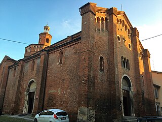
San Teodoro is a Romanesque-style Roman Catholic church in the town center of Pavia, Italy.

The Parco del Roccolo is a local park of interest to more than one municipality and it is located between the rivers Olona and Ticino in the northern part of the Po Valley, in a north-western area in the province of Milan, on the southern edge of the Altomilanese. The park includes wooded and agricultural areas in the municipalities of Arluno, Busto Garolfo, Canegrate, Casorezzo, Nerviano and Parabiago, with a surface of 1595 hectares.

