The Eastern Suburbs is the metropolitan region directly to the east and south-east of the central business district in Sydney, New South Wales, Australia.

St George Area is a region of Sydney, part of the southern suburbs of Sydney, in the state of New South Wales, Australia. The area includes all the suburbs in the local government area of Georges River Council and the part of Bayside Council which was Rockdale City prior to 2016. The eastern boundary of the district is Lady Robinson Beach on Botany Bay. The name "St George" derives from the cadastral Parish of St George, and the area was later covered by the St George County Council, the electricity supplier for the councils in this region.

Alexandria is an inner-city suburb of Sydney, New South Wales, Australia. Alexandria is located 4 kilometres south of the Sydney central business district and is part of the local government area of the City of Sydney. The postcode is 2015.
South-Eastern Sydney is the metropolitan area directly to the south and east of the Sydney central business district in Sydney, New South Wales, Australia.

The Division of Sydney is an Australian electoral division in the state of New South Wales.

Bilgola Plateau is a suburb in Sydney, in the state of New South Wales, Australia.
Carey Bay is a suburb of the City of Lake Macquarie in New South Wales, Australia, and is located on a peninsula southeast of the town of Toronto on the western side of Lake Macquarie.

Willoughby Parish, Cumberland is one of the 57 parishes of Cumberland County, New South Wales, Australia, a cadastral unit for use on land titles. The suburb of Willoughby and the City of Willoughby LGA are in a similar area. Willoughby Parish roughly covers the peninsula formed by the Lane Cove River, Sydney Harbour and Middle Harbour on three sides, with the northern boundary of the Parish roughly across the narrowest point of the peninsula. It roughly correlates with the region traditionally known as the "Lower North Shore", although that term is also sometimes used in a wider sense that includes land in neighbouring Hunters Hill Parish.

Marramarra Parish, Cumberland is one of the 57 parishes of Cumberland County, New South Wales, a cadastral unit for use on land titles.
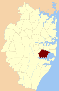
St George Parish is one of the 57 parishes of Cumberland County, New South Wales, a cadastral unit for use on land titles. It is bounded in the north by the Cooks River, in the west of Cox's Creek and Salt Pan Creek, and in the south by the Georges River.
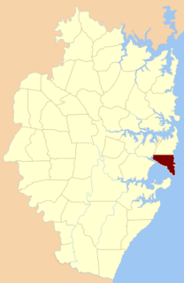
Botany Parish, Cumberland is one of the 57 parishes of Cumberland County, New South Wales, a cadastral unit for use on land titles. It contains the area to the north of Botany Bay and to the east of part of Cooks River. It includes the suburbs of La Perouse, Hillsdale, Banksmeadow and Maroubra. It also includes Sydney Airport. It roughly corresponds to the "South-Eastern Suburbs" of Sydney, which are sometimes counted as part of the Eastern Suburbs together with the suburbs in the Parish of Alexandria to the north.

Petersham Parish is one of the 57 parishes of Cumberland County, New South Wales, a cadastral unit for use on land titles. It is located to the south of Iron Cove, Rozelle Bay and the Parramatta River, and to the north of Cooks River. It includes the suburbs of Balmain, Leichhardt, Petersham, Newtown, Marrickville, Tempe, Glebe and St Peters. It roughly corresponds to the eastern half of the Inner West region, with the neighbouring Parish of Concord making up the western half.

Concord Parish is one of the 57 parishes of Cumberland County, New South Wales, a cadastral unit for use on land titles. It is located to the south of the Parramatta River between Homebush Bay and Iron Cove; and to the north of Cooks River. It includes the suburbs of Homebush, most of Strathfield, Burwood, Croydon, Concord, Canada Bay and Abbotsford. It covers the local government areas of City of Canada Bay and the Municipality of Burwood and most of the Municipality of Strathfield. It roughly corresponds to the western half of the Inner West region, with the neighbouring Parish of Petersham making up the eastern half.

Liberty Plains Parish is one of the 57 parishes of Cumberland County, New South Wales, a cadastral unit for use on land titles. It is bounded by Parramatta Road in the north; the boundary between Flemington and Homebush, a small part of Cooks River and Liverpool Road in the east; the Hume Highway also in the south; and Woodville Road in the west. It includes the suburbs of Homebush West (Flemington), part of Strathfield, Auburn, Regents Park, Potts Hill, Sefton, Chester Hill, Bass Hill and Lidcombe. It also includes the Rookwood Cemetery. Before the parish was proclaimed in 1835, the Liberty Plains district was in the same area. The name had been given when the first settlers had desired a settlement midway between Parramatta and Sydney city. The name is still used on a motor inn in the area. In the 1851 census there were 49 houses and 270 people in the Liberty Plains parish.

St John Parish is one of the 57 parishes of Cumberland County, New South Wales, a cadastral unit for use on land titles. It is named after St John's Cathedral in Parramatta, New South Wales which opened in 1803, on which the civil parish is roughly centred. The parish is shaped like a "T", with the northern part stretching from Toongabbie to the western shore of Homebush Bay. The southern end is at Prospect Creek near Yennora. Woodville Road and Parramatta Road form the boundaries to the south-east. The Old Prospect Road is part of the boundary in the west.

St Andrew Parish, Cumberland is one of the 57 parishes of Cumberland County, New South Wales, a cadastral unit for use on land titles. It is one of the four small parishes in the Sydney city area, and is named after the church of St Andrew's. The parish was named while the church was still in the planning stages. The parish includes Pyrmont and the Darling Harbour area. It is bounded by Wattle Street in the south west, George Street in the south and east, and King Street in the north-east. It includes Town Hall railway station, which is on the eastern end of the parish.
The metropolis of Sydney in New South Wales, Australia, is informally subdivided into a number of geographic regions. These areas sometimes, but not always, roughly coincide with official boundaries of suburbs, local government authorities, or cadastral units, and some of the customary regions do not have well defined boundaries at all. Some commonly referred to regions overlap: for example, "Canterbury-Bankstown" is often referred to as a region, but it is also part of the "South Western Sydney" region. The regions themselves are not used as a formal jurisdiction, and do not have administrative or legislative bodies.

Bardwell Creek, an urban watercourse of the Cooks River catchment, is located in the southern suburbs of Sydney, in New South Wales, Australia.
Gore Creek, an urban watercourse that is part of the Parramatta River catchment, is located in Northern Suburbs region of Sydney, Australia.
Nelanglo Parish is a civil parish of King County, New South Wales.
