Related Research Articles

Fort Grey is a remote civil parish of Poole County in far North West New South Wales. located at 29.1731°S 141.0307°E.
Pinaroo is a remote civil parish of Poole County in far north west New South Wales, located at 29°08′04″S 141°06′55″E.
Nantomoko is a remote civil parish of Poole County in far northwest New South Wales. located at 29.2143°S 141.0805°E
Wirratcha Parish is a remote rural locality and civil parish of Evelyn County in far northwest New South Wales. located at 29°38′31″S 142°01′00″E.

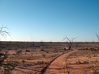
Mount Blackwood, New South Wales located at 29°48′37″S 141°31′10″E, is a remote rural locality and civil parish of Evelyn County in far northwest New South Wales. located at 30°04′42″S 142°45′50″E, east of the Silver City Highway . The geography of the parish is mostly the flat, arid landscape of the Channel Country. The parish has a Köppen climate classification of BWh.
Milring Parish is a remote rural locality and civil parish of Evelyn County in far northwest New South Wales. located at 29°54′29″S 141°40′53″E.
Coally is a remote rural locality and civil parish of Evelyn County, New South Wales in far northwest New South Wales located at 29°51′00″S 141°50′39″E.
Mount Wood, New South Wales is a remote civil parish of Tongowoko County, New South Wales near Milparinka, New South Wales.
Mouloonk is a remote rural locality and civil parish of Evelyn County in far northwest New South Wales. located at 30°09′04″S 141°07′08″E.

Haynes is a remote civil parish of Evelyn County in far northwest New South Wales, located at 30°24′24″S 141°04′
Quintyambi is a remote rural locality and civil parish of Evelyn County in far northwest New South Wales. located at 30°18′40″S 141°05′05″E.
Bimpia located at 30°47′21″S 142°03′46E is a remote civil parish of Mootwingee County in far North West New South Wales.

Booraboonara located at 31°25′02″S 141°44′53″E is a remote civil parish of Mootwingee County in far North West New South Wales.
Boorla located at 30.968333°S 141.859167°E is a remote civil parish of Mootwingee County in far North West New South Wales.
Gooruba, New South Wales, located at 30°23′56″S 142°11′53″E, is a remote civil parish of Mootwingee County in far North West New South Wales.
The Parish of Essie, New South Wales is a remote civil parish of Evelyn County, New South Wales in far northwest New South Wales, located at 29.839722°S 141.134722°E, on the border with South Australia.

Parish of Paradise, New South Wales is a remote civil parish of Evelyn County, New South Wales in far northwest New South Wales. located at 29.850000°S 141.844167°E on the border with South Australia.
Scott Parish, New South Wales is a remote rural locality and civil parish of Evelyn County, New South Wales in far northwest New South Wales. located at 29°38′31″S 142°01′00″E.
Wonominta, New South Wales is a remote rural locality and civil parish of Evelyn County in far northwest New South Wales. located at 30°18′40″S 141°05′05″E.
Parish of Kooltoo, New South Wales is a remote civil parish of Yantara County in far North West New South Wales. The geography of the parish is mostly the flat, arid landscape of the Channel Country. The parish has a Köppen climate classification of BWh.
References
- ↑ "Poole County". Geographical Names Register (GNR) of NSW. Geographical Names Board of New South Wales.
- ↑ / Map of the County of Poole : Western Division, .
- ↑ Olive Downs campground.
- ↑ Peel, M. C.; Finlayson, B. L.; McMahon, T. A. (2007). "Updated world map of the Köppen–Geiger climate classification" (PDF). Hydrol. Earth Syst. Sci. 11: 1633–1644. doi: 10.5194/hess-11-1633-2007 . ISSN 1027-5606.(direct: Final Revised Paper)
- ↑ The Sydney Morning Herald Sat 5 Mar 1932, Page 9.
- ↑ Sturt's Central Australian Expedition Archived 1 March 2018 at the Wayback Machine .
- ↑ The Burke and Wills Expedition Archived 1 March 2018 at the Wayback Machine .
- ↑ NSW National Parks and Wildlife service, Draft Plan of Management Sturt National Park, (2017) p 22.
| | This Far West geography article is a stub. You can help Wikipedia by expanding it. |