
Cumberland is a historic county of North West England that had an administrative function from the 12th century until 1974. It was bordered by Northumberland to the east, County Durham to the southeast, Westmorland and Lancashire to the south, and the Scottish counties of Dumfriesshire and Roxburghshire to the north. It formed an administrative county from 1889 to 1974 and now forms part of Cumbria.

Cumberland County is a county in the State of New South Wales, Australia. Most of the Sydney metropolitan area is located within the County of Cumberland.

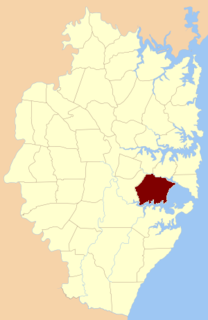
The Parish of Sutherland is one of the 57 parishes in Cumberland County, New South Wales, a cadastral unit for use on land titles. It was originally proclaimed as the parish of Southerland with an 'o', but was misspelled without it on the government gazette. It includes all of the Kurnell peninsula, with Botany Bay and the Georges River to the north; part of the Woronora River to the west; and Port Hacking to the south. Suburbs within the parish include Cronulla, Miranda, Woolooware, Caringbah, Gymea, Sutherland, Sylvania Waters and Oyster Bay.

Minto Parish is one of the 57 parishes of Cumberland County, New South Wales, a cadastral unit for use on land titles. It includes Minto, Ingleburn, Glenfield and Macquarie Fields. Its eastern boundary is the Georges River, and western boundary was at the Great Southern Road.

St James Parish, Cumberland is one of the 57 parishes of Cumberland County, New South Wales, a cadastral unit for use on land titles. It is one of the four small parishes in the Sydney city area, which is named after the Anglican church of St James, which was consecrated in 1824. The name St James is also used today for the railway station in the same area.
St George Parish is one of the 57 parishes of Cumberland County, New South Wales, a cadastral unit for use on land titles. The name is used as the region name today.

Petersham Parish is one of the 57 parishes of Cumberland County, New South Wales, a cadastral unit for use on land titles. It is located to the south of Iron Cove, Rozelle Bay and the Parramatta River, and to the north of Cooks River. It includes the suburbs of Balmain, Leichhardt, Petersham, Newtown, Marrickville, Tempe, Glebe and St Peters.
St Andrew Parish, Cumberland is one of the 57 parishes of Cumberland County, New South Wales, a cadastral unit for use on land titles. It is one of the four small parishes in the Sydney city area, which is named after the church of St Andrew's. The parish was named while the church was still in the planning stages. The parish includes Pyrmont and the Darling Harbour area. It is bounded by Wattle Street in the south west, George Street in the south and east, and King Street in the north-east. It includes Town Hall railway station, which is on the eastern end of the parish.
St Philip Parish is one of the 57 parishes of Cumberland County, New South Wales, a cadastral unit for use on land titles. It is located on the western part of the original colony at Sydney Cove, which was to the west of the Tank Stream. It is one of the four small parishes in the Sydney city area and is named after the church of St Philip's. It includes the southern end of the Sydney Harbour Bridge, The Rocks, Dawes Point and Millers Point. It is bounded by Sydney Harbour in the north, King Street in the south, George Street in the south-east, and what was once the Tank Stream in the east. The northern end of Darling Harbour is the boundary in the west. It includes Wynyard railway station.
The Parish of Sutton Forest is a parish of the County of Camden in the Southern Highlands region of New South Wales. It includes the land to the south and south-west of the small village centre presently known as Sutton Forest. The northern boundary of the parish is the Illawarra Highway and part of Canyonleigh Road. Part of Paddys River is the south-western boundary. The Southern Highlands railway line passes through the parish and is near the boundary in the east. The Hume Highway passes through a small part of the parish in the north-west. The parish includes the towns of Exeter and Bundanoon. The town of Bundanoon is at the southern edge of the Parish of Sutton Forest, with the Parish of Bundanoon just to the south.

The Parish of Bong Bong is a parish of the County of Camden in the Southern Highlands region of New South Wales. Moss Vale is the largest town in the area. The parish includes the small township of Bong Bong, which was the first village established in the Southern Highlands. The Wingecarribee River forms part of the boundary of the parish in the north and north-east. The Hume Highway passes through a small part of the parish in the north-west. Bowral is just beyond the boundary of the parish in the north-east. Berrima is located just to the north-west. The Illawarra Highway passes through the parish from east to west, and is also a small part of the boundary in the south-west.
The Parish of Berrima is a parish of the County of Camden in the Southern Highlands region of New South Wales. Berrima is the largest town in the parish, and the parish includes the land to the north and north-east of this town. The Wingecarribee River forms part of the boundary of the parish in the south, although some of the land near Berrima that is to the south of the river is also included in the parish. Both the old and new Hume Highway pass through the parish from the south-west to the north-east. Gibraltar creek is part of the boundary in the north-east. Bowral and Mittagong are located just to the east of the parish, along with the Southern Highlands railway line. Mandemar is located in the north-west of the parish.
The Parish of Mittagong is a parish of the County of Camden in the Southern Highlands region of New South Wales. It includes the town of Bowral and the southern parts of Mittagong.
The Parish of Murrimba is a parish of the County of Camden in the Southern Highlands region of New South Wales. It is located at the western end of the County of Camden, with Paddys River the boundary to the west and south. Canyonleigh road is the boundary to the north. The Hume Highway passes through near the middle of the parish, running from south-west to north-east. The parish includes Penrose State Forest, although not the town of Penrose, which is further south.
The Parish of Wilton is a parish of the County of Camden in New South Wales, Australia. It is located in the area around where Picton Road crosses the Hume Highway, and the area around nearby Wilton. It is bounded by the Cataract River in the east, the Nepean River in the west and north, and the Cordeaux River in the south-west. Almost the entire boundary of the parish uses rivers, except for a small area in the south-east. The parish extends as far south as Cordeaux Dam.

St Luke Parish is one of the 57 parishes of Cumberland County, New South Wales, a cadastral unit for use on land titles. It is bounded by Prospect Creek in the north-east, Georges River in the south-east, and Cowpasture Road in the west. It was named after the Anglican church of St Lukes in Liverpool, which was completed in 1819. The parish is mentioned in various legislation dealing with property law for the city of Liverpool.

Manangle Parish, Cumberland is one of the 57 parishes of Cumberland County, New South Wales, a cadastral unit for use on land titles. Its eastern boundary is the Georges River, and western boundary the Nepean River. It includes the southern Sydney suburbs of Menangle Park, Gilead, Rosemeadow and part of Glen Alpine. Major roads in the area include the South Western Freeway, Menangle Road and Appin Road.

Appin Parish, Cumberland is one of the 57 parishes of Cumberland County, New South Wales, a cadastral unit for use on land titles. Its eastern boundary is the Georges River, and western boundary the Nepean River and Cataract River. It is centred on Appin.
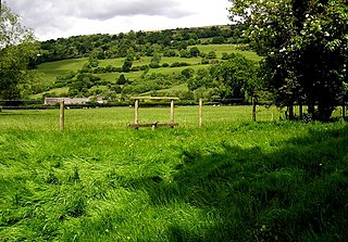
Llanwenarth is a small village and parish in the Usk Valley of Monmouthshire, south-east Wales, United Kingdom. It is in the community of Llanfoist Fawr and covered by the electoral ward of Llanwenarth Ultra.

The Jenolan River, a perennial river that is part of the Hawkesbury-Nepean catchment, is located in the Central Tablelands region of New South Wales, Australia.
