Park Lake, Kentucky

Last updated

Park Lake, Kentucky
Neighborhood
KYMap-doton-ParkLake.PNG
Location of Park Lake, Kentucky
Coordinates: 38°20′43″N85°28′28″W / 38.34528°N 85.47444°W / 38.34528; -85.47444
Country United States
State Kentucky
County Oldham
Area
  Total0.1 sq mi (0.3 km2)
  Land0.1 sq mi (0.3 km2)
  Water0.0 sq mi (0.0 km2)
Elevation
751 ft (229 m)
Population
 (2000)
  Total537
  Density5,470.0/sq mi (2,112.0/km2)
Time zone UTC-5 (Eastern (EST))
  Summer (DST) UTC-4 (EDT)
FIPS code 21-59260
GNIS feature ID1669490

Park Lake is a neighborhood of the city of Crestwood in Oldham County, Kentucky, United States. The population was 537 at the 2000 census, at which time it was a separate city. Crestwood annexed Park Lake on May 1, 2006. [1]

Contents

Geography

Park Lake is located at 38°20′43″N85°28′28″W / 38.345351°N 85.474310°W / 38.345351; -85.474310 . [2]

According to the United States Census Bureau, the city had a total area of 0.1 square miles (0.26 km2), all land.

Demographics

As of the census [3] of 2000, there were 537 people, 159 households, and 145 families residing in the city. The population density was 5,470.1 inhabitants per square mile (2,112.0/km2). There were 161 housing units at an average density of 1,640.0 per square mile (633.2/km2). The racial makeup of the city was 97.02% White, 0.37% Native American, 1.12% Asian, 0.74% from other races, and 0.74% from two or more races. Hispanic or Latino of any race were 0.74% of the population.

There were 159 households, out of which 67.9% had children under the age of 18 living with them, 78.6% were married couples living together, 10.7% had a female householder with no husband present, and 8.8% were non-families. 6.9% of all households were made up of individuals, and none had someone living alone who was 65 years of age or older. The average household size was 3.38 and the average family size was 3.56.

In the city the population was spread out, with 38.2% under the age of 18, 5.4% from 18 to 24, 41.5% from 25 to 44, 13.6% from 45 to 64, and 1.3% who were 65 years of age or older. The median age was 31 years. For every 100 females, there were 100.4 males. For every 100 females age 18 and over, there were 97.6 males.

The median income for a household in the city was $63,750, and the median income for a family was $64,167. Males had a median income of $50,156 versus $31,583 for females. The per capita income for the city was $21,384. None of the families and 0.6% of the population were living below the poverty line, including no under eighteens and none of those over 64.

Related Research Articles

<span class="mw-page-title-main">Healy Lake, Alaska</span> CDP in Alaska, United States

Healy Lake is a census-designated place (CDP) in Southeast Fairbanks Census Area, Alaska, United States. The population was 13 at the 2010 census, down from 37 in 2000.

<span class="mw-page-title-main">Rickardsville, Iowa</span> City in Iowa, United States

Rickardsville is a city in Dubuque County, Iowa, United States. The population was 202 at the time of the 2020 census, up from 191 in 2000.

<span class="mw-page-title-main">Franklin, Iowa</span> City in Iowa, United States

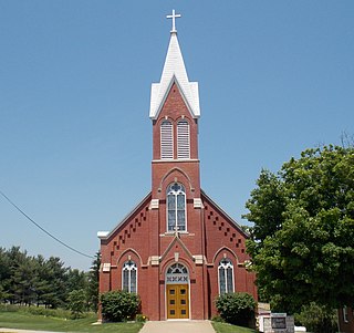
Franklin is a city in Lee County, Iowa, United States. Franklin is noted for its stone and brick Federal architecture, uncommon in Iowa. The population was 131 at the time of the 2020 census. It is part of the Fort Madison–Keokuk, IA-MO Micropolitan Statistical Area.

<span class="mw-page-title-main">Ackworth, Iowa</span> City in Iowa, United States

Ackworth is a city in Warren County, Iowa, United States. The population was 115 at the 2020 census.

<span class="mw-page-title-main">Viola, Kansas</span> City in Sedgwick County, Kansas

Viola is a city in Sedgwick County, Kansas, United States. As of the 2020 census, the population of the city was 115.

Broad Fields is a neighborhood of St. Matthews, Kentucky. Broad Fields was a Sixth Class city in Jefferson County, Kentucky, United States. Broad Fields was incorporated on May 24, 1957. Broad Fields was dissolved on July 1, 2000, and annexed by St. Matthews on January 8, 2001. The population was 250 at the 2000 census.

Fairmeade is a neighborhood of St. Matthews, Kentucky. The population was 264 at the 2000 census.

Keeneland is a former city in Jefferson County, Kentucky, United States, that was dissolved on January 1, 2001 and annexed by the neighboring City of Lyndon. Keeneland is now a neighborhood of Lyndon and also a part of Louisville Metro.

<span class="mw-page-title-main">Moorland, Kentucky</span> City in Kentucky, United States

Moorland is a home rule-class city in Jefferson County, Kentucky, United States. The population was 431 as of the 2010 census.

<span class="mw-page-title-main">Ten Broeck, Kentucky</span> City in Kentucky, United States

Ten Broeck is a home rule-class city in Jefferson County, Kentucky, United States. The population was 103 at the 2010 census.

<span class="mw-page-title-main">Wildwood, Kentucky</span> City in Kentucky, United States

Wildwood is a home rule-class city in Jefferson County, Kentucky, United States. The population was 261 at the 2010 census.

<span class="mw-page-title-main">Woodland Hills, Kentucky</span> City in Kentucky, United States

Woodland Hills is a home rule-class city in Jefferson County, Kentucky, United States. The population was 696 at the 2010 census.

Trondhjem Township is a township in Otter Tail County, Minnesota, United States. The population was 171 at the 2000 census.

<span class="mw-page-title-main">Fifty Lakes, Minnesota</span> City in Minnesota, United States

Fifty Lakes is a city in Crow Wing County, Minnesota, United States. The population was 387 at the 2010 census. It is part of the Brainerd Micropolitan Statistical Area.

<span class="mw-page-title-main">Crestwood Village, New Jersey</span> Populated place in Ocean County, New Jersey, US

Crestwood Village is an unincorporated community and census-designated place (CDP) located within Manchester Township, in Ocean County, in the U.S. state of New Jersey. As of the 2010 United States Census, the CDP's population was 7,907.

<span class="mw-page-title-main">Pine Ridge at Crestwood, New Jersey</span> Populated place in Ocean County, New Jersey, US

Pine Ridge at Crestwood is an unincorporated community and census-designated place (CDP) located within Manchester Township, in Ocean County, in the U.S. state of New Jersey. As of the 2010 United States Census, the CDP's population was 2,369.

<span class="mw-page-title-main">Parc, New York</span> Census-designated place in New York, United States

Parc is a location and census-designated place in Clinton County, New York, United States. The name "Parc" is derived from the official name for the 3,447-acre (13.95 km2) industrial site, which is PARC, an acronym for the Plattsburgh Airbase Redevelopment Corporation. PARC was established for the purpose of redeveloping the Plattsburgh Air Force Base after it closed on September 25, 1995. PARC is now operated by the Plattsburgh Air Base Development Authority, and the massive airfield is now Plattsburgh International Airport. The population of the Parc CDP was 254 at the 2010 census. Parc is located in the town of Plattsburgh and is bordered to the north by the city of Plattsburgh.

<span class="mw-page-title-main">Oberon, North Dakota</span> City in North Dakota, United States

Oberon is a city in Benson County, North Dakota, United States. The population was 101 at the 2020 census. Oberon was founded in 1886.

<span class="mw-page-title-main">Martin, North Dakota</span> City in North Dakota, United States

Martin is a city in Sheridan County, North Dakota, United States. The population was 63 at the 2020 census.

<span class="mw-page-title-main">Woodbourne-Hyde Park, Ohio</span> Unincorporated community & former census-designated place in Ohio, United States

Woodbourne-Hyde Park is an unincorporated area in Washington Township in Montgomery County, Ohio, United States. A Suburb of Dayton. It was delineated as a census-designated place (CDP) at the 2000 census, at which time its population was 7,910. It was not delineated as a CDP for the 2010 census.

References

  1. "Boundary Changes". Geographic Change Notes: Kentucky. Population Division, United States Census Bureau. March 18, 2009. Archived from the original on February 6, 2006. Retrieved May 18, 2009.
  2. "US Gazetteer files: 2010, 2000, and 1990". United States Census Bureau. February 12, 2011. Retrieved April 23, 2011.
  3. "U.S. Census website". United States Census Bureau . Retrieved January 31, 2008.